There’s ongoing interest in the Suburban Rail Loop project, with a new batch of information published last month.
Unfortunately some content is somewhat hidden in an “Virtual Engagement Room“, which looks flashy, but is slow and awkward to navigate, and means useful information probably isn’t indexed on Google or archived in Archive.org. Thankfully most or all of it seems to be replicated on other parts of the web site, including the Factsheets page.
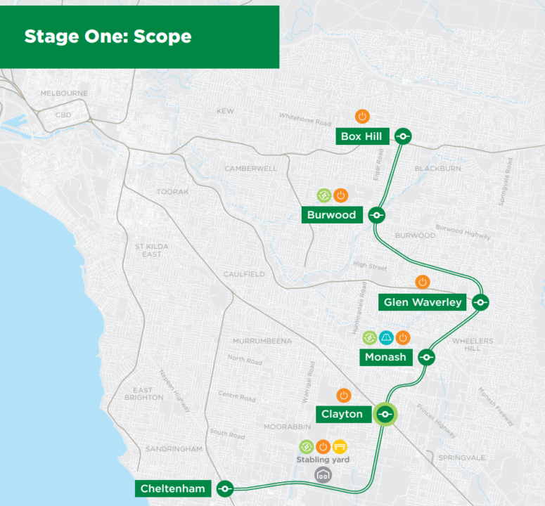
The new information includes more detail of the proposed station locations. If you take a look, you’ll see some of them are a short distance from existing Metro stations. Just a few months ago, I was assured by the government that all of them will include paid area interchanges – you won’t have to exit to the street to change trains.
After all, the whole project is designed to connect existing rail lines – almost to the exclusion of anything else (for instance, a station between Southland and Clayton). So it will be important that they stick to their word on this.
Estimating the service frequency
As usual with these big infrastructure projects, all of the emphasis is on the infrastructure, not the service… even though one is useless without the other.
But there are some clues. The Interactive Map includes this snippet about the stabling yard: “When services start, a total of 13 trains will be stabled on site to service Stage One.”
Allowing for maintenance and spares, with a fleet of 13 trains, one might expect 10 or 11 to be in service at times of peak frequency.
(Another document mentions up to 30 trains in stabling. This appears to be a future requirement, possibly to additionally service Stage 2 of the line.)
Meanwhile the government claims a 22 minute travel time for the Stage 1 line from Southland to Box Hill. Add some padding for potential delays, and layover at each end, let’s say it’s a round trip of about 60 minutes.
Round trip of 60 minutes divided by 10 or 11 trains means a peak frequency of about every 5 or 6 minutes.
This is not too shabby, and would achieve the aim of a Turn Up And Go service connecting the major rail lines to the east and south-east of the City as well as major university precincts and suburban activity centres.
The key question here might be: at what times will this high frequency apply?
Will it be like most other Melbourne train lines currently, with Turn Up And Go service only applying for a few hours per weekday, or will it be all day every day, first to last train, like in a Real City?
And will the rest of the rail network and the local connecting buses also implement an all-day frequent service, so the vision of fast trips and seamless connections around the public transport network becomes a reality?
Because ultimately, a SRL needs to be part of a network of frequent services. That’s the only way it can live up to its promise and potential.
- Some locals in Heatherton are campaigning against the preferred stabling yard site
- This may have prompted the project to publish more information about the stabling yard, including details of how they assessed the alternative sites
19 replies on “Suburban Rail Loop: a train every 5 or 6 minutes?”
Do you think the frequency would change once other parts of the loop are built??
The fact that the SRL will be so frequent, or at least the capability to do so, makes me question the dog leg to Glen Waverley even more. I get that Glen Waverley is an activity centre but if the SRL and connecting services are timed appropriately or at least frequently enough then there shouldn’t be such an issue for passengers to transfer at say Mount Waverley instead.
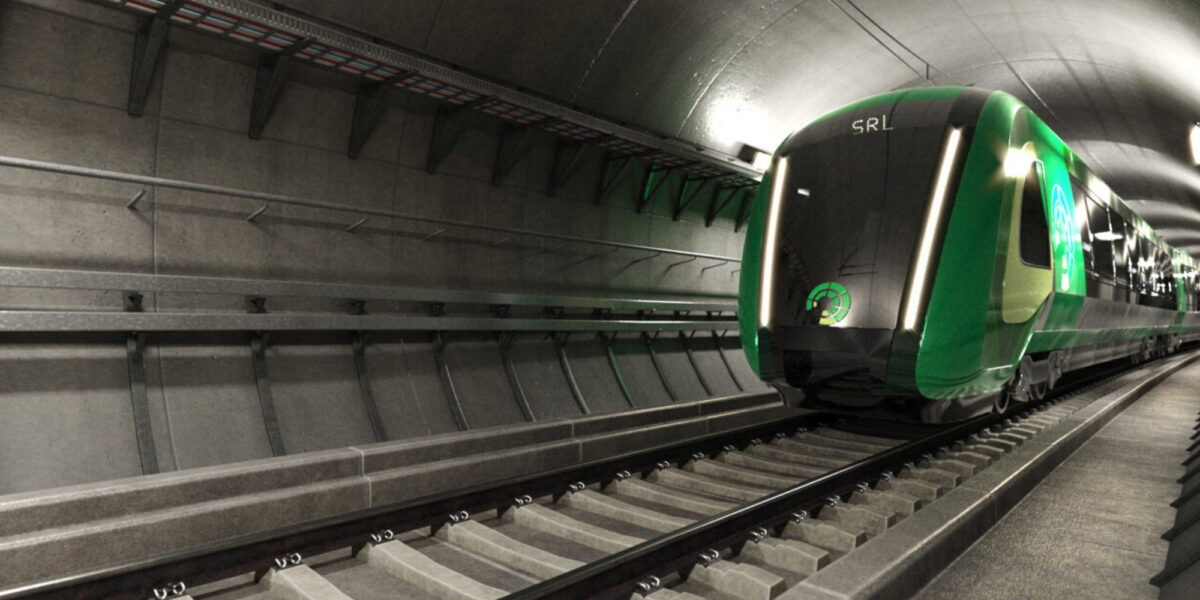
I haven’t trawled through all the information, but I see it’s stated that the infrastructure will enable “a new high-tech fleet of next generation energy efficient trains to run along the line”. Are we looking at a 25 kV power supply? And driverless trains?
It would be handy if the provision to build a station around the Heatherton/Clarinda area was made when the actual loop is being built. Maybe not now, but who knows down the track when their might be the need. And yes, I agree that the dog leg to Glen Waverley may not be required. Could this be an option to shorten the loop travel time, reduce tunnel costs, and go via Mount Waverley and build up a little around that area too – let’s get some dollars back with some value capture!
OK, but what is the PTUA’s view on what is actually going on here?
2 new stations on 26kms of new twin track in a tunnel?? How is this possibly going to be benefit-cost positive, given it will only bring new rail coverage to 2 new locations?
Is the PTUA going to do something about advocating for all the people whose houses this rail line is going to pass under, but who won’t be able to use the service because they are only building 2 new stations?
The one thing we SHOULDN’T be worrying about on this network is service times, provided they are roughly turn up and go, beause it only largely acts as a feeder network to wither a local activity centre or to the radial network into the CBD. Most people will only be travelling a handful of stops on it.
The project is being built so vastly suboptimally from a public transport USERS perspective, that really some very strident advocacy is neeed yesterday, or this will be a permanent white elephant.
I don’tunderstand the PTUA’s stance – “build airport rail for TOURISTS right past the homes of everyone in Keilor and Airport West? Bonza.” and “worry about service frequency instead of coverage on a feeder network that is going to cost hundreds of billions of dollars when the game should be giving access to the maximal number of potential Public Transport Users? No drama.”
Soemthing seems philosophically amiss.
@Michael, if they expand the stabling yards as the line gets longer, which seems to be being hinted at, there’s no reason for the frequency to drop later. That said, once the line gets all the way to the airport, they’d probably want stabling at that end.
@gxh, the line will be completely independent from the existing network, and has none of the legacy technology constraints. I keep hearing hints they’ll look at driverless trains, but the government has been pretty quiet on it.
@Mikey, my understanding is they are building with provision for a later station, though I do wonder if they’ll do enough to make it cost-effective to add it later… and they seem to be talking about doing it near the stabling yard. I think it should be closer to Warrigal Road.
@Adam, I think you’re assuming that PTUA hasn’t campaigned for extra stations on SRL, hasn’t campaigned for a Keilor station on the Airport line, and hasn’t campaigned for better service frequencies right across the PT network.
None of these are correct.
[…] View Reddit by dfbowen – View Source […]
I still think the Monash station is in the wrong place. It’s over 1 Km walk through the University to the bus interchange on Wellington Road which would also be where a future tram / light rail stop would be. They should relocate some of the car parking to Normanby Road and keep the public transport interchange in the same place.
I also think they should put a station in Heatherton with a large park-and-ride to capture commuters off the Mordialloc Freeway.
@Ross – what makes you think there will be a light rail stop at the bus interchange, but not the SRL station location (or, for that matter, that the bus interchange won’t be relocated to integrate with the station – the existing interchange certainly does not represent a level of sunk investment that can’t be walked away from).
The proposed location for the SRL station is on Normanby Road which is a relatively minor road compared to Wellington Road south of the University and Ferntree Gully Road, which is the next big one to the north. It’s the wrong place for an arterial route for buses, which Wellington Road is now, with the 601 bus route between Huntingdale Station and the Monash University bus interchange. Also Wellington Road has long been mooted as a route for a heavy or light rail public transport connection to Rowville.
As much as I love public transport the suburban rail loop is looking more and more a boondoggle every day. As Adam said above, 26km of new dual track for TWO new stations is a complete waste of money. You increase value by capturing more users. This achieves none of that and only transfers uni passengers from existing buses to expensive trains.
A five minute frequency is pointless if the lines it’s interchanging with (and it’s only useful for interchanges without more stations) are running at 10 minute frequencies.
@Ross – so you prioritise bus movements through Normanby Rd, and support TOD outcomes in a major transport interchange – kind of hard to achieve adjacent to an arterial! And I think you could put the house on the fact that the light rail WILL intersect with the SRL. Ever since its been announced, there has always been a suggestion that it could go down Wellington or Ferntree Gully – SRL station location all but confirms the latter is where it is now planned.
The location is 600m away from Ferntree Gully Road as well, and there isn’t a university there. Normanby Road runs 1 lane in each direction 1.4km from Gardiner Road in a densely developed area, and peters out a block east of Blackburn Road, so a transport route has to come from a major road to reach it. North Road / Wellington Road runs from the beach at North Brighton without a curve until it crosses Stud Road in Rowville 21Km later. It has a wide centre reserve all the way from the Huntingdale overpass heading east. Which one would you choose to put a tram line in?
@Ross – sorry I should have consulted Google maps before my last post – i assumed Normanby was the north-south road, but see it’s east west. The road i should have been referring to is Howleys Rd/Scenic Boulevard. On the basis of the SRL station location at Monash, i would expect that light rail coming from Caulfield will travel via Dandenong Road – Ferntree Gully Road, Howleys/Scenic to Monash SRL Station, and then in the second stage to Rowville would continue south to Wellington, and then on to Rowville. This will allow it to serve local trips within the Monash NEIC and connect to the SRL station, as well as connecting a broader catchment to Monash.
While an orbital route is a much needed project for Melbourne, I do question the use of underground rail in a not so dense area of Melbourne. I think a light rail running along major roads would be a more effective use of money, better use of existing infrastructure and stocks (roads, road medians, and maybe tram rollingstock from the rest of the network), and require generally less effort and time to open. As for where a partial orbital train should go? I say extending the Alamein line to one of the stations on the Frankstone Line, and as close to Chadstone Shopping Centre as possible.
I wonder why it would interchange with Glen Waverley station rather than Mount Waverley station. Seems like quite a deviation.
@Hisashisays
There is numerous issues with trying to do light rail with this corridor.
Firstly, a regular car trip is already about 40 minutes and that is without the Glen Waverley dog leg, so you will be looking at at least double the time (22 minutes estimate for loop) for travel time. And if this is a non grade separated tram I would expect a time closer to an hour, which would cancel out quiet a bit of the benefit and bring travel times to close to going into the city and then heading out back using the existing rail network.
Secondly there’s no direct path between these areas, so you have an issue of the line meandering, which as I highlighted above would add to travel time.
Thirdly, some roads that they would need to use like Clayton road are too narrow as it only has four lanes with no median. You could make it one lane each way with a dedicated right of way but the issues this would cause wouldn’t probably be worth it.
And my last point is that the cost savings might not be there as for example the budget for the tunnelling of the North West rail link in Sydney which included 15kms of dual tunnels was only $1.5 billion. The main cost for underground systems can be stations, but looking at some of the station locations like Southland, you’d imagine they will save a bit of money as it’s as close to a greenfield station without requiring expensive caverns. Now if you did light rail, you have issues around constructing in busy areas which would add to cost which is another reason why light rail is probably not the way to go.
@Adam with the logic of 26km of new track and 2 new stations, granted it’s not in a tunnel, but Deer Park to West Werribee on the RRL is the same distance with 2 new stations.
Look how much patronage Wyndham Vale and Tarneit got when Werribee and Hoppers Crossing are only 5-10 minutes down the road. I wouldn’t write it off yet….
There needs to be either….
Glen Waverly – Nunnawadding
or
Chadestone – Box Hill
or, both of the above.