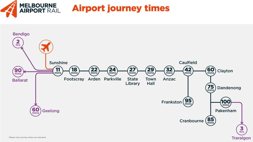
I meant to write this back in November: amongst the information published with the Airport rail link announcement was this diagram summarising the indicative journey times:
I think there’s a couple of interesting things worth noting here:
Airport to City
The anticipated travel time from the Airport to City is 27 minutes, which is longer than the theoretical quickest 22 minute trip on Skybus to Southern Cross, but shorter than the more typical 30+ minutes when the roads are busy
(Skybus no longer boldly promises any specific travel time, though they mention on their FAQ page that “in general” trips take 22 minutes. They also say it’s longer “during peak times”, their definition of which covers 8 hours per day.)
But for most people, Southern Cross is an interchange, not a destination. In fact for changing from Skybus to trains, it’s a really inconvenient interchange.
For people heading to most parts of the CBD, being dropped at State Library Station in 27 minutes or Town Hall Station in 29 minutes (hopefully reliably) is actually very competitive with Skybus.
In fact I suspect for most journeys to somewhere other than Southern Cross and the western end of the CBD, the rail link will be faster.
Even if you add a minute for a stop at Keilor East/Airport West – which makes a lot of sense – it’s still faster than the end-to-end journey time with Skybus plus connections.

Metro tunnel journeys
The second thing of note is that the diagram shows the journey times through the Metro tunnel, because that’s the route the Airport trains will take – they will be some of the same trains that run the regular service to Cranbourne and Pakenham.
I’m not sure that expected Metro tunnel travel times have been published this clearly before.
Parkville to Caulfield in 18 minutes is a pretty speedy journey. In comparison:
- by car (timed at 10pm on a Sunday in the middle of a lockdown) Google Maps says 21 minutes, and a typical journey in daytime could easily be double that
- the quickest option by tram and train I can see is 36 minutes
- if you want to avoid interchange, on weekdays the number 3 tram from Melbourne University (a different spot in Parkville to where the station will be) to Caulfield can take almost an hour
Of course the travel time benefits of the tunnel are highest when looking at journeys to/from places that don’t currently have rail – Parkville, Arden and ANZAC (Domain). But that’s one of the key advantages of the project, alongside the rail network capacity boost, and relieving St Kilda Road trams.

There is a caveat of course: they are going to need to provide consistently high frequency service, all day every day, so that people can depend on it being a Turn Up And Go service with minimal waiting, no matter when they’re travelling – just like the St Kilda Road tram spine the rail tunnel is seeking to relieve.
Frequent service on the connecting routes is important too.
In fact to spend billions on a rail tunnel but not provide high frequency services would be like building a big school but then only filling half the classrooms.
Provided the services are up to scratch, the tunnel is going to bring huge benefits to inner Melbourne once it opens.
15 replies on “Metro Tunnel travel times”
The diagram also shoes that trains will take 7 minutes to go between Sunshine and Footscray, but in the Time Table the travel time is 9 minutes (with stops at Tottenham, West Footscray, and Middle Footscray). Does this mean that airport trains will run express from Sunshine – Footscray?
By the same token, the trains are going to take an extra three (or more) minutes between Caulfield and Clayton, so…?
Correction I think is very easy to spot: “there definition of which covers 8 hours per day.)” -> “their definition of which covers 8 hours per day.)”
PS I liked the analogy at the end :-)
@Michael, typo fixed, thanks!
Also, “building a big school but then only filling half the classrooms.” the only benefit I see is social distancing, even then…
I don’t know the distance from where the new 9 km metro line junctions with existing lines north of Arden and south of Anzac, but, assuming it’s a couple of km at each end, I compared the journey time along the new line with an equivalent length of the Fremantle line (Claremont to Fremantle) and the proposed Sydney Metro Bankstown line (Dulwich Hill to Punchbowl) and it seems to work out at about the same 14 minutes (though it should be noted that the Sydney and Perth examples each have one more station in the section), so it’s generally a metro standard performance for sure. It would help if PTV provided the station distances to help with this sort of calculation.
Interestingly, the map only shows two suburban rail lines (Frankston and Dandenong). I guess most commuters will need to change at least once to get from their home station to the airport.
I agree with you that the airport train frequency will be crucial. You don’t want to wait 20 minutes or 30 minutes for your connecting train – that would defeat the purpose.
No news yet on the cost of a ticket to the airport? You can bet they will scrap the 901 bus to force people onto the airport train.
Thanks for the comments Daniel. The chart is revealing for what it does not say as much as for what it does tell us. Clearly, the busiest lines on the network are the target groups for the project, and the focus on being able to get from Pakenham to the airport in 100 minutes, or Frankston in 95 is great leap forward. The listing of the stopping pattern in the MM1 section is also part of selling the project and it’s instructive to see the addition of the three regional cities on the chart, although the travel times are expanded to accommodate the time taken to change at Sunshine and wait for the next service to Geelong, Ballarat or Bendigo. The minutes given to these destinations seem to split the difference between immediately catching a train and waiting the full duration to the next one. The Melbourne Airport Rail website has another chart showing that Geelong trains will another paths to Melbourne via Werribee with an interchange for the airport at Footscray.
What it does not tell us is the journey times to other key points in the network, Lilydale for example which would take 60 to 90 minutes to get to Melbourne Central, depending on the time of day (ie. direction of travel in the city loop) and interchanges, plus another 30 to the airport; and Belgrave which might also be mentioned on the map as being about 90 minutes from the airport. However, the big omission is the north east quarter of the metropolitan area, in an arc from Broadmeadows around to Doncaster (ish), for whom rail will be a poor option, at least until many years in the future when the suburban loop is open for an east-west journey in what will be the final stage of that project. For those of us in that part of Melbourne, being close to the airport is a disadvantage with regards to the train network, and the closer you are the harder it seems to get there by rail. Broadmeadows, for example, which is 7km from the airport, would take 40 minutes to get to Melbourne Central with the required change at Southern Cross to the loop in the afternoon and then a change over to State Library, followed by another 30 minutes to the airport; a total of about 70 minutes.
To contemplate this is absurd when even the 901 bus can trundle over there in about 15 minutes. It’s not much better on the three adjacent lines going east: Upfield, Mernda and the Hursty line. For a long time after the airport train is running it will be quicker to get the Skybus Eastern Express service (calling at Watsonia, Doncaster, Box Hill, Blackburn, Ringwood and Croydon) particularly from Watsonia and Doncaster. It’s only 30 minutes from Watsonia to the airport for example. For these north eastern suburbs private cars will remain the best option for some time into the future.
You’re on the money about Southern Cross currently being not a destination but an interchange for airport travellers. The two new central CBD stations will deposit visitors and tourists where they need to be – in the centre of lots of CBD accommodation, allow interchanges for locals, and carry others off to the eastern suburbs. The obsession by some observers with the “speed” of an airport train service always puzzled me too. It speaks really to the needs of business travellers who perceive that they need to be somewhere quickly, but fortunately the whole project seems to have considered the widest possible ridership and in a way that connects the rest of the network. The north east (and Airport West) not withstanding.
Wondering about the plans for overnight services Sunday – Thursday. I once got a very delayed flight back from Auckland on a Sunday night. It was too late to take any trains, but at least Skybus got me back to the city. Would they terminate at Westall in the early hours given it’s the first stabling facility on the Dandenong line out of the city? Could night network be extended to 7 days a week by then anyway?
I would think only Sunbury trains will stop at Middle Footscray, West Footscray and Tottenham – so a change at Sunshine for the Airport will be needed.
With trains from the Metro Tunnel travelling to both Watergardens/Sunbury and the Airport, does this make the turnback at West Footscray a white elephant, or would there still be trains terminating there? Maybe Airport trains won’t have a peak, so excess trains from the tunnel need to terminate at West Footscray?
I’m guessing that the walk-time from Town Hall to Flinders Street, which is the ‘hub’ for quite a few suburban lines, is about 5 or 6 minutes. So that makes it around 35 minutes to Flinders Street, which would have been nice to see on that original graphic.
@Lachlan, interestingly the Sunshine to Footscray timing in peak is 9 minutes, though that’s largely due to congestion on the line and allowing plenty of time so they don’t run late. That might not be a factor at other times of day.
Also coming into play would be the better acceleration of the Evolution (HCMT) trains over Comengs, though historically they’re not very good at taking advantage of better train performance.
There’s also an oddity with the Caulfield to Clayton – the diagram allows 18 minutes, but the actual time in the current timetables is 13-14 minutes.
@TonyP, the 9km includes the sections at either end connecting through to South Kensington and South Yarra (though metro tunnel trains will stop at neither). The next stops either side are at Footscray and Caulfield (so 24 minutes to cover roughly 17km including the ground level sections)
@Roger, the metro tunnel route has the advantage of Airport trains connecting with every other Metro train line at either State Library/Melbourne Central or Town Hall/Flinders Street, unlike Skybus which doesn’t connect to the Sandringham line, nor to Alamein/Blackburn (pm peak) and Glen Waverley (am peak). Stops at Sunshine/Footscray also mean it connects directly to every V/Line route except Seymour (but those passengers would do better to use the 901 bus)
There’s no reason to believe the 901 bus would be removed. It mostly serves airport trips from the northern suburbs.
@David, my understanding is that the Werribee route will only be used for *some* Geelong trains, in peak only. Effectively it becomes an expres track used alongside the Wydham Vale/Sunshine route.
You could put everything else on the network but it wouldn’t be a simple diagram then. At least this allows people to calculate what their journey times would be from anywhere, connecting in the City or elsewhere.
Yeah, it’s hard to see Broadmeadows/Upfield/Mernda line passengers using Airport rail. 901 bus, and eventually (if ever built!) SRL is a much better option. Those local trips (which would be very common for the huge numbers of airport workers) are why better local buses and an Airport West station are important.
@Nick, good question. Unclear at this stage. Overnight works can mean a 24/7 train system is difficult. Perhaps the Sydney model, with shadow buses overnight, is a better aim.
@Steve, bear in mind the timing. The tunnel is timed to open 2025. Airport Rail is perhaps 5 years behind it. The turnback will be useful in the meantime – though you can’t help thinking it should have been built at Sunshine, so short term that major destination gets more trains, and longer term it can be used to separate Airport and Sunbury trains there.
@Brian, true, the interchange times may be quite lengthy at some stations. Hopefully none of them are as bad as Southern Cross Skybus to train!
I am going to like these HCMTs even less.
The Comeng trains, have a comfortable acceleration. It is a negative if, one must now start being flung around due to acceleration that is too fast for comfort.
Those rail-replacement buses, I swear, I almost broke my writs trying to ‘hold on’ as it negotiated the traffic. The Xtrapolis trains had a superior acceleration too, but had to have that cut back, thanks to the injuries people gained from that.
@David and @Daniel – if only the 901 Smartbus intersected with the Upfield line! For those of us living in Brunswick, Coburg or further north, the only way is to get across to the Craigieburn line somehow, the train to Broady then 901, or go into North Melbourne, back out to Broady then 901. This takes over an hour.
The route of the 901 bus even looks like it’s going out of its way to avoid the Upfield line by through Coolaroo, and then running parallel to (and thus duplicating) the Craigieburn line to Broady. Extremely frustrating!
@Rad, it’s high time the Upfield line got a station at Camp Road.
[…] platform is for westbound trains (towards Footscray, Sunshine, and then Sunbury and from 2029 the Airport), and one platform is for eastbound trains (towards Parkville, the CBD, then out to Caulfield and […]