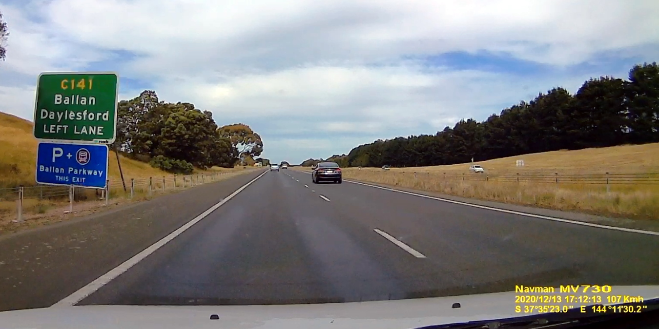
Along some of the main freeways coming into Melbourne, you’ll spot signage for Parkway stations.
Ballan, Bacchus Marsh, Wallan, Lara all have the signs. Possibly others, I’m not sure.
This now outmoded branding originated with the Regional Fast Rail project.
Regional Fast Rail project
Back in the mid-2000s, the Victorian government was revamping V/Line, via the RFR project, which updated the infrastructure and the fleet, introducing the V/Locity trains.
The RFR project also brought higher speeds (up to 160 km/h) to the shorter distance (commuter belt) part of the network, from Melbourne out to Geelong, Ballarat, Bendigo, and Traralgon.
It wasn’t perfect. The Seymour line missed out on many of the upgrades. And they foolishly converted much of the Bendigo line to single track, slashing line capacity.
But the project helped bring much of the infrastructure up to modern standards. And while splashing the cash on infrastructure, they were sensibly planning service upgrades to help boost patronage.
And so with the RFR project came beefed up timetables with better frequencies.
In 2007 they implemented fare price cuts. Most journeys got a 20% price cut, and some stations were pegged to zone 3 fares (Lara, Wallan and Melton Bacchus Marsh among them) which became zone 2 fares when zone 3 was deleted. The subsequent 2015 price cut has led to big discrepancies, with a journey from Melbourne to Lara ($4.50) being a fraction of the cost of a journey to the next station, Corio ($12.20 peak/$8.54 off-peak).
Alongside the fare cuts was the rollout of Myki. It was repeatedly delayed, but once finally running, made it far easier to catch a V/Line train within the commuter belt without having to first queue to buy a ticket.
Parkway stations
Aside from timetables and fare changes, they introduced the parkway stations.

The Parkway name appears to have been an idea picked up from the Brits. British Rail first opened Bristol Parkway station in 1972 -actually named after the nearby M32 motorway known as the Bristol Parkway, not originally a reference to park and ride, though it quickly gained that meaning as more of them opened).
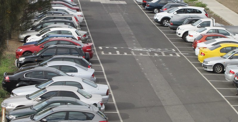
The Victorian Government expanded car parks at a number of stations, and branded them Parkways – putting these signs on the motorways to attract motorists driving towards Melbourne.
“Parkways are designed to relieve congestion by making it easier for travellers to park their car and connect with public transport services.”
Features of the new Bacchus Marsh Parkway include:
Upgraded and extended car parking; and
Victorian Government: 160 Extra Car Parking Spaces For Bacchus Marsh Parkways, 24 January 2008
New roadside signage

In terms of the strategy of a wide range of improvements, there’s some logic here – and you’d have to say the mix of measures to attract passengers actually worked – 2020 is obviously an exception, but in recent years, V/Line patronage has gone through the roof – from 11.3 million passenger trips in 2004-05 to 25.9 million fifteen years later.
When you introduce new faster trains, improve timetable frequencies and cut fares, you get more passengers. Who knew!
Parkways: UK vs Victoria
There’s a key difference between Victoria’s Parkway stations and the originals. In Britain they’re usually new stations – built on existing lines, where land is available for car parks, and near motorways. Sometimes they have been opened on the sites of former closed stations. But they haven’t been applied to stations in the middle of towns. The idea seems to be to avoid adding to traffic levels in towns.
V/Line’s parkways didn’t do this. They took existing stations, in existing towns, and expanded their role for park and ride passengers.
Britain’s parkway stations also tend to have far more train services than V/Line’s – though January’s timetable changes will be a good upgrade in the right direction.
As I’ve written many times, park and ride in urban areas is very problematic. Rather than expand the public transport network into car land, it does the reverse, often resulting in traffic snarls in local suburbs, and undermining feeder buses, walking and cycling and efficient land use. It’s also extraordinarily expensive, and no expansion ever quashes the calls for more.
But park and ride is defensible in regional and urban fringe areas where land is cheap, distances to reach the stations are often impractical by walking or cycling, and low density populations make good feeder buses less viable.
Whether the current locations of V/Line’s big station carparks are right, or whether these “Parkway stations” add to a long stream of town traffic, is a good question. It might vary site by site – just as it does for Metro’s station car parks.
So how are Victorian “Parkway” stations different to other stations with car parks? They’re not really.
It’s just branding, which is why you won’t find many references to Parkway stations around the place these days. Just the old signs on the freeways.
9 replies on “Victoria’s Parkway stations”
At Cheltenhgam LXRP eliminated the western (Bayside) parking and drive through drop off, removed the car park on the East (Kingston side) and blocked the drive through, saying “equivalent” multi story car park would be built- not yet started. Meantime Bayside eliminated all day parking west of Southland, even on one side of wide streets where all houses have side driveways. Bayside set about blocking all access to Southland station as part of their failed plan to eliminate 3 story apartments near Southland station. DEWLP rejected this however Minister Jacinta Allan and LXRP continue to oppose access to Southland and Shared Use Path extended to Southland and over Bay Road to Highett and the future Sub.Rail Loop station. The result is Southland underutilised, no safe bicycle, mobility scooter or pedestrian access, very few ‘Drop offs” and far worse traffic congestion. Time for PTUA to speak up in the public interest.
Fraser
Another “parkway” station is at Drouin on the Gippsland Line despite being further out than the other “parkway” stations
It would be of benefit for Regional Roads Victoria to place “Parkway-like” signposting on the Midland Highway at Epsom – pointing to Epsom station and car-park.
It would be a reminder to locals and those passing through that they can access a train to the big smoke from Epsom.
“Parkway” is a loaded term in urban planning because of the fight in New York City between the freeway builders, led by Robert Moses, and those who opposed them, the best-known of whom was Jane Jacobs. In the NYC context, a “parkway” was a type of freeway deliberately engineered for cars, e.g. with insufficient clearance for buses. They tended, for example, to allow middle class people with cars access to the beach, while excluding the working classes except for the purposes of demolishing or dividing their neighbourhoods.
As such, it was an odd choice here. I can imagine it was being consciously used in the UK, whose suburbs and smaller towns are astonishingly pedestrian-hostile, apparently on purpose. But one wonders how it got all the way to ministerial approval with no-one knowing the history of the term.
More generally, blindly importing transport strategies from the UK is perhaps not something we should be doing. They have found, for example, that they simply cannot build long-distance commuting into London fast enough to keep up with demand. Sound familiar? (Singling of the Bendigo might have been perfectly all right if the purpose of the line was to allow people who lived and worked in Bendigo good access to Melbourne for occasional special trips.) I would be happier if we took ideas from places which do not have extreme regional imbalances exacerbated by transport policy.
@Fraser, construction of the new multi-storey car park at Cheltenham is, sadly, very much under way.
I recall a while back (a fair while, actually!) when the 174th study in to a Rowville rail line was released that there was a station on Wellington Road where it intersected with Eastlink. Nothing was within walking distance of that station at the time, and there still is not, and this station was labelled as “Rowville Parkway”.
@Fraser of my memory serves, the people of Pennydale we’re very vocal in making sure that access to their neighbourhood would not be established to the station, to keep the quiet vibe. Sounds crazy to me but if that’s what they want then that’s what they want
When i moved to Lara in 2007 the carpark was small. On becoming Lara Parkway it attracted more Geelong residents, and cars were all over the area. The carpark was twice expanded, hugely, and pre-COVID was often full. Now, there are heaps of empty spaces. Will it ever be like it was 2019?
Bruce: Maybe repurpose part of that space for bus connections, and reserve the rest for possible expansion of the station?
I reckon the station parkings aren’t always a bad idea – just don’t let it become the permanent solution. It would be one way to reserve space around the station in the interim while surrounding areas develop. Once population levels are viable enough to run buses, repurpose part of the carpark for bus bays. Once the area gets sizable enough, then repurpose more of the carpark space to built denser housing, shops etc. Alternately, set aside part of the carpark for station expansions, so that additional tracks/platforms can be added for, say, local “Geelong Metro” trains vs “Geelong-Melbourne” express.