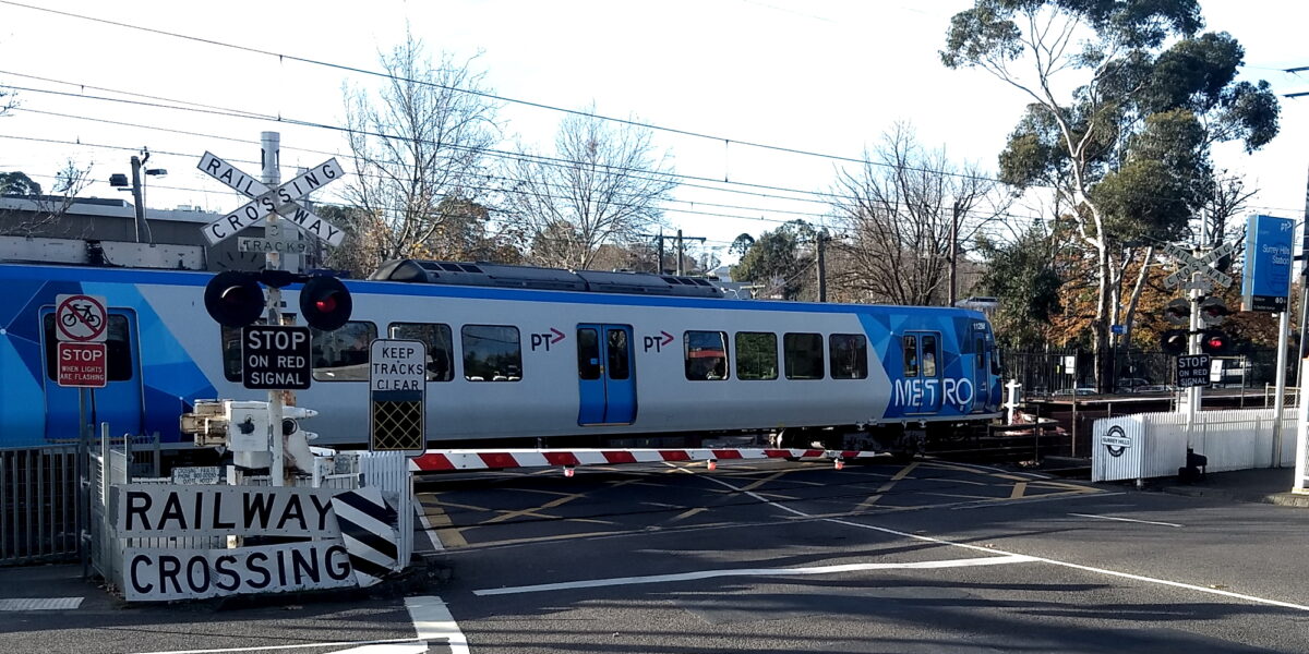
A little bit more on level crossings.
Since I posted the update, I’ve received some useful corrections, which I’ve applied to the list.
But last week there was an interesting update on some of them.

Pakenham line to be extended
The Pakenham crossings will be skyrail – we already knew that. But there’s an interesting twist to the design.
Pakenham is the end of the Metro line, where trains layover between services, and also sees V/Line trains coming through. This causes delays for the latter.
Meanwhile, the new HCMT fleet for the line is stabled at a new depot, a few kilometres further out. Which means the overhead wire already goes as far as the depot.
Rather than build additional platforms at Pakenham, which would complicate the skyrail design, they’ve decided to instead build an additional station at Pakenham East, where the Metro trains will terminate. Extra tracks there will allow V/Line trains to easily get past them.
This will also serve a new housing estate nearby – though it seems the current structure plan doesn’t yet take into account the new station.
Overall this seems to be very smart planning – resolving a number of problems by thinking outside the square.
Surrey Hills and Mont Albert
Potentially more controversial: removal of the level crossings at Surrey Hills and Mont Albert was always going to be tricky, because modern standards dictate straight platforms, and the current locations of the two stations are on curves.
Gradients in the area (the clue is in the names of the stations – Mont meaning mount) also complicate things. Skyrail isn’t really an option, and retaining a station at Mont Albert below street level would require, they say, “a daunting 12 metre climb from platform to ground level”.

A 1970s plan involved demolishing half the suburb to extend Warrigal Road over the railway line. That plan, understandably, got enough pushback that it never happened.
The 2020 plan, given that Surrey Hills and Mont Albert stations are only about 800 metres apart, is that they will merge them into one station, on a straight section of track between.
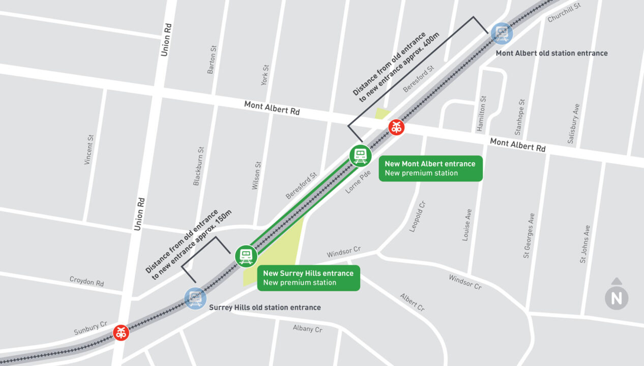
The new combined station will have entrances at both ends, making it about 150 metres from the existing Surrey Hills entrance, and about 400 metres (including across a main road) from Mont Albert.
Closing/merging stations is a first for the Level Crossing Removal Project. Other sites have seen station locations move slightly (such as at Hughesdale, where the station swapped from the east side of the road to the west) but until now, none have involved reducing the overall number of stations.
The government says a rewrite of the Belgrave/Lilydale line timetable will result in more peak trains stopping at the new station, which presumably means better service, particularly for current Mont Albert users.
The project is going to need to provide good quality walking and cycling paths to the new station, but a few other questions spring to mind.
- How will the Hamilton Street shopping centre (adjacent to Mont Albert station) survive given it’s about to lose a chunk of its walk-up patronage?
- Will the traffic lights to cross Mont Albert Road (between the old station/shopping centre, and the new station) be programmed to be very responsive to pedestrians and cyclists, or will it be the standard Melbourne practice of leaving them waiting for ages for traffic?
- Will the new rail alignment have provision for a future 4th track? One day this is going to be important to cater for express trains in both directions.
- Possibly the least important issue here: what to call the combined station? (One wag’s suggestion: The Full Monty)
- Will the Robinson Road underpass stay? It’s one of Melbourne’s lowest clearance bridges, fortunately on a side street (see below) – less than 400 metres from where the rail line will dip under Union Road. A handy shortcut for pedestrians, despite it having no footpath, but arguably less important for vehicles once Union Road is crossing-free.
- And what do the locals think of all this anyway? Apart from concerns about the shops, and one bloke on the news who wasn’t sure he wanted a railway station on his doorstep (I’m sure he’ll be happy enough once his home value starts rising), I’ve barely heard a peep.
This is the Robinson Road underpass (2.5m clearance), which is about 370m from Union Road, Surrey Hills, where the railway line will go under the road.?
— Daniel Bowen (@danielbowen) December 9, 2020
I’m speculating, but I would guess this underpass won’t be here once the project is completed. pic.twitter.com/wlHqnaudnu
Multiple entrances
Entrances at both ends of the new combined Surrey Hills/Mont Albert station will definitely help the locals easily access trains.
It would be nice to see a lot more stations provided with multiple entrances. It brings a lot of walkability benefits, and it’s minimal cost (especially when rebuilding stations) but – apart from those added to cover for slow Myki readers – trying to get more than one entrance/exit per station is like pulling hens teeth.
As for merging stations, it’s understandable why they’ve chosen this design, to overcome some genuine engineering challenges. But I absolutely wouldn’t want it to become a regular pattern.
- LXRP: Pakenham project update and community engagement
- LXRP: Surrey Hills/Mont Albert project update and community engagement
- Peter Parker on the local bus connections
24 replies on “One station added, one station removed”
I don’t know about not merging stations. I’ve long thought they should merge Anstey and Brunswick stations if they end up sky railing the southern part of the upfield line. They could put exits on Hope and Victoria streets and not lose much walk up traffic.
I think there is a case to look at merging stations, some of them are very close and can be addressed with multiple entrances with minimal passenger access impact as you mentioned. This would make rebuilding stations cheaper (one instead of two) and improve travel times.
For the Belgrave/Lilydale line, adding the fourth track will require rebuilding the stations between Surrey Hills and Burnley to straighten tracks and move platforms to the outside tracks. Canterbury and Chatham stations, which are only 500m apart, could be merged with a new station moved as far west from Chatham as the straight section will allow, with entrances at either end (the main issue will be the need to cross Canterbury Rd to get to the Maling Rd shops from the western entrance).
Similarly, Glenferrie and Auburn could be replaced with a new station adjacent to Central Gardens next to Swinburne. Ramps accessing either end of the station could provide short walks to each of Glenferrie and Auburn Roads. And finally, if the Alamein line were to be converted to light rail (and extended to Chadstone), a new light rail stop can allow for East Camberwell station to be eliminated altogether (with the downside that east-bound passengers would need to travel back to Camberwell).
In this way, 3-4 stations can be eliminated with nil to minor impact to passenger access, reducing cost and speeding up services. If this were to occur, you could then consider having dedicated express services from Box Hill to Richmond without needing to stop at Camberwell or Glenferrie, since changing to these services at Box Hill will have less of a time impact than today.
Merging stations? Presumably Ormond-McKinnon-Bentleigh are exempt from this discussion, now that they’ve been rebuilt?
There’s already quite a long distance from Mont Albert to Box Hill, so there’s going to be an even longer gap between the new station and Box Hill.
Presumably the new station will need to be level (as well as straight)? The climb up from Surrey Hills to existing Mont Albert is quite significant but if the railway is lowered at Union Rd, and the new platforms are to be level, I wonder whether access to the new station at the Mont Albert Rd end is going to be much less than the “12 metre climb from platform to ground level” given as one of the reasons for not rebuilding the Mont Albert station.
I think the station merging is a good thing as there are a few stations that are too close together (ie less than 1km distance). These two stations were separated by only less than 700m and Chatham is only about 700m from Surrey Hills. As long as the new station is in a central location (which it is), there shouldn’t be too much downside besides a few hundred metres extra to walk.
One thing i’d also like to see from the new Pakenham East station is the Pakenham railway line retain its current name. I find it a bit of a waste of money and a bit confusing too when as soon as they extend the line, they rename it to the terminus stations name.
I think with the naming of lines, the rule should be that the name of it reflects the locality of where it travels through not necessarily the locality of the terminus. A good example of this the Joondalup line in Perth which now terminates at Butler, but has retained its name.
Another pair of stations that I’ve seen discussed for merger are Hartwell and Burwood… Build a new Burwood station at the highway bridge, so that it can better connect with trams etc!
Understandable change, though a small shame as Mont Albert station is a joy to enter on the citybound platform. Street level, you can be picking up a coffee next door and see the train arrive and walk straight on.
Hopefully the new station isn’t surrounded by a large car park, and really links well by foot and bike to both Union Rd shops in Surrey Hills and Mont Albert Village.
One factor I don’t see discussed as yet is the width of the road where Mont Albert Rd or Union Rd will cross the new trenched tracks. Hopefully sufficiently future-proofed for decent sized footpaths and segregated bike lane. Right now these feel spacious (as they’re level crossings), and no space should be skimped here above the line, especially for people on foot.
In terms of adding entrances to existing stations, there a number of easy opportunities out there, but for starters, I think stations like Richmond should just have their stadium end entrances open at operational times rather than just on event days.
On the Surrey Hills / Mont Albert plan…
Removing the Mont Albert Road level crossing and Mont Albert Station driving all the foot traffic over an extra Mont Albert Road pedestrian lights/crossing (there’s one just 150-200 m east already) seems pretty silly. How frequently will traffic be stopped for the former Mont Albert passengers all needing to get to the new station entrance on the other side of Mont Albert Road. Surely a pedestrian overpass (to cross the trench and then a Mont Albert Road underpass on the new station entrance side) should be included.
I doubt there is enough space between Beresford Street and Lorne Parade for 3 generous future proof platforms and the 3 tracks. Narrow platforms at Surrey Hills are already a crowding and safety issue. I can’t see space for 3 platforms wide enough for patrons of both the current Surrey Hills and Mont Albert Stations.
Are they going to provide special parking for PTV maintenance vehicles somewhere in the scheme?. Since taking up their normal maintenance staging area with new Surrey Hills substation at the east end of the south car park, PTV and contractor works vehicles are routinely closing significant chunks of the remaining precious public car parking space for works staging. Maintenance staging needs should be considered separate from disrupting patrons with car park occupations.
Not being able to get a park after 7:15 or so in the morning is the biggest customer experience issue at Surrey Hills. Not sure the scheme appears to attempt to address this problem – only saying number of car parks will not be reduced. They already have reduced parking by cordoning off of the “bush parking” area opposite the corner of Beresford Street opposite Wilson Street).I doubt anyone know how many parking spaces are actually at Surrey Hills. The north side parking is only partially marked and the south side parking is unmarked – random parking is rife (an issue that has been complained about for 30 years or so). Modernising car parks will always reduce the number of parking spots to some extent. But it should be better than being blocked in by a random parker.
Will zone 1 be extended to Box Hill finally or will it be truncated back to Surrey Hills. It currently ends at Mont Albert causing a significant volume of Surrey Hills patronage from passengers from the east driving in to get to zone 1 rather than using Blackburn and Box Hill. I’s argue zone 1 should extend to Blackburn spread the load better.
@Paul, they will need to think carefully about the line names anyway when the Sunbury line and the Cranbourne/Pakenham line become one.
@Wallfly, making people cross the road isn’t brilliant, but even the most favourable (to pedestrians) programming is nowhere near as disruptive as an unpredictable busy level crossing.
Regarding platform widths, presumably you’re across the detail of Lorne Pde becoming one way and part of Beresford St closing.
I’m not sure what you mean about extending zone 1. Since 2015 zone 1+2 fares have been capped at zone 1 prices, so there few people would drive from Blackburn or Box Hill to Surrey Hills to catch a train, especially with the less frequent service.
Indeed, since the change, patronage at Surrey Hills has dropped by 12%, and Mont Albert 19%. https://www.danielbowen.com/2019/09/23/zone-changes-affected-train-patronage/
According to https://engage.vic.gov.au/lxrp-surrey-hills-and-mont-albert , on the feedback section – there *won’t* be space for an extra, fourth track.
“ to fit the three tracks into the trench we already need to modify Lorne Parade and Beresford Street. Adding a fourth track would be difficult to achieve without compulsory acquisition and the advice we’ve received about the future needs of the network indicates a fourth track isn’t required.”
Probably makes sense to keep the Pakenham line name, as that is effectively the town centre. Similar to what happens with the regional lines – they’re still Geelong, Ballarat and Bendigo, not Waurn Ponds, Wendouree, Eaglehawk/Epsom. I’ve always found it a little interesting that the V/Line conductors announce Geelong as ‘Geelong main station’, to distinguish it from the terminus further on.
On a side note, after four months at home I’ve been back to Geelong in the office for the last two days – had my Myki checked on the outbound Warrnambool service yesterday morning (for the first time since the pandemic started) – which was disappointing because I forgot to touch off and had to pay the peak default fare!
@Daniel
Thanks for the heads up on the Zone fares.. I’ll discount that from my arguments.
On parking… need to note that Beresford Street and Lorne Parade are currently both used for on-street parking all the way between Surrey Hills and Mont Albert stations. At a guess it could be 150 spots all up. I’ll reserve judgement on the changes until some detail of how many of the current car parking spaces in these streets are also to go.
The artist impressions don’t show many cars and some of the existing Surrey Hills car parking is colored in for other purposes. I can’t see how they can claim that the level of car parking will be maintained.
Maybe some cut and cover to join up the north and south side car parks at Surrey Hills could be considered.
As I’ve comment in the past on your site taking the bus to get to this my local station doubles the typical commute travel time (station to station).. but the bus is never on time.
I’m not against the proposal, but would like to see real solutions for addressing car parking in terms of real numbers. After all it the #1 customer experience issue with the current set-up (for those outside the 15-20 min walk to the station zone).
On the artist impressions… let’s get some more appealing design influences other than the garish industrial chic that we are served up in Melbourne. C’mon architects of Melbourne step up! We once were Marvelous Melbourne. Surely the new station doesn’t have to be another garish industrial chic mess (Laburnum, Blackburn and Mitcham stations are ghastly).
I did hear people say that, this new combined Surry Albert station, may be more like Laburnum, with no platform on the middle track???
Ignoring the location of the level crossings themselves for the moment and the grade changes and “track straightness” between them (and therefore the implications for above / below ground and precise station alignment etc) , i would have thought that from a purely spacing perspective, it makes more sense to combine Surrey Hills and Chatham stations given Canterbury – Chatham – Surrey Hills – Mont Albert are about ~800m apart each and in somewhat pedestrian friendly streets, whereas Mont Albert to Box Hill is already 1.4kms – and somewhat pedestrian hostile. Combining Chatham / Surrey Hills results in a very even 1.2-1.4 km spacing for the stretch Canterbury to Box Hill – as opposed to the as proposed 800 – 1.2km – 1.8km for Canterbury – Chatham – “Mont Surrey” – Box Hill. Combining Chatham / Surrey Hills would produce a better bed-shed outcome i believe.
Obviously, the initial practical considerations around grade, track straightness, level x-in’s themselves etc cannot be ignored, simply suggesting spacing seems to have taken a substantial back seat here.
@Expat Merging Hartwell and Burwood stations would have the additional benefit of freeing up the “Burwood” name for the SRL station! :p
@Andrew There is no doubt consistent spacing has taken a back seat, which is not a great thing in my humble opinion. Presumably the need to remove LX’s was the priority, and the ‘better’ solution was the merger of Mont Albert & Surrey Hills. Hopefully some future consideration will be given to merging Canterbury and Chatham – if station mergers are under consideration. Chatham has very little use and no parking, and, IMHO could be moved westwards and combined with Canterbury – which would allow spacing of around 1800m to the new Mont Albert/Surrey Hills station
[…] The maps will have to be redone around that time for the Surrey Hills/Mont Albert merger […]
The obvious name for the station is “Union” (but it might be politically unpopular.
I don’t think that the local will hear about the station merger with the local papers the Progress Press and the Whitehorse Leader not being printed anymore. However, the 766 bus that travels past these stations doesn’t carry many passangers. The car park at Surrey Hills station is full alot of the time, so will all the parking at both stations be kept.
With what others have said, it might be better to merge Surrey Hills and Chatham Stations with a new station west of Union Road and a new Mont Albert Station closer to Box Hill. Also asking if the new station will be ready for four tracks, the stations east of Blackburn are not prepared for three tracks to go from Blackburn to Ringwood. Only two tracks go through the bits dug out.
The merging of Hartwell and Burwood Stations with a new station at the tram line would be good. Also the Suburban Rail Loop will have a station at Burwood to take the name Burwood Station.
[…] Metro Train services will be extended to closer to the depot, with a new Pakenham East station, which will also serve nearby housing. This will allow them to rebuild Pakenham as an elevated station above the road, without complicated stabling and V/Line passing tracks, to remove the level crossing there. […]
In true LXRP are not releasing all the details on building sizes https://www.change.org/p/release-images-of-union-station-building-planned-for-mont-albert?utm_source=share_petition&utm_medium=custom_url&recruited_by_id=4d862d10-2f09-4d4d-b7d1-436a7b7f8e25
Union Station should be called Mash Station to clarify Mont Albert Surrey Hills.