There have been rumblings for a while that some of the level crossing removals might include elevated sections, but finally we have a concrete (pardon the pun) proposal to look at: the crossings along the Dandenong line, known internally as “CD9” or the “Caulfield To Dandenong Nine”. (Sounds like a music group.)
It’s become more popularly known as “Skyrail”.
The “Skyrail” name seems to have originated either with a journalist or an Opposition MP, as it first appeared in this Herald Sun article in January. I checked with the journo, and he’s not sure — it may have been the work of a subeditor — but certainly the name has stuck.
Since then the Government (MPs at least, not necessarily bureaucrats) seems to have tried to embrace the nickname rather than ignore it, and it’s handy shorthand.
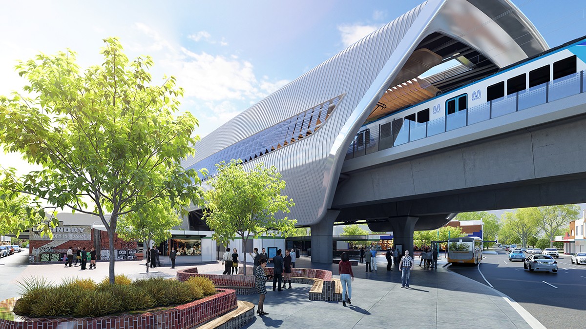
Carnegie: current and proposed
So, what do we know?
Pulling together the information provided publicly and more gleaned from discussions with the Level Crossing Removal Authority (such an unwieldy name; LXRA for short), here’s what I’ve learnt about the project.
It’s three sections of elevated track:
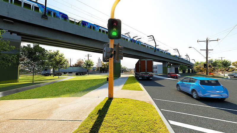
The first section will go up and over Grange, Koornang, Murrumbeena and Poath Roads, incorporating new stations at Carnegie, Murrumbeena and Hughesdale. This is probably the most controversial section, as it is very close to homes, due to the narrow width of the rail corridor.
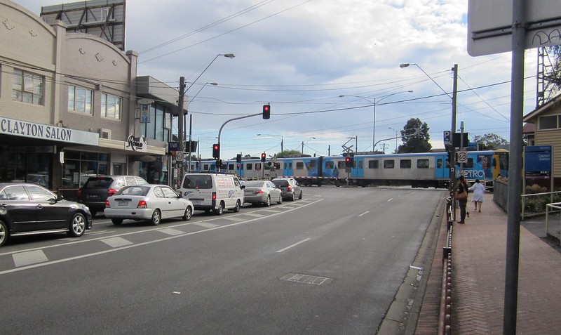
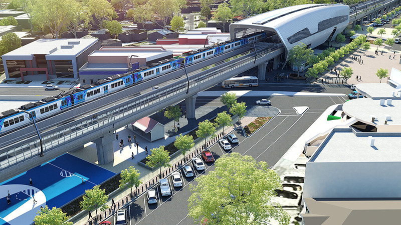
The second section will go over Clayton and Centre Roads, including a new station at Clayton.
The third section will go over Corrigan, Heatherton and Chandler Roads, including a new station at Noble Park — though they come pretty much down to ground level between Heatherton and Chandler Roads. Apparently a rebuild of Noble Park station isn’t really required to do the grade separations, but they’ve decided to do it anyway, to move it closer to the local shopping centre and provide new facilities at the station.
The height is mostly between 8 and 10 metres. This is well above the 5ish metres required for road clearance, because they want to maximise light underneath the structure and into neighbouring properties. For the same reason, most of the way along, each track will be on a separate structure. It also helps assists with construction while the existing railway and roads stay open.
The extra height should also help prevent any nasty incidents with trucks hitting bridges.
Light and shadow is important issue. Minimising shadow impacts can help with growing vegetation underneath, which will make it more pleasant.
It also makes a difference to nearby residents, particularly between Caulfield and Hughesdale where some houses are very close to the line — though of course it doesn’t even come close to eliminating the impact. More on that later.
The LXRA have got a 3-D model showing the light and shadow at different times of day, using the sun’s position on 22nd September — which is apparently the standard.
The new stations won’t straddle the roads. Exits will only be on one side. This seems a shame, though most of the roads (currently) are only 4 lanes total, unlike at Nunawading or Ormond (which have got or are getting exits on both sides). I suppose sticking to a single exit may help with sight lines and personal safety.
With platform level being up to 8-10 metres from ground level, access becomes important. I’m told each station will have lifts, stairs and escalators. They will all be island platforms, which is good for safety, maximising space and access to station facilities.
So what about bus interchange? Most of the new stations would be on the eastern side of the main roads (Hughesdale the exception, it would move to the western side of Poath Road) so southbound bus stops will be on the road, next to the station entrance.
Northbound? Well it seems (at Clayton and others, it appears) they may loop around via an access road, to avoid passengers having to cross the main road. Hopefully that doesn’t add to delays too much — an opportunity there for traffic light priority. Yes, it’ll be faster than long waits for boom gates, but will it be as fast as it would be sticking to an unencumbered main road?
Update: Additional diagrams have been released that show a number of bus stops being across roads from stations (as well as other detail). This needs further explanation.
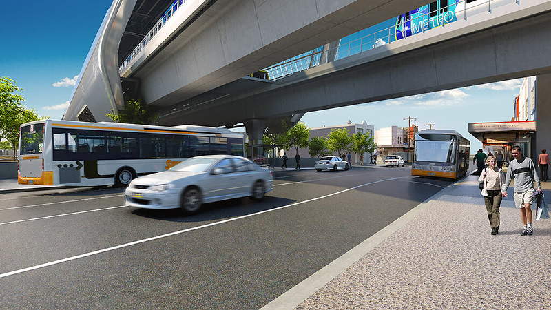
Centre Road, Clayton: current and proposed
The line will stay as two tracks with “passive” provision for extra tracks — the project will be in line with a longer term plan for two additional tracks later. Elevated instead of in a cutting apparently makes this substantially easier, as expanding a cutting is difficult without shutting down the line.
Edit: It’s assumed that the two extra tracks later will be for freight and express services, therefore they don’t need platforms at most stations. See also the section on Capacity, below.
The promise: reduced disruption during construction — it’s widely known that there are huge disruptions when putting rail lines under roads, particularly when there’s very little space alongside the existing line.
For some (eg Gardiner, Springvale) they can do a lot of the construction alongside the existing corridor, and minimise shutdowns. But for narrow alignments that’s difficult. The Ormond to Bentleigh project will have something like 10-12 weeks of shut downs in total, covering numerous weekdays including peak hours.
Running buses (properly!) in peak hours is a huge operation. The recent late-January Frankston line shutdown used around 100 buses at times, and huge numbers of support staff. And that was outside university term times, so the loads were less than there will be for the big shutdown this winter.
The Dandenong line is far busier than the Frankston line, so longterm bustitution really wouldn’t be pretty, particularly as they want to push ahead and get the whole project built within three years.
The LXRA says the Skyrail design means much of the disruption can be avoided. A lot of the structures can be built around the existing infrastucture, including building some off-site. Estimates, subject to change, are that there will be perhaps 15 to 20 weekend shutdowns, with only two longer shutdowns of around 9 and 16 days — I’d hope the latter could be contained to school holidays. (Edit: corrected number of days.)
If those estimates are correct, it’s certainly a far cry from the Frankston line shutdown this winter which is expected to be around 5-6 weeks long, only partly during school holidays — and the three stations themselves will closed for up to 3 months.
Clayton: current and proposed
Opening up public space. 225,000 square metres, they say, or the equivalent of 11 MCGs. When did MCGs become a standard measurement of land area?
There’s extra space for parks (worth noting that Glen Eira, covering the inner section, has the least open space of any metropolitan council area). In some spots there’s potential for existing parks or facilities (such as the aquatic centre at Noble Park) to be expanded under the tracks.
Seventeen extra cycle/pedestrian crossing points have been flagged — presumably this excludes the parks, which you could also walk through.
And five new rail/road crossing locations have also been identified with help from Vicroads and councils. Hopefully they don’t become semi-arterial rat runs, and shift traffic rather than creating more. My assumption is few if any of these extra crossing points would be economically viable if road bridges had to be built across the rail line.
An extra 12 km of cycle paths will be added, linking existing sections to make a single stretch for bikes from Caulfield to Dandenong, with local councils contributing additional links to Monash University and the Gardiner Creek trail, which provides an off-road path all the way into the city.
Urban slum? — Open space only works if people use it. As noted above, the LXRA’s claim is that by building the rail higher than needed, and mostly along separate structures, it maximises the light.
I’m not convinced by the assertion that such a space automatically becomes urban blight. Comparisons to existing elevated rail lines in Melbourne aren’t really fair, because they are decades old and haven’t been designed with these issues in mind. Comparisons to road overpasses are doubly unfair, as roads are wider, tend to be lower to the ground, and as with those older rail examples, haven’t been specifically designed for space underneath them.
If we avoided building anything that could attract graffiti, we wouldn’t build much, because just about any close-to-vertical surface attracts graffiti these days. That said, most of the structures near the ground are columns, so far less “canvas” than the retaining walls used on most past Melbourne elevated rail, as well as on most cuttings.
Any public space can become vandalised and littered. The question is how it’s minimised and managed. It could be good, or it could be bad. Will people feel safe there, or will they avoid it like the plague?
Perhaps local councils will take on the ongoing maintenance — then as with their other parks, then you’d hope these new spaces can be maintained to a similar condition. Hopefully the LXRA is thinking carefully through this.
Concerning is the pledge that the space will also be used to provide “thousands of new car parks” — I can understand why they might want to preserve the number of spots currently offered at stations, but a huge expansion of car spots is a terrible use of space, and will only encourage more cars into these busy suburban centres.
I can certainly believe that big car parks underneath the rail line might become well urban blight, much like the similar spaces underneath the Westgate Freeway.
Mile Creek — if rail is elevated, getting over the Mile Creek in Noble Park isn’t an issue. Otherwise there would have been some serious challenges doing this, especially with Chandler Road only a few hundred metres away.
The Coalition’s plan in 2014 did not include funding for Chandler Road — in fact it only included funding for removal of 4 of the 9 level crossings, with money to study the rest. Given their fierce opposition to SkyRail, I wonder if asked now, what they would say about how they would address Chandler Road? (The same goes for roads along the southern end of the Frankston line, near the Patterson River, for instance.)
Capacity — this project is part of the overall Dandenong line upgrade project. Level crossing removals enable more trains. Platform extensions (30 of them in all) will enable the longer “High-Capacity Metro Trains” that will be bought in coming years. The total is claimed to be a 42% boost to peak capacity, and that’s before any moves to high-capacity signalling. This project will include new conventional signalling.
That said, the longer trains can only be used once the Metro rail tunnel opens circa 2026, because existing CBD stations can’t handle them. There’s been no commitment yet on platform extensions for the Sunbury line, but that would also need to happen, as post-tunnel, the Dandenong line will connect to it.
But in the meantime, you can at least move closer to filling the line with trains (up from around 15 per hour now) without locking up the road system. And I think we all know the Dandenong line needs more trains.
(I’m awaiting an answer on precisely how many trains the new signalling will allow. The current theoretical headway is 3 minutes, at a maximum speed of 80-95 km/h.)
So in terms of extra passenger capacity, and new station facilities at five locations, there are some pretty good outcomes for train passengers.
Noise reduction — the LXRA are firm in saying that the noise from trains would be far less than with them at ground level. Noise barriers will apparently prevent most of the sound reaching ground level, and they plan to test them after installation to make sure they work.
They also claim vibrations from trains on the viaduct would be less than at present.
Rail safety — apparently it’s now a world standard for elevated railways to include derailment protection. Derailment beams will stop the train from falling off the viaduct if the wheels leave the track, so the effects of any derailment would be less than if it happened currently at ground level.
And the cost? There have been claims in the past that elevated rail is cheaper than putting it under roads. At $1.6 billion for the whole project, it seems reduced cost is probably not a benefit. The key difference seems to be that less of the money is going into disruption costs such as running buses, and moving underground services. (I stat I have written in my notes is that disruption costs can be up to 40% of the cost of a level crossing removal.)
Were the alternatives considered? I’m told yes, and they were significantly more disruptive during construction. And of course while debate rages, a big trench through the suburb might be “out of sight, out of mind”, but isn’t lovely to look at, and doesn’t provide many if any opportunities for extra line crossings of use of the space.
Local residents are angry
There’s no doubt you’d be angry if you lived next to the rail line, especially if you had no idea this proposal was coming.
Even if you accept that the noise from trains will be reduced, and like the benefit of the level crossing removals and extra pedestrian/cyclist/road connectivity, there’s a huge impact from having an 8-10 metre high railway next to your house. It will fundamentally change the feel of that part of those suburbs. So does a trench/cutting, as we’re discovering in Bentleigh, but it’s less visible from street level.
Currently you might look over your back fence and see sky and some electrical wires, and a train passing every few minutes. If this plan goes ahead, instead you’ll see big concrete columns, a high viaduct above your head, and trains going past.
Is the impact bigger than having it at ground level? Visually, of course it is.
But the impact is quite different according to exactly where you are. The LXRA is very keen for people to come along to the consultation sessions happening in the next few weeks, and/or to contact them for a one-on-one discussion.
They have got a 3-D model which shows the design, how it looks from all sorts of different angles, and where shadows are cast at different times of day.
And they’ll be asking residents what options they’d like to reduce the visual impact from peoples back yards, including building high walls, and trees. Obviously that’s only going to do so much.
Should we believe their claims about noise and vibrations? They’ve got some clever people, but I think they need to get better at presenting the evidence they have that it will be better with this project built and noise barriers in place. They should quantify the noise estimates. And prove afterwards that it worked.
They’re going to need to prove that privacy screens or other measures can successfully stop train passengers gazing down into peoples back gardens.
And there is a range of other concerns from residents that needs to be addressed.
If it were me
I’ve written before about living next to the Dandenong line, in Murrumbeena:
We moved into a flat just across the street from the Dandenong line. The noise isn’t noticeable after a week or two, apart from missing dialogue on the television when a freight train goes past.
My lasting memory is that the main impact of living by the line was the noise. The visual impact was that we saw the trains go by the window, but you get used to that, and eventually it’s meh, who really cares?
If the rail line was high up off the ground, then I’d have been looking out of the window at static columns instead. Assuming less noise and vibration, I personally think, in that context, I wouldn’t much mind. But we didn’t have a private garden to try and enjoy.
Everyone is different, every property is different, the impacts on each are different, and opinions are different. It’s very easy to see why residents are angry.
More info
- Locals should quite definitely attend one of the consultation sessions or contact the LXRA for a discussion
- Official information: Proposed designs unveiled for Caulfield to Dandenong corridor
- Definitely worth reading for the broader planning context: Urban Melbourne: Was the Dandenong corridor’s fate sealed with the new residential zone rollout?
- Residents along the Dandenong line opposing Skyrail have a petition, as do those on the southern end of the Frankston line
- Some good reading from Alan Davies on The Urbanist blog: Is the future of this train line up in the air? and a critique of the reporting on the proposal.
- Meanwhile, in the west: Kororoit Creek Road, Williamstown North (on the Altona Loop) is also planned to be an elevated rail soluton, but is less controversial because it’s not in a residential area. However it has been flagged that the rail line there may be closed for up to three months, which seems excessive. This may be subject to change.
Thanks for the comments so far. Keep them coming — I’ll answer those I can, and will try and get clarity from the LXRA on the others.
Update 12/2/2016: More detailed designs have been released of each site. This raises questions about the continuity of pedestrian/cycle paths and the bus stops (mostly northbound) in relation to where pedestrian crossings will be provided.

For instance in this image of Murrumbeena:
- One bus stops in Railway Parade — this would be the 624. The westbound stop is across the road from the station, with no nearby crosswalk.
- The 822 is moved entirely into Murrumbeena Road, which is good, but access to/from the northbound stop requires going south to the crossing there.
- They’ve actually put an arrow indicating the bicycle/pedestrian path from the west, but led it straight to the main road! Those people too would need to divert south to cross safety, and how do cyclists navigate the station precinct, particularly the car park, to keep heading east?
- The potentially impressive station forecourt doesn’t seem to face the way pedestrians would be approaching, mostly from the north or south along Murrumbeena Road, or from the east. Only bus passengers changing from a southbound bus (not likely to be as useful as other bus connections) would approach from that direction.
Most of the other stations are similar (only Clayton seems to propose the northbound buses running around the station). This needs clarification… and, it appears, some revisions to the design.
126 replies on “Skyrail!”
Wow – thanks Daniel. This is a really helpful article. I hope everyone involved reads it.
It’s very disappointing the stations don’t extend over the road (even just as a walkway/access point), for two reasons. The first has been outlined, that is, transfers to northbound buses, forcing bus detours, or otherwise pedestrians to wait for 2 or more minutes to cross the road (probably missing the bus in the meantime).
The second is the need for pedestrian crossings at the station location – whereas before the main traffic delays were boom gates, there’s still going to be constant traffic delays from pedestrians trying to access the station crossing the main roads via signalised ped crossings. The delay for pedestrians will be frustrating, and reduce the ped-shed on that side of the station (or leave it as is, when it could have been extended).
Any comparisons to Cut & Cover?
If the rail line went underground, parkland (and buildings) could go above the rail line and noise would be even less.
Downsides?
* They would need to cut the ditch for 4 rail lines now, rather than later.
* More Disruptions during construction
Bike paths on the surface will need to cross roads like the current train line does, this is a very poor outcome for cyclists, less so for pedestrians. Why is elevated rail being put forward as the final solution? Underground rail would cost more but have much less long term impact. A linear park can be built above it with bike and pedestrian paths and a mix of some residential and commercial buildings. Cities such as Paris, Stuttgart, Naples and Tokyo all have underground rail. If you want to how overhead rail ends up a disruptive divisive eyesore visit Canterbury Railway station.
I am surprised they are keeping all three of Carnegie, Murrumbeena and Hughesdale stations. From Carnegie to Oakleigh you will have four stations within three kilometres. This does reduce the volume of people crossing the road at any station. How many people live west of Murrumbeena Rd that wouldn’t use Carnegie station, for example.
Also, I would have thought extending through to Oakleigh and putting warrigal rd back at grade would have made sense as part of this project.
https://gfycat.com/WickedNewFlyingfox
Do it that way. It’ll be awesome to watch. You can sell tickets.
I’m an experienced skyrailer, as I live in Clifton Hill and we cruise at 30,000 feet (minus 29,970 feet) between West Richmond and Clifton Hill.
When I drive, those underpasses are a godsend. The tracks are busy enough that you can be caught for up to 4 trains in a row at the boom gates.
As a a pedestrian, the underpasses ARE ugly. But they were not designed to be anything else. If the tracks were higher, and more light came in, they could actually be acceptable. I think design matters here. I suspect there are many ways the area beneath the tracks could be made more human-friendly cheaply, using materials.
As it is, the area under Victoria Park station’s elevated crossing (4.3m high) is actually quite nice now with two busy restaurants locating there:
https://www.google.com.au/maps/@-37.7999338,144.9943633,3a,75y,263.3h,84.54t/data=!3m7!1e1!3m5!1sHViF26sMIvkiOnCj3Su9XQ!2e0!6s%2F%2Fgeo3.ggpht.com%2Fcbk%3Fpanoid%3DHViF26sMIvkiOnCj3Su9XQ%26output%3Dthumbnail%26cb_client%3Dmaps_sv.tactile.gps%26thumb%3D2%26w%3D203%26h%3D100%26yaw%3D56.086407%26pitch%3D0!7i13312!8i6656?hl=en
The other upside of skyrail that is little mentioned is the benefits for the passengers – terrific views, and superior phone connectivity. That won’t placate the residents but it matters for the passengers!
I hope this plan gets up.
This elevated rail line is a great idea and I’d be happy to live alongside it. I see a lot of potential for community-oriented use of the land it will free up in what is now an off-limits rail reserve.
I think people underestimate the cost and difficulty of doing a cut-and-cover under-grounding of the rail line. To be able to use the land on top of the line for anything other than a park, it would need to be very carefully built for its full length, so that it could support building footings. That would be expensive and complicated from an engineering perspective, and I expect it would cost more than an elevated rail line.
And if the land on top is devoted to apartment buildings, as I’ve seen suggested by some, we will end up with a fully built suburban landscape, rather than a strip of public open space under the rail line.
The argument that the space below the lines would become dirty, vandalised and horrible is quite short-sighted, and unlikely to prove true. Even if it did, that space can be changed and re-made over and over, if necessary. You can always modify a park or fix up a bit of laneway to make it more liveable. But once you have a big trench through the suburb, you can’t do anything but build bridges over it (and each one of them will be prohibitively expensive).
Daniel
Great article.
You mention the LXRA will have 3D models, are these of the entire line or just the stations, as there have been no information on where the up/down ramps will be located or what they will look like/gradient etc.
Id like to know if this proposal will actually increase the track speed between huntingdale and dandenong., as it is now its 95km from oakleigh to huntingdale which is just absurd and 80km to dandenong. seeing as this will eliminate level crossings and newer signalling installed i cant see a reason why the line speed could not be increased to 95 from oakleigh all the way to dandenong. there is certainly enough distance between stations to warrant an increase., making trips faster than they are currently. Just a thought..
Thanks so much Daniel, it’s really difficult to find unbiased, factual and non-politically motivated commentary on this project and as a Carnegie resident who lives on the rail line between Grange & Koornang Rds I’m very much going to be affected. I don’t love the concept of a ‘Sky Rail’ (unless Daniel Craig jumps on it on a regular basis of course) but I’m not opposed to it either as anything that can improve our infrastructure and area has got to be a good thing. I can understand why people are excited after decades of various governments promising and not delivering, especially when it comes to public transport, but by the same token I’m not convinced that this & future governments will have the same commitment (and budget!) for long term maintenance.
Anyway if us locals weren’t paying attention before we certainly are now so I’ve booked in for a one-on-one with the LXRA peeps at the start of March – in the meantime I might just filter out the mainstream media & those ‘informative’ reader comments for the sake of my mental health :-)
Great summary as usual Daniel.
I am. Resident who lives between Hughesdale and Murrumbeena stations, approx 30m from the tracks. I can currently see the tops of trains from my kitchen window as they go past. Above that is blue sky, tree tops and wires.
We currently have a house between us and the existing track which blocks 75% of the noise. My biggest concern with the elevated track will be the noise will increase for us as there will no longer be anything in between our kitchen window and the train. Would need to hear more about the accounting in between stations when the trains are at speed. Not just the sound barriers at stations. More info from LXRA needed on this.
Also the new concrete will be a gross eyesore out the same window, where at the moment we have sky and trees and wires. (I’m aware many trees are to meant to remain).
I am also concerned/curious about the shadow that may be cast towards us and our street. I’m also not convinced that the new space under the track will be inviting,, maintained or safe. Time will tell on that one.
Thanks for the interesting and great article about “Skyrail” but their is one thing you seemed to not have covered, the expansion to 4 tracks, do they have plans for what everyone knows is the inevitable expansion to 4 tracks? do they plan to run the trains express past the stations? since in these artist impressions their doesn’t look to be room to include them inside the station structure.
Since all the new stations will be island platforms you couldn’t run the new tracks between the existing ones so they would need to go outside of them, is their enough room on those narrow parts of the network you mentioned for the extra tracks? are the existing viaducts meant to be able to have two tracks on them? their seems to be a lack of public information about future proofing the “Skyrail” for what everyone knows will need to happen not all that far into the future.
Other then that thanks for the post
I think the outer 2 sections, where the railway is almost exclusively between streets, has good access to and passive surveillance for the parkland and a much smaller effect on local residents.
The Caulfield-Oakleigh section is more problematic as it is mostly between houses, I suspect this is because it is a slightly later build section of railway with earlier streets, where there is little passive surveillance and less access.
The lack of extra access for the buses is disappointing. I get the impression that the policy is that dual carriageways, such as North and Springvale Rds, get double sided access but single carriageways do not. It am suspicious of bus loops. They will probably end up with bus delays. A separate bus crossing could work for the eastbound 624, so it can stop outside the station in railway parade rather than a distance removed in Neerim Rd, would likely be an improvement.
What are all the extra crossing locations?
What is happening with the Richardson St/Paddington St pedestrian level crossing in Hughesdale? Is it being lowered to get under a much lower railway near Oakleight station? Being abolished?
How will the noise/visual screens effect the view from the trains? Will it be like a cutting in the sky? Will the screens be lower where the line is next to streets and looking down on houses is less of an issue?
I have serious doubts about the 11 MCG playing fields. Much of the proposed route is narrow and certainly not of ‘park’ size. Even if it is ‘linear’ I doubt it will be wide enough for verges and bike paths. There is also Glen Eira City Council’s attitude to ‘linear parks’. In their Open Space Strategy these are considered ‘inappropriate’ since, and I quote, ‘they are not considered of significant size and dimension to provide adequate recreational opportunities’.
Excellent analysis and commentary, as always.
Personally I’m not too concerned about the 2nd entrance issue. Could one be retrofitted in at a later date.
The project offers an opportunity to upgrade bus services along main roads and bus priority.
RE: Altona Loop. The decision not to duplicate during grade seperation is bizarre. Given the line will be shut for an extended period it seems like a missed opportunity.
RE: 4 tracks. Whilst needed now. At least provision is provided. However the lack of a seperate path for Vline/Freight between Caulfield and South Yarra could create issues.
As a Frankston line resident. I’m intrigued by what could be done for that corridor. South of Mordialloc is logical, however I believe it is worth considering up to Moorabbin as this would remove major traffic pinchpoints at Mentone, Cheltenham and Highett.
Seems that within the excellent range of elevated rail concepts, what we’re getting is near the lower end of potential. That’s disappointing.
The biggest problem is “passive” provision for quadruplication. That’s pathetic. Apparently, there’s passive provision for a fourth track in the cuttings between Ormond and Bentleigh, but I can’t find it and nobody’s sure whether it’s the contractors’, LXRA’s or PTV’s job to check the plans to make sure the cutting’s wide enough. (My estimate is that it’ll be about 800mm too thin, based on earlier draft plans.)
Active provision is where infrastructure is built with provision in mind, like the bridges at Anderson Rd Sunshine (both), Glenferrie and Auburn with room for a fourth line, Francis St Yarraville and Dane St Moorabbin with room for a third. Passive provision could be seen as them passing the job on to someone else. Not good enough.
We really should be pushing for four tracks to be built immediately, as part of the existing project. Economies of scale counteract the short-term costs of having excess infrastructure, and the only real loss is a second set of ribbon cutting in about ten years. Besides, elevated rail is cheaper, so we might as well funnel that cash in to doing the job properly the first time around.
I hope they do a better job of the buses at these stations than they have at Mitcham. PM peak buses turning left into Mitcham station from the northbound lanes of Mitcham Rd used to have to wait, sometimes, for inconsiderate drivers to turn *right* out of the street, blocking the bus’s turning path while they sat there. With the new station, buses *always* have to travel further than before, and have to pass through two sets of traffic signals while they loop right around the station, via Maroondah Hwy, to the bus terminal. This routinely adds 3 minutes to the trip, which would be fine if trains were more frequent, but isn’t because they’re not. And there is no bus stop on Mitcham Rd to provide quick and easy access to the station – instead, passengers must wait aboard the stationary bus and watch their train depart while they are prevented from alighting onto the large expanse of footpath.
I could go on about the total lack of integration between infrequent trains and even more infrequent morning buses as well, but I really should start my own blog if I’m going to write that much.
I really hope someone takes bus/train integration seriously this time.
Seeing as this train line is carrying diesel freight trains it’s also important that air pollution issues are looked at. If the train line is at street level or in a trench the diesel exhaust is then sitting right at street level and would significantly affect the residents whose houses back onto the train lines. Elevated trains means the pollution will dissipate into the air and be more dilute when it does come down to street level. Having said that underground trains would be best from a pollution perspective. The residents calling for trenches should do some research into the health impacts of diesel exhaust, it’s pretty scary! Diesel freight trains have no engine emission standards, they are filthy.
Is this project demolishing heritage stations? Are the new stations going to have the so-called modern shelters which fail to shelter passengers from sun and rain?
I personally prefer trenching over “skyrail” – I live in Clayton about 500m from the line (not station). I will be affected but not much, as I think I’m in the part where its back on ground again (about 900m west of Clayton Station) where it has descended. Whilst it is my preferred option, I’m now looking forward to elevated rail and trying to suggest of ways of what they can do best to use that land. Having said this, I don’t think it was practically running it underground from West of Hughesdale…the line is so tight…
I am disappointed that the station would only have one exit, if it was me, I’d put the station smack bang over Clayton Road than in its current position. Heck, there would even be space for a large electronic billboard that can reap some revenue for the councils…And yes, they need four bloody tracks instead of the current 2 which is as good as useless…
I totally disagree with the way the whole elevated option has been presented. Correct me if I am wrong here but under the Libs, it was 4/9 crossing removals on the line which I think Daniel wrote in his blog…all of which were to be done underground. I think many would have preferred that option! Even in 2014, I think there was a City of Monash report researched by VicRoads & some engineering consortium drew concepts around a underground solution in which the council also supported…
Tim Pallas on 3AW said they considered the elevated options mid to late 2015…I think it was decided then and there. Consortiums who bidded probably would have altered all designs to cater for an elevated rail and there were no shortlisted bidders for an underground option.
No blog or article I’ve come across has really done a fair comparison between the sketches to a comparably recent trench cutting design. Looking at the how the Springvale station panned out, I really like the trenching done at the station…very clean from a street perspective and out of the way.
I guess I can live with elevated rail for the greater good and support it, but it needs to be done right.
What provisions are included to allow for future triplication or quadruplication?
@Lamont Cranston
The LRXA isn’t specific where but they said there are provisions on the plans.
Thank you for the interesting read Daniel.
I’m a resident who lives very close to the train line, between Murrumbeena and Hughesdale, right where Railway Pde dips down so the track is currently elevated above my roof line, albeit partly shielded by mature trees.
I have left feedback on the LXRA’s website and will be attending one of their community session next week. I have also arranged a one-on-one consultation next week, and the first thing I will do when they arrive at my home is take them out to my garden, point at the existing track, and ask “how much higher will it be?” And then “how much shadow will this create for my home?”
I appreciate you used to live nearby, but I disagree with your opinion that noise is the biggest issue. We are very much used to the noise and barely notice it now. It’s the visual of all that concrete which we will permanently have to view from our garden and whenever we look out the window of our home that horrifies me the most.
Other big concerns I have are around the space under the elevated railway and around the new rebuilt stations. I have asked repeatedly and been told Murrumbeena Scout Hall and Boyd Park with it’s beautiful red river gums will not be impacted – I really hope this is correct and plans don’t change.
The design of the new stations – my concerns relate to the two stations closest to my home. The silver spaceship design is ghastly. In Murrumbeena, it is not in keeping with the village feel of the local shopping strip. In Hughesdale, this is a great opportunity lost for a world class eco friendly green station rising above Boyd Park. Do ALL the stations have to look the same, like silver spaceships?
I have read notes from a Glen Eira City Council meeting held last night, where the LXRA briefed Council. The existing tracks will take years to be removed, therefore delaying the linear parks and open space we are promised. In the mean time, tell me how the space will be used with existing tracks still in place? I find it hard to imagine anything other than graffiti and dumped rubbish.
I think one benefit of this project isn’t just allowing services to run as normal during construction, but allowing freight services to run as normal. The increase in trucks on our road would be horrendous.
Re station exits – it really depends on length of platforms vs. road network changes. Do we know if passenger flow entering/exiting stations has been modelled, to find whether pedestrian crossings will have an adverse effect on through traffic?
Interesting that the new stations won’t have ramps. Given the island platforms, I’d have thought stair/lift/escalator to the main section, with ramps extending between the tracks to the far side of relevant roads, would have been convenient and relatively straightforward (after abolition of ground level tracks). Something like the link from the Footscray footbridge to Platforms 2/3. That would also solve problems with bus interchange.
Do we know whether changes will be made to the 822 (straightening), or 624 (with Neerim Rd realignment)? Murrumbeena is probably the most important of all five to get right – ideally Neerim Rd would run straight through from Murrumbeena Rd to Hobart Rd, with the diagonal section turned over to a plaza, Railway Pde cut short and Dunoon, Ardyne St extended to meet the new alignment. Presumably these are some of the seventeen extra cycle/pedestrian crossing points and/or road crossing points – is there a full list available online, or only by attending the meetings?
Clayton is also critical for efficient bus interchange. The alignment is a lot wider there so there really isn’t any excuse for a lazy outcome. Given that it’s an interchange far more important than Westall and Oakleigh (based on V/Line stops), it probably makes sense to construct that one as two side platforms intended for conversion to islands later (if not immediate quad), to avoid the ridiculous design at Box Hill and South Yarra thru Caulfield.
Skyrail avoids disruptions in construction for the most part, except for construction of ramps to/from ground level. Three bridges means six ramps need to be built, but with so many staff working on building the main bridge sections, after those are done the same staff can probably swarm the ramps and get them done in however long it takes the concrete to dry (plus maybe three days). Precast components help a lot, and it might be possible to close the line, install ramp supports, rebuild existing line over top and let it settle, then go back and use the dried ramp supports later. The train vibration might even help the concrete to dry a little faster.
With my cyclist helmet on, I’d be interested to know what sorts of bike links will be made between the new Caulfield-Dandenong bike route and the existing Boyd Park / Outer Circle and the Rosstown paths.
Graffiti problems are fairly easy to solve. A flat concrete wall is a lot like a canvas, but if it’s textured with fittings or even just a decorative steel plate, that can help. Refer underpass Cardinia Road, which has protuding light fittings on the east wall and a textured topography and street map on the west wall. No evidence of any sort of vandalism there, because there’s not enough of a flat vertical surface.
Worth noting that Flinders Street platform 10+12, and Southern Cross platforms 15/16, would be long enough for 9-car trains. You’d want track through 11+13 Flinders Street, wires through 15/16 Southern Cross, and rerouting Sandringham trains (say, through the Metro tunnel to Upfield, instead of the Pakenham line to Sunbury?) to make it work. Also, vast majority of platforms at Flinders Street have significant unused length at east end. Not clear how long those sections are, but probably enough to be useful.
@Josh, building anything over cut & cover is hideously expensive, because you need to hold the weight of whatever you’re putting up, and support it on just the cutting walls, already holding back massive forces of dirt trying to fall sideways into the cutting.
@Sam, keeping all three of Carnegie, Murrumbeena and Hughesdale makes sense for a Metro service, instead of a Commuter/Suburban service. It makes it easier for people to do other things, like shopping, near the station. Frankly, I’d like to see provison (not construction) of a Grange Rd station; close Yarraman and replace with one station at Chandler Rd and another at Bennet St (towards Dandenong), and consideration of additional stations at Centre Rd (Clayton-Westall), Valley/Thompson St (Huntingdale-Westall) and Westminster/Andrew St (Oakleigh-Huntingdale), to better serve locals. Express trains can skip all those stations by running on their own tracks, stopping Dandenong, Clayton and Caulfield only.
Oakleigh is difficult due to its heritage listing (it, Essendon and the former Box Hill were built 1922 to the same set of plans), but agree flatenning Warrigal Rd would have been nice. In the meantime, expresses can run between tracks 2/3, and the former steam engine loop south of platform 1 could be used for the citybound expresses.
@Trainz, my understanding is that the short 95 km/h section Oakleigh to Huntingdale is part of a trial from the mid 90’s. The plan was to increase the speed of the entire line, but it wasn’t practical. The best way to get faster trains is to separate stopping from express, and trips can be made shorter by encouraging development in Dandenong, so people don’t have to commute as far.
@Deb, you don’t need to worry about the infrastructure lasting. If nothing else, Victoria has a tradition of regularly inspecting track and lowering speed limits when things get dangerous, so the trains will slow long before there’s any real risk. The track between Pakenham and Dandenong is in horrible condition in some areas, so they slapped a “temporary” speed restriction on it and called it good. In any case, rule of thumb at least with junctions, comfortable trips are about half the speed of safe trips. So if the official speed is 80 km/h, you could probably get away with 160 km/h if you don’t mind being thrown around like a badly-designed rollercoaster (and if you don’t need to worry about hitting platforms etc).
@Tom, a quick look at the grades chart indicates at least 3m, possibly 4m headroom at site of Richardson/Paddington St crossing.
@Local, worth noting that a lot of the railway abuts existing parks, which would be expanded rather than creating new, separate parks. Examples are the two parks either end of Ricourt Ave (Murrumbeena/Hughesdale), and the former Rosstown junction between Oakleigh and Hughesdale. There’s also a section between Girdwood St and Princes Hwy which might be useable. The rest will probably be best as tree-lined bike paths.
Interesting about the linear parks being considered too thin, but I couldn’t find that quote here – http://www.gleneira.vic.gov.au/files/assets/public/document-resources/publications-and-reports/open_space_strategy.pdf – so where shoudl I be looking?
@Michael, re Altona Loop, the extended shutdown is probably because the elevated rail section is only a few metres, with the majority of the work being building ramps either side of that. That said, people have asked whether an extended line shut could also be used to build a flyover over the Werribee express lines to remove the junction conflict, and to duplicate some or all of the single track sections. Generally, the reason this doesn’t happen is because LXRA seems to be entirely focused on eliminating level crossings, with minimal regard to anything else whatsoever.
@Narelle, good point re pollution.
@OnPT, my understanding is that the existing timber shelters are protected by heritage law, but they can be moved. The buildings at Carnegie, Murrumbeena and Clayton in particular are collapsible, so at least in theory you could clear them out, remove the four corner posts and the whole thing should collapse into a neat pile for easy transport and reassembly. It’s never that easy in practice, but something like that might be doable.
@Lou, do you have a URL for the Glen Eira & LXRA meeting?
I don’t see any way other than ‘Skyrail’ for Carrum to Aspendale. I’m loath to advocate widening roads, but Nepean Hwy from Carrum – Edithvale could really use two proper full-width lanes and this is how it could be done.
Non-circuitous bus routes are a must. In peak times the 903 bus is timetabled to take 18 minutes to get from just south of the Oakleigh overpass to Waverley/Warrigal rds because it has to loop around Oakleigh shopping centre AND Chadstone shopping centre. I could walk this distance directly in the same time that the bus would take.
@Daniel, Hughesdale station is also on the eastern side of the main road.
Thanks for the analysis and summary Daniel.
Like Justin (http://www.danielbowen.com/2016/02/11/skyrail/#comment-327973), Lamont Cranston (http://www.danielbowen.com/2016/02/11/skyrail/#comment-327983) and perhaps a few others (I’m still to read most comments), I’m curious about the future expansion with more tracks. eg How and where will the future tracks connect to the SkyRail tracks (ie points)? Will the tracks be at the same level and side-by-side as the SkyRail tracks? There are plenty of other questions to be answered to assure people that elevated rail provides for future-proofing as claimed.
Cant wait:
– Sky east/west link
– Sky punt road/nepean highway/dingley
– Sky Hume/Merri Creek
– Sky NE link/outer circle line-ring road
– Sky point nepean/queenscliff
What is good for the goose is good for the gander.
There is nothing really stopping the elevated rail looking like Westgate or worse. Conversely there is nothing stopping the Westgate being transformed to the artist impressions of skyrail or better. What is certain is both the government and consortium will be looking at minimising the cost wherever possible. I don’t think a few trees that will cost them literal cents in the dollar to plant as saplings is very inspiring and neither is some renderings of what council could build/maintain within the undesirable spaces they are “gifted”.
As for viaduct artist impressions let’s take the recent SA South Road Superway front cover
http://www.infrastructure.sa.gov.au/__data/assets/pdf_file/0014/43223/Executive_Summary.pdf
Reality
https://www.google.com.au/maps/@-34.8484922,138.5643238,3a,75y,5.38h,80.57t/data=!3m6!1e1!3m4!1s1iaLCWMs8gtmT-H94gBurw!2e0!7i13312!8i6656
@Nick, I’ve seen proposals to for the Mordialloc to Carrum section, to make Nepean Highway northbound only, Station St southbound only, each with two lanes and parking both sides, and a large park between them that just happens to have a railway bridge down the centre. Thoughts?
“…When did MCGs become a standard measurement of land area?…”
Shortly after “Olympic Swimming Pools” became a standard unit of measurement for volume… :)
Daniel,
Thanks for a great blog post. The current information from LXRA is severely lacking – their pictures are cartoon like, often with the scale distorted to improve the look!
Lots of questions remain (with a focus on the Oakleigh to Caulfield section):
– Who will manage the land underneath and under what arrangement. If it’s Victrack then this area will become an urban blight based on their past record of land management. If it’s the council, then there’s a reasonable chance it will be well taken care of, given the track record of City of Glen Eira and City of Monash in managing their existing parkland.
– Will the land underneath the rail be lit at night?
– Where does the track start to elevate, and where does it reach full height? Such basic information is still not available.
– How wide is the gap between the two structures (assuming each rail line will be on separate structures). This gap allows sun, rain, etc to penetrate and maintain some sense of normality beneath the structure.
– What will be the design for the short height sections where the track starts to elevate and come back down? Based on road underpasses, etc, this is generally the worst place for dumping garbage, vandalism, etc.
– Will the existing built up earth mound that the current tracks run on near Bute St/Riley Reserve in Murrumbeena be removed. If so, this will open up access to parkland and improve visual surveillance of the area. If not, then this is a major lost opportunity, especially if one of the aims of the project is supposed to be connecting the community across the current rail line.
– Will the stations be designed as staffed stations, or machine only stations?
– Will the stations be designed for PSOs?
– Will the stations have public toilets OPEN to the public?
– Will there be two elevators at each station? One is not enough – when it breaks down there is no access for lots of people.
Hoping to get this information directly from LXRA – I suspect a lot of my concerns about SkyRail could be alleviated by some proper project information – not just fluffy cartoon pictures of happy people. It’s also odd that this type of information appears to be only available verbally if you have the right LXRA contacts – it would be much better in writing available to all via the LXRA website.
To accompany the post I made earlier.
If this is deemed successful (personally I think it will) does this set a precedent for similair projects to occur on the Upfield, South Morang, Sunbury/Melton, Newport corridor and possibly Sandringham line in order to remove level crossings. Taking into account geographical differences.
Assuming the estimated timeframes are correct for the projects, it is not fancifal to think that Melbourne may be within striking distance of having a completely segregated Metro network. Build the Metro tunnel, follow the Metropolitan Development Plan and complete any required duplications and were just about there.
Do you think there will be any provision whilst building g it for the extension to Monash Uni & Rowville? If they’re only building two tracks does this effectively bin a Rowville extension for some time?
I’m surprised that there hasn’t been much mentioned of the profile of the line and how that may have influenced the choice of elevated rail versus lowering the line into trenches. (I made a more extensive post about this point here: http://www.busaustralia.com/forum/viewtopic.php?f=4&t=81984&start=25#p971964 .)
The Carnegie-Murrumbeena section is expected to ramp up where the line currently slopes down (eastwards at Grange Road, westwards at Hughesdale), resulting in a gentler slope or shorter ramp than would have been anticipated. My guess is that if that section was lowered the grade from Grange Road up to Caulfield Junction could cause problems for loco-hauled services towards Melbourne, especially if they were held at a red just before the junction. (Interestingly, one of the lines of attack from the anti-Skyrail group is that locos would struggle to mount the viaduct ramps.)
I’m fascinated by all these assertions that the skyrail will allow a “continuous” bike path from Caulfield to Dandenong, they’re sounding suspiciously like greenwashing. As if by magic the bike path won’t have to cross Grange rd, Koornang rd, Murrumbeena rd, Poath rd, Clayton rd… the usual technique being a sign “bike path ends” and a pedestrian crossing that legally you’re not allowed to ride across. Not to mention that the existing Station trail bike path currently vanishes half way between Hughesdale and Oakleigh stations leaving cyclists to ride along Willesdan and Warrigal roads, then through Oakleigh bus interchange and station car park before joining a new section well hidden behind the shopping centre, this section then promptly ends at Huntingdale station car park, again leaving cyclists to ride through the car park. Neither Oakleigh nor Huntingdale are affected by the Skyrail proposal, so how does the bike path become continuous here?
Thanks for the article Daniel. My house backs onto the narrowest section of the rail corridor between Grange and Koornang Rd in Carnegie. I met with the LXRP people today and they were able to answer most questions. Assuming the proposed design goes ahead (contracts have not yet been signed) then future addition of another two tracks will depend on whether they build north or south of the current corridor. Either way, it would involve substantial property acquisition. You’re right that everyone’s experience will be different. We currently look out on a 9 metre graffiti covered concrete wall. There is a good chance we’ll be looking at trees and have direct access to a bike path within the next couple of years.
Re future quadding, the existing track pair will provide a form of “land banking” to ensure nothing else is built on the alignment, and the the new tracks are to the north and south of the current tracks. After each section of new track is built, the old track can be removed and made into a park. A future quadding project would build columns in the park for a new elevated track pair. At the stations, one option would be to elevate the new track pair above the station, similar to how an elevated road is built above Sydney’s Circular Quay elevated station. Hopefully there are better designs than were used for Circular Quay.
Some residents mentioned that they’d prefer what was done at Springvale Rd near the station.
I’d like to point out that the line continue to divide the suburb into two, with the only space gained being Springvale Road itself (which was after all the intention of the grade separation).
The “skyrail” would open up more usable land.
The option they really should be spruiking is something like the North East Line in Singapore, a wholly underground line that was built at the cost of 4.6 billion SGD in 2003. This is probably about $6-7 billion in our currency today.
Last year i traveled to Korea for work and stayed in Dongducheon which is on line 1 north of Seoul.
It is a raised line and the stations have 4 platforms though most of the track length is 2 tracks. Check google maps and street view, and all the complaints have been answered. I have some photo’s i can send of the inside of the station and of the combined bike and walking path. The area under the tracks is either purposed for business storage, gardens or community activities. This is a cheap well thought out option.
Aye carumba, 40 comments. Lucky they don’t all include questions. I’ll try and answer some of them.
@Josh: “If the rail line went underground, parkland (and buildings) could go above the rail line and noise would be even less.”
As noted in this post on Sunday, the economics of parkland and buildings over rail lines don’t seem to stack up.
@Peter Campbell (and @Adrian): “Bike paths on the surface will need to cross roads like the current train line does, this is a very poor outcome for cyclists”
Good point. It really depends what form the road crossings take, as well as the bike/pedestrian paths through the station precincts.
“Cities such as Paris, Stuttgart, Naples and Tokyo all have underground rail.”
But underground rail is incredibly expensive. Melbourne has it too of course — but as in all those other cities, it tends to be built only in already built-up areas.
@Sam: “you will have four stations within three kilometres”
Given suburban centres have grown up around all those stations, there’s no way you’d want to remove any of them. We’ve built transit-oriented development by accident, something other cities are striving for!
“Also, I would have thought extending through to Oakleigh and putting warrigal rd back at grade would have made sense as part of this project.”
It might be a logical and worthy project, but why would they want to add hundreds of millions of dollars of extra cost to grade separate a road that’s already grade separated?
@Pete: “You mention the LXRA will have 3D models, are these of the entire line or just the stations”
They include the entire line, including ramps. Get along to a session and have a look.
@Tim: “I am also concerned/curious about the shadow that may be cast towards us and our street.”
Again, get along to a session or otherwise arrange to see the LXRA’s 3D model.
@Justin (and others): “do they have plans for what everyone knows is the inevitable expansion to 4 tracks?”
They seem to have plans, but it’s definitely not part of this project. You could expect additional tracks to sit alongside the initial two tracks, to bypass most stations. After all, the point would be for them to carry express and freight trains.
@Tom: “What are all the extra crossing locations?”
Some of them are around the railway stations, but I don’t have a definitive list.
@Tom: “What is happening with the Richardson St/Paddington St pedestrian level crossing in Hughesdale?”
Given the proposed new Hughesdale station is (just) on the western side of Poath Road, my guess is the line would start to drop back down to ground level just east of the road, the pedestrian crossing would remain in place right where it is.
@Narelle: “Seeing as this train line is carrying diesel freight trains it’s also important that air pollution issues are looked at.”
Really good point.
The government at one point responded to questioning about underground rail with a somewhat flippant “you can’t do that because of diesel trains”, but of course in this context most people are talking about rail under road, with trenches… it’s possible, but as you say, has air quality implications.
@OnPT: “Is this project demolishing heritage stations?”
It sounds like there’s potential for existing heritage buildings to be retained and used for other purposes. For instance the Clayton image appears to include the old station building, repositioned. If you look at the pictures, you will see each station uses a cocoon-type design that should do a pretty good job of providing shelter, though it’s unclear how far along the (longer than current) platforms it would go.
@Hail Sky Rail: “under the Libs, it was 4/9 crossing removals on the line which I think Daniel wrote in his blog…all of which were to be done underground.”
We don’t really know, because the plan didn’t develop very far. The Libs have taken the anti-elevated stance now because it’s politically convenient. Would they have done so if they were still in government? We don’t know. And as I already noted, how would they have dealt with the Mile Creek?
What we do know is that Vicroads and the Napthine government rejected “road under” solutions.
“I really like the trenching done at the station”
It’s lovely as long as you never need to look at it.
@Lou: “Do ALL the stations have to look the same, like silver spaceships?”
They do look a little weird, don’t they. Kind of cool, but I bet they don’t look quite as good in real life.
“In the mean time, tell me how the space will be used with existing tracks still in place?”
They’d need to figure out how to manage that if it’s to achieve the outcomes they claim. It seems odd that it would take years to remove disused tracks.
@David Stosser: “Do we know if passenger flow entering/exiting stations has been modelled, to find whether pedestrian crossings will have an adverse effect on through traffic?”
Don’t know, but even the most favourable (to pedestrians) of crossings would have nowhere near the impact on traffic of the level crossings. And it can be overridden/ignored by emergency vehicles.
“Presumably these are some of the seventeen extra cycle/pedestrian crossing points and/or road crossing points – is there a full list available online, or only by attending the meetings?”
I haven’t yet seen a list published (which is something of a failing by the authority).
@nick: “Hughesdale station is also on the eastern side of the main road.”
It is today, but the proposal is to move it over. Compare Google Streetview vs the images shown – they are looking north, with the station on the left. (Reworded that part of the post for clarity.)
@Austin83: “There is nothing really stopping the elevated rail looking like Westgate or worse.”
Except the Westgate is mostly lower, and wider, and no parks have been built underneath it.
@Cam, I can’t answer a lot of your questions, but:
“Will the stations be designed as staffed stations, or machine only stations?”
Probably the same as now, but the current policy is for Host stations that get rebuilt to include provision for uprade to Premium. All the stations involved are either Premium already, or Host.
“Will the stations be designed for PSOs?”
Yes.
“Will the stations have public toilets OPEN to the public?”
Probably only at the Premium stations, though some (?) Host stations open their toilets during staffed hours, so this might be the same.
“Will there be two elevators at each station?”
I believe so. The official Clayton info certainly mentions 2 elevators.
@LJ: “Do you think there will be any provision whilst building g it for the extension to Monash Uni & Rowville?”
I don’t think this project makes a difference to that.
@Arfman: (at Springvale) “line continues to divide the suburb into two, with the only space gained being Springvale Road itself”
An extra street crossing was provided just southeast of the station. See Google Streetview
@Arfman: IMHO I think Springvale is better off with an underground solution as it is…Most of the property facing the tracks is either industrial or commercial, gaining any space underneath a skyrail solution would probably not be of much use anyway other than a car park? The same can be said for Nunawading station with most of its rail boundary border by Industrial buildings.
Having said that, neither solution is exactly easy on the eyes, but at least with underground, its out of line and out of sight….hardly anyone is affected or will gaze right down directly above the underground station…
There is nothing that is essentially “lost” with an underground solution, with skyrail, that massive structure is inescapable everyone you are in your backyard or collecting the mail at the front of the house. I’m a reasonable distance away from the actual station and like (or pylons) and likely to be on the untouched end of the Clayton line (I’m on Harlington Street) but I can imagine seeing that spaceship like structure 24/7…I really feel for those on Haughton Street and anything before Prince Charles Street!
Out of curiosity, does anyone know where the “descent” starts at the Clayton section (on the West end) and at approx what street will it the train line become at ground zero again?
Thanks Daniel for the correction. I completely forgot about that extra crossing in the form of a road overpass.
My understanding of the extra crossing is that the road portion north of the rail station (Sandown Road) has been reduced to one direction, and it allows the residents of Kelvin Grove and other parts east of it vehicular access to south of the rail line without having to go through a longer roudabout way by turning northwards first.
@Hail Sky Rail
I think the Springvale solution is certainly suitable to Springvale but having that solution applied to whole portions of the Dandenong would be very costly. There’s the Noble Park area before Chandler Road that needs to have the creek portion managed, and the built up areas between Carnegie and Murrumbeena a nightmare as it might require some costly property acquisition to allow cut and cover close to the property.
Having lived in Singapore, I was quite used to the elevated railways in the Singaporean suburbs. Perhaps it’s because of the equatorial sunlight that allowed less shadowing that makes it less of a bother, but there was some parkland around some of the rail line that was quite well managed. After some time those pylons seem to fade into the background, and the authorities somehow experimented with the track and/or wheels from time to time but the din of the railway became quieter after a while (or perhaps the increased road traffic noise drowned out the noise).
Seems like they’re still at it: http://www.lta.gov.sg/content/ltaweb/en/public-transport/mrt-and-lrt-trains/reducing-railway-noise.html
@Kevin, best possible outcome is two centre stopping tracks, with the citybound express line on the south and the Dandenong-bound express line on the north.
@Austin83, the main difference is that skyrail is a lot thinner than any freeway, so the sunlight can get underneath a lot better. Height also helps, because the shadows are diffused/cancelled out most of the time.
@Cam, good point re scale. It would be nice if LXRA published something like a google earth overlay, or maybe an altered melway. I wonder if that’s doable?
I think it’s safe to assume the stations will be designed with PSOs in mind.
@Adrian, there’s a number of examples of road/cyclist intersections on the Gardiners Creek trail, where lights for cyclists are activated by approaching vehicles. They usually work quite well.
@Sebastian, I’m quite surprised with what you’ve said about four tracks requiring acquisition. I measured that section a few years ago and found it be adequete. Checking on http://services.land.vic.gov.au/maps/vec.jsp indicates that the property boundaries mark the railway land at 20 metres wide. That’s barely enough for four tracks, as long as signals are on overhead gantries instead of lineside.
VRIOGS, the standard document for Victorian railway standards, outlines minimum widths between tracks or between track and infrastructure. Based on that, I think an alignment of gantryleg – fast – slow – slow – fast – gantryleg could work, although it would require waivers to allow the staff “safe zones” to begin 2650mm from track centreline instead of normal 3000mm. Minimum is 2500mm fast or 2400mm slow. Or the safe zones could project over people’s backyards (at 20m intervals, 2m lengths) by about 30cm. Other values – maximum 500mm for sound/visual barrier plus gantry leg, where gantry leg is likely to be 250mm or so; 3000mm gantry leg to track centreline; 4500mm between fast/slow (or fast/fast) track centrelines; 4000mm between slow/slow track centrelines.
I spent about an hour considering a centre gantry column / safe zone design, but that won’t work because of the 3.0m minimum clearance train to wire gantry structure. There would be enough space for a safe zone down the middle of the alignment (it’s not clear if that would be allowed by the standard, instead of safe zones on the outside of the alignment), but the sound walls would not fit in the 20m maximum width and would have to overhang people’s back fences.
0.15+0.35+3+4.5+4+4.5+3+0.35+0.15 – outside gantry legs
0.15+2.5+4.5+3+3+4.5+2.5+0.15 – centre gantry leg, sound walls outside max 20m alignment.
0.15+2.5+4.5+2.4+1.2+2.4+4.5+2.5+0.15 – centre walkway 1.2m wide (min 0.7m), sound walls outside max 20m alignment.
There are alterations to clearances with tight curves, but the line is effectively straight except for two 100-chain (2,012m) curves either side of Grange Road. Obviously that will change with island platforms at the stations. The standards have numbers for 1300m radius or less, so I suppose for any radius greater than that, the curve overhang is negligible (pages 10/11).
Source: http://ptv.vic.gov.au/assets/PTV/PTV%20docs/VRIOGS/VRIOGS-001-Revision-B-updated.pdf
@Hail Sky Rail, I suppose it depends on whether you prefer a huge scar through the suburb, or a park area with occasional pylons. Also worth noting that an extended bridge can have streets connected either side, but with a cutting it’s a lot more difficult, limited, expensive. Also, ramps from ground to cutting require 8m clearance vertical so you lose about 450m length; for pedestrians you only need about 3m and vehicles 6m, so with elevated you can start connecting footpaths after 200m, and streets at 350m.
Sky rail is said to be quieter than the existing line. But won’t trains having to climb up from the ground, and then descend again, generate more noise? Particularly a long goods train, as the diesels work hard to haul it up to the top and then stop it getting away as it descends back down? Surely that would have to be louder than it running across flat ground. There is not much of a distance between Caulfield station and Grange Road, so to get the tracks up to 9 metres high at Grange Road would mean a steep gradient.
@David Stosser. Your calculations might be accurate for rail at ground level as it exists. My comment on land acquisition around Carnegie for the additional 2 tracks in the future is based on Skyrail going ahead. With the gap between the two elevated tracks and the extra space to mitigate derailment disasters, each structure comes to within about 2 metres of the properties. Have a look from the top down at the model.
Also a quick comment on the bike paths. The design at the moment does not allow for a continuous path but requires riders to dismount in station precincts. That’s fine if you’re riding to the local shops but useless if you’re commuting to, say, the Monash Caulfield campus. Submissions are open and they need to be told that bike paths need to be continuous with priority road crossings.
Also a point about what would be lost with a trench. Any mature trees near the trench would be lost and not replaced. This would be a significant loss for the whole community.
If they do not abolish Richardson St/Paddington St, then there is still a level crossing on the railway to Dandenong, just not one for vehicles, with many of the associated issues.
Hughesdale is not a host station.
Stations without staff should have those automated loos that newer public loos are.
Would it be too simplistic to suggest that stations should be in the middle of the road they are going over, and have exits on both sides of the road that slope towards the road? If you plan where you’re going in advance, there is no need to cross the road to reach your desired bus stop, and no need for buses to loop around side streets.
Gardiner station is how not to redesign a station with pedestrians in mind. For pedestrians not using the station, you could previously cross from Carroll Crescent towards Burke Rd southbound without using a traffic light because you could cross in advance to the footpath on the south side, now there is only a footpath on the north side, with the road on the south side adjacent to a wall.
It takes two traffic lights to access the tram stop because for some reason the tram stop is not opposite the station entrance. If the tram stop was located logically, it may have been possible to have an access to the tram stop directly from the station.
There is no second entrance on the eastern side of Burke Rd, as should be the case on a busy 6-lane road.
Hopefully they get things right this time.
I’ve just read through all the comments and made a list of questions for the LXRA – not everything asked in these comments, but any relating to the Murrumbeena-Hughesdale section as is most relevant to where I live. Thank you to some of you who prompted me to ask questions I hadn’t thought of yet!
I have a one-on-one meeting with the LXRA Tuesday, because I live so close to the rail line, and also from Tuesday evening I will attend some of the local community consultation sessions, see if they tell a consistent message. I’ll post here again after next Tuesday with any answers I have.
@Arfman: I have to agree with you with regards to the fact that it would be too expensive to bury the entire line and I think it would be inappropriate too. I was pretty disappointed that the Clayton section where I live went over instead of under because it is flat and could have gone (and much preferred by many) if it was underground. Additionally it is also wide enough, unlike the stations near Caulfield. A few people in my street were surprised Clayton went over instead of under because we all thought that of we got skyrail on the line, it would only be on the Caulfield to Oakleigh section…
In parts where is it is too narrow, I think it would be in line with the rest of Inner Melbourne (Balaclava, Auburn and Richmond) to name a few that have sky rails.
Interesting to note an article today about what to do with the area below the skyrail:
http://www.domain.com.au/news/melbourne-sky-rail-what-does-the-city-need-from-new-underpasses-20160211-gmpone/
Last thing I want Clayton is to look like Macaulay Station – looks tired, notice that ugly washed away cement, the painted over sections of graffiti and then consequently repaint and that darn steel fence and barren plants? I understand roadway does not equal railway with bigger pylons and all, but still…
As for the suggestion from Ian Woodcock about commercial uses with the station, I can’t speak for all others but once I get back from work from the CBD, I don’t want to hang around the station, I just want to get home!
@William, the existing railway is already a bit of a rollercoaster. As of 1989, Caulfield was 51m above sea level, Carnegie 45, Murrumbeena 41, Hughesdale 50 and Oakleigh 56, with the steepest section being 1:54 downhill from Hughesdale halfway towards Murrumbeena. If done right, Skyrail could be a level deck at say 60m all the way from one end to the other.
@Sebastian, I allowed for bridge requirements. In the thin parts of the alignment four tracks takes priority over visibility, so it would have to be a single tray deck. Without having specific expertise in the area, it might be possible to have regular skylights/holes in the deck, between the tracks, for sunlight to get through. The requirements are minimum widths between tracks, but very little about what you do in that width as long as you’re below rail height.
Also worth noting that trains are surprisingly good at handling bad track: https://www.youtube.com/watch?v=a_Ldkb36Qgc
The recent Rushall derailment could not have happened on any other curve on the suburban network; it’s actually quite a bit tighter than the tightest curves on Puffing Billy (near site of 1953 Landslide), at 121m radius vs 201m.
A quick scan of the suburban network shows all bar two other curves – Parliament PL01 to Flinders Street, and beyond the junction south of Tyabb for the Long Island steel trains – are at least twice the radius. Those two are 183m radius.
@Hail Sky Rail, I think Ian’s idea is that after work, you can pick up shopping, say groceries, on the way home. Saves you having to go out again later. Example:
http://www.news.com.au/finance/business/retail/woolies-launches-radical-new-express-aisle/news-story/fd3b977f9d07b61168f4ed6bac1ed2fd
@Daniel @David
I would think even as separate structures they are still likely to be at least 5m or more in width once you add derailment barriers etc. Cost wise it’s actually rather silly having 2 bridges as you effectively double the amount of barriers, piling, columns etc. which would significantly increase cost compared with a slightly wider single structure to support both tracks.
With a typical 2m structural depth plus any barriers for noise etc. you’re easily looking at a couple of 5mx4m blocks in the sky or similar. This “high” separated bridge solution is still likely to have a big impact on natural light with marginal advantages over similar wide road bridges in all but the first light/last light/mid day periods. The solution may even have a bigger impact than a slightly wider single bridge as during large parts of the day the shadows of the 2 significant structures would be overlapping or nearly overlapping.
I strongly suspect this will actually be very similar in natural light terms to a set of 2lane each way road bridges (not the best but not the worst either). Looking at the renders box girders appear to feature in at least some which would have greater spans but also increased structural depth. I think the 9m number is actually still a normal 5.5m road clearance but a 3.0m box girder structural depth allowance (putting it at around the 8.5m-9m mark). So I suspect it’s not really being made any higher for natural light.
Interesting that the Greens have asked in Parliament who will pay for the construction and upkeep of the new open spaces imagined by the proposed elevated rail concepts along the Pakenham-Cranbourne line. Quality maintenance of these spaces is critical.
http://greens.org.au/news/vic/who-will-pay-open-spaces-created-elevated-rail
Shadow modelling is always done at the Spring Equinox (23/09 this year) and Summer Solstice (21/12), as these represent the two seasonal extremes of most and least shadowing. People tend to forget that the earth spins, and orbits around the sun, and so shadowing is different at different times of day and season. That’s how plants can grow near obstructions – only a small area experiences total shade.
The station canopies look too short in all the images. They seem to barely cover half the platforms. I hope LXRA isn’t penny-pinching: Melbourne needs weather protected stations.
@Austin83
With one structure per track, you’re looking at a minimum of 6.5, probably 7 meters width. Multiple tracks on single structures saves a lot of space.
Can be calculated here: ptv.vic.gov.au/assets/PTV/PTV%20docs/VRIOGS/VRIOGS-001-Revision-B-updated.pdf
Does anyone know the criteria for level crossing removals and how they deem one crossing to be more urgent or important than another? How is the pecking order decided?
I’m curious of how and why crossings on Springvale Road (Nunawading and Springvale Stations) were the very first two if you discount Boronia back in the 90s??
Was it due to a strong local council or other local forces that pushed the authorities to act?
They claim there is passive provision for expansion to 4 tracks however with those stations designs it seems to be difficult to allow another 2 tracks to run through them. Would the open space underneath allow for the extra pylons and more overshadowing. Although it seems like a good compromise that reduces cost and disruption it will cause capacity issues in the future if these concerns are not adequately addressed.
@Hail Sky Rail, some reference to danger studies; only one is/was publicly available, ALCAM 2008, but others have been done since. If you have copies of more recent studies to share, that would be much appreciated :) Others are blatantly political, but since they all need to go eventually it isn’t really such a bad thing.
Grade separations since Boronia in 1997:
Middleborough Rd (Laburnam)
Anderson Rd North & South (Sunshine)
Springvale Rd (Nunawading)
Springvale Rd (Springvale)
Kororoit Creek Rd (Werribee mainline)
Mitcham & Rooks Rds (Mitcham)
Burke Rd (Gardiner)
Cooper St (Epping) – kinda
Somerton Rd (Roxburgh Park)
Cranbourne Rd (Narre Warren)
Taylors Rd (Keilor Plains)
Westall Rd (Westall) – might’ve been before Boronia?
Lyndhurst Rd (Lynbrook) – might’ve been before Boronia?
Currently underway:
North, Mckinnon, Centre rds (Ormond to Bentleigh)
Main Rd (St Albans) & Furlong Rd (Ginifer)
Blackburn Rd (Blackburn) & Heatherdale Rd (Heatherdale)
@Llib, Passive provision isn’t really a thing. Apparently there’s passive provision for a fourth track between Ormond and Bentleigh, but I can’t figure out where. And nobody seems to know whose job it was to make sure the plans had room for the extra alignment. I figure that even after deleting Platforms 3 (not the ideal solution), the cutting would still be about 80cm too thin.
@Lilb I have assumed with the Skyrail that the addition of tracks 3 and 4 are for express, freight and V/Line servies, and hence will not be stopping at any stations between caulfield and dandenong, hence no needing platforms. If the extra tracks were for say, the segregation of pakenham and cranbourne services, then the 3rd and 4th platforms may be needed. But I have assumed this is not what they want to do, as the logicial thing to do would be to follow the Paris Metro route, and have “bis” routes, where instead of having a fork, a shuttle runs off the main line.
@Llib – the other two tracks will serve V/Line and express trains, so won’t need to go through the stations. Or at least that’s what I read.
Anyone manage to attend todays lxra session in hughesdale and get any informatiob or pics on the location of the ramps?
From this view of the station I cannot see how the tracks will run past the station even if they don’t stop there. The only way I can see it is for them to run on the outside or over which will ruin the aesthetics of the station architecture. Additionally how will those extra pylons (for the extra tracks) fit in to the amenities (car parks, greenery, sports facilities, bike and walking paths) underneath and around the stations.
If two more tracks can’t be added later, I see it not as a problem but an opportunity. Then the plan would have to be bored tunnel from around Noble Park to Caulfield, and what’s on the way? Monash Clayton! With constituencies for both projects, such a project might have a better chance of either of the Rowville line or Caulfield–Dandenong quadding projects alone. And it’s also a better public transport outcome than stoppers via Huntingdale, because it allows counter-peak expresses.
If such a line interchanged at Holmesglen (perhaps using the TAFE carpark) Monash would then be one change and either one or two stops from any of the Frankston, Caulfield, Pakenham and Glen Waverley lines.
It should be obvious that freight trains should not be using the same tracks as express passenger services so will end up on Skyrail. Perhaps if there aren’t enough paths a third track could be built along part of the length.
Caulfied -> Cranbourne in the above, of course.
I was at a Multi Cultral festival today in Clayton and happened to be at the Level Crossing Removal Authority’s booth with a well versed representative. I was basically asking we all pretty much expected an underground solution and surprised we got this instead.
She basically said this was the cheaper option by far when they did the considerations and that a lot of the community feedback was that they wanted to keep the trees. Trenching had to remove a lot of trees of the line…but more or less it was purely economical. She said as trenching was big dollars and as Daniel pointed out, so was the bus costs as a replacement form of transport whilst works was under way. Not sure if it’s an exaggeration but if it was trenched, it would take years to complete it and will run of of funds/never be completed anyway.
A lot of emphasis was on the money because she said that Noble Park Stauon (which was not in the initial plan) can now be rebuilt due to the cost savings. I was pretty sure that Napthine had raised funds for the Clayton Road crossing and this was confirmed by Labor when they got into power in 2o14….then there was very little noise and even reports suspecting it may not go ahead..until mid late 2015 I heard a rumor from a mate that the project may be elevated instead of under…
My mate reckons that the state government (Labor) looked at both designs in mid 2015 but due to mainly costs, this drove the project up and it was pretty much the deciding factor.
I somehow have this sinking feeling the space beneath the pylons will not really be used anything bar a couple of benches. I’ve visited Hong Kong, Korea, Japan and Taiwan – all of which have some elevated stations. If you are lucky, you would get some grass/small hedges beneath. I’ve only seen Japan use it somewhat well and put fast food/street food stands beneath them.
I am unconvinced that island platforms “save space”. Beyond the actual platforms, the separated tracks take up much more space than two tracks close together do.
Four tracks should be built now.
Allowing express and stopping all stations services to be provided asap.
Adding them sometime in the future will cost as much if not more than the two tracks and stations in 2016 dollars.
As a previous writer said the rail should be elevated over Warrigal Road, removing the road flyover, and going above the existing Oakleigh station. The heritage listed station could be used as a restaurant and bus interchange. The rail line should be elevated over North Road Huntingdale. The road flyover removed and North Road widened improving road traffic flow.
Thanks Daniel, no wonder Vicroads is well ahead of PTV.. it gives options on road duplications. Bring back the Railway Commissioners to show some expertise. Not a fuss myself to Skyrail or not. Both a PTV & roads user in the Clayton area and former local resident. At least the sounds of train horns in the quiet hours is no longer needed. Still go to the local shops, library, friends, etc.
Stage 3 (Noble Park) is ok. Stage 1 (Carnegie). Cut and Cover should be an option and maybe buy those houses to close if required like Footscray. At Stage 2 (Clayton) a station I sometimes use would be better as a cut and cover like Springvale and would increase safety in the area. The bus interchange would also be similar to Springvale & Nunawading. Otherwise paths over roads at Clayton is a long term necessity (phase 2) with currently people illegally crossing increasing busy road and trains lines (trains sometimes slamming to a stop at Clayton Rd). At Centre Rd still shows a horror intersection at Haughton Rd and Carinish Rd (remember Boronia! at a smaller scale..) as two alone is traffic gridlock generator.
What is forgotten in all the Level crossing removals is on the Frankston line at Glen Huntly which is a shocker and reduce trains to a time wasting crawl! re: Three tracks haven’t worked on the Frankston line and on the Lilydale see a bank-up of city bound trains in the PM peak from Camberwell. Provision of Four tracks like at Sunshine bridges (RRL) is needed as sprawl goes further out to provide separate high speed express, regional, and occasional freight services.
Regards, Rugrat
@Francis E, freight trains should be sharing with express, not stopping. There’s fewer of each, so capacity on the line to run both. Stopping trains (the Metro service, distinct from Intercity and Regional) run a lot more often, so there aren’t enough slots in the timetable to fit the freights.
@enno, the space saving comes from only one set of stairs/lifts. Means up to 2m saving compared to side platforms. Otherwise very little difference within platform boundaries; outside of that, returning the two tracks to a parallel alignment costs space, but it doesn’t matter if that’s entirely on the railway corridor.
@Ozman, yes, but incredibly expensive. Better to adjust existing to fit the four tracks for now, and wait until the two road overpasses reach the end of their design life. Probably another 30 years or so.
67
The tracks are to be on separate elevated structures, except at station platforms, so that there will be space between the tracks and this will get wider on the approach to platforms.
Having island platforms also requires only one set of stairs, lifts and escalators and this saves platform width and also significant cost.
Questions and answers from my one on one consultation with LXRA this morning:
How high will it be closest to our house (I’m not posting my address obviously but there is one house between my house and the train line)?
From existing rail to concrete structure is 9 meters, this is approx. 6 metres from road grade to the bottom of the concrete structure, plus the concrete structure is approx. 2.5m in depth plus additional 0.5 metres for optional noise/visual barriers. To top of station canopies or the “hockey sticks” for the wires between stations, height is 16 metres.
How much shadow will this create for my home? How much less sun will we receive?
No effect in over-shadowing in summer. Will lose some early morning sun in winter to our back garden. (They wouldn’t show me another address which does abut the railway)
What independent noise studies have been done? Is there a report I can read? What sound-proofing will be used?
Initial noise modelling has been done on the proposed design, showing less noise. As design is finalised, more detailed noise modelling will be done and a report might be released. The design allows for optional noise/visual barriers to be fitted.
When will construction commence? Will the construction be carried out 24/7? How much night work will be performed?
Target is mid to late 2016 for start of construction. It will be 24/7 including night works, which will be advised to local residents in advance.
Will the existing elevated section of current track between Bute St and Riley Reserve in Murrumbeena be removed? Or will it be left as is, and the elevated railway built on top?
Possibly slightly flattened but not completely. Proposed design shows multiple DDA-compliant pedestrian ramps (concrete footpaths) zig zagging to get up over the embankment from north end of Bute St to access Riley Reserve.
How does this plan allow for future track quadruplication? Between Caulfield and Oakleigh the corridor is very narrow? How is this possible? What is the currently anticipated timeframe for track quadruplication?
This design allows for 2 additional tracks to be dropped in place in future, the design of elevated rail and the rebuilt stations future-proofs this issue, but it is a whole other infrastructure project and no details available now.
How is the comment that property values may increase substantiated – what independent process was utilised to arrive at this conclusion? Local real estate agents estimate property values to decrease by 15-25%?
The 2 LXRA representatives I spoke to implied this property value increase idea was Dan Andrew’s opinion, based on the idea that the triangle of road improvements created by this grade separation project combined with the grade separations currently occurring at Ormond/Bentleigh/Mckinnon stations, that property values overall might increase due to the enormous spend on infrastructure to this area. They said property values are a complex issue.
More ….
Can the LXRA confirm the deliverables “removal of level crossings by end of 2018”. Does it include removal of existing tracks and sleeper and site clean up? Completion of bike paths? Completion of the parklands? Completion of carparks?
They mean completion of all works of the project including site tidy up. Green spaces, bike paths and landscaping typically happen in the second half of the construction period, staggered through this period, aiming for completion mid-2018. The Caulfield to Oakleigh section is called Stage 1 and will be done first.
When can we see the plans for the land underneath the elevated railway for the whole way from Caulfield Station to Oakleigh Station?
In short, go to a community consultation session or request a one on one consultation with the LXRA.
• Sound impacts, natural light impacts and shadow modelling plan?
Go to a community consultation session or request a one on one consultation. Not available online.
• Are there on and off ramps for the rebuilt stations? What other access? Stairs? Lifts?
No ramps, to be DDA-compliant they would need to be 150m long. Stairs and lifts at all stations, plus escalators at Premium stations. Murrumbeena is a host station (and will remain so), so stairs and lifts. Hughesdale station is projected to be a Premium station within 10 years to service Chadstone shopping station, currently getting just stairs and lifts.
• How much of the new land created will be dedicated to parkland versus carparks versus shops and apartments?
This is a “proposed design” and community feedback said to be important, especially around the number of car parks. Between Murrumbeena and Hughesdale stations, working west to east, there is Murrumbeena station with car parking under the elevated rail along Railway Pde, past the Ardyne St extension to Hobart St, continuing along Railway Pde to the north end of Bute St. Then green space and access to Riley Reserve, and then linear park along Railway Pde to the bottom of Boyd Park where there is a current fenced off nature reserve (including linear park behind the Scout Hall). Then entrance to car park under the west end of the new rebuilt Hughesdale station with car parking under the whole of Hughesdale station (approx. 150m in length).
Car park numbers are to be at least maintained on current numbers.
Currently Hughesdale has approximately 80 spaces (mostly in the gravel area west of Poath Rd, north of the railway, east of the Scout Hall and fenced-off nature reserve at the very bottom of Boyd Park – this gravel area is to become all green space). 80 spaces plus specialist spaces for disabled parking will be built under the elevated station.
Currently Murrumbeena station has approximately mid 200 spaces, the proposed design will allow for approximately the same number plus 5-10 extra specialist spaces, also built under the elevated rail, plus the existing car parks north and south of the existing station, losing some spaces right on the corner of Railway Pde and Murrumbeena Rd, replaced with spaces built under the elevated rail along Railway Pde as far as north end of Bute St.
• New road connections being made between north and south?
Ardyne St will connect to Hobart St. Ella St not being extended south to Railway Pde but there will be a pedestrian connection.
• Walk through connections between north and south?
Lots, including through car parks and linear parks.
• Will the area under the elevated rail be lit at night? Car park section and non-car park sections?
Unknown at this stage. Again, LXRA will consider all community feedback.
• Where does the track start to elevate, and where does it reach full height, and where will it start to descend?
It starts to elevate immediately after the Caulfield junction, it needs at least 300m horizontal distance to get to full height to clear Grange Rd. It will start to descend after Poath Rd (this is listed as an advantage to moving Hughesdale station from the east side of Poath Rd to the west side, it can start to descend faster, impacting residents between Hughesdale and Oakleigh less.)
• How wide is the gap between the two rail structures?
At stations the platforms are 10.2m wide. It narrows slightly between stations to approx 9m. The existing railway runs in the gap that will be built between the 2 elevated rail structures.
More ….
How “continuous” will the bike path from Caulfield to Oakleigh really be? Road crossings? Existing bike path along Railway Pde from Hughesdale Station west towards Murrumbeena station stops, forcing cyclists onto Railway Pde through to Murrumbeena? How will this change?
The “continuous” bike path will have road crossings. From Murrumbeena station to Hughesdale station, the path starts north of the elevated rail, along the car park, as a narrow shared bike/pedestrian path. It then drops to south of the railway and continues along Railway Pde to Hughesdale station, in some places the full 3 metres wide, in other places it will be narrower.
How many mature trees will be destroyed along the rail corridor? Specifically in the existing car park at Murrumbeena Station, along the rail line between Murrumbeena and Hughesdale stations, in Riley Reserve, in Boyd Park, the fenced-off nature reserve immediately to the east of the scout hall?
Currently unknown. LXRA say they listened to community feedback gathered mid 2015 about important of the mature trees including red river gums, and this contributed to selecting the elevated rail design. Elevated rail will apparently preserve more mature tress than building a trench which would cut tree roots. There is a large commitment to replanting and landscaping including planting tube stock and semi-mature trees, again numbers to be planted currently unknown.
Will the Murrumbeena Scout Hall in Boyd Park be negatively impacted?
No, the scout hall will not be impacted. This rumour is put down to Liberal party scaremongering.
When will the plans for the space in Riley Reserve be announced?
Later in 2016.
Are the station designs final? Do all the stations have to look the same with no reference to the local area? The “silver spaceship” designs are not in keeping with the local area.
Everything is officially a “proposed plan” and the LXRA are looking for community feedback via their website and community sessions.
To give feedback, use either the website here (this is for specific feedback, and not to ask more question about the proposed designs): http://levelcrossings.vic.gov.au/crossings/level-crossing-removal-project-caulfield-dandenong-submission-form/_nocache?_ga=1.265660815.1422239615.1449013020
OR attend a community consultation session –dates here: http://your.levelcrossings.vic.gov.au/events
OR call LXRA and ask for a one on one consultation: Ph 1800 762 667
Feedback must be received by 5pm Friday 18th March 2016.
I don’t have any images to look at because they wouldn’t let me take a photo of the information they showed me on their 3D model, including the view from my own garden. I had asked politely, I wanted to take a picture of their model to show my husband who wasn’t able to be at the consultation this morning – they said no.
If I get anything different from attending a community consultation session, I’ll come back and post that information too.
@Lou
Interesting feedback from the session.
If you dont mind me asking. Has the feedback you got from the session altered or influenced your opinion on the project.
I live in Cheltenham approx 2 blocks from proposed Southland station. SkyRail is rumoured to be on the plans for the section between Mordialloc and Carrum because the high water table makes tunnelling economically unviable. Personally Im in favour of skyrail being extended up to Moorabbin and down to Frankston making the line wholly segregated bar Glenhuntly.
[…] this year when it was revealed the government planned the Caulfield to Dandenong crossings to be elevated, the Libs changed tack and the Double Crossed web site became the “anti high rise rail” […]
Hi there. Thanks for the great post. I was trying to work out how much distance it will take to go from ground level railway up to the 10m maximum height. I am looking at buying a property along the train line, about 420m away from the road being bypassed. Is 420m enough to return the train lines to ground level from their elevated height?
Anyone way to ask this is “what is the incline that trains can ascend/descend”. From that, I can work out whether there is likely to be enough distance between me and the overpass.
@Lou, thank you very much for the additional detailed information!
@lou great post thanks
@tennessee
Re: gradient, the length is 3.6 from caulfield to hughesdale so from my calcs its 400 meters ramp each side of poath and grange rd. LcRA confirmed the ascent starts 400 meters from poath which is consistent with @lou who stated min 300 meters. So approx gradient is 400 meters for 8 meter lift or 2 meters for every 100 meters.
Michael – I still don’t want it, the visual will be awful. A close friend lives in a house abutting the railway, on the north side, she will loose all trees at the end of her garden, her garden will be over shadowed from 4.30pm in summer, worse in winter, the elevated rail will be less than a meter from her back fence, and her view from her house is a concrete pillon immediately behind her back fence. She had a panic attack when the LXRA showed her their model’s predicted view from her garden. Living south of the railway, abutting the railway, would be worse. Sorry, I’m not in a cheery mood tonight.
@Tennesee. The absolute maximum gradient is 1 in 40. The absolute minimum ramp would be somewhat longer than 400 metres (taking into account the vertical curves at top and bottom). It’s likely that they’d use a slightly flatter grade as the line will have to carry freight and V/Line passenger trains – hence a longer ramp. On the other hand, there is no necessity to rise the full 10 metres before the level crossing – a little over 7 metres would clear the road. This is how the line will rise to clear Grange Rd in 330 metres.
To be honest, this uncertainty is why I’d be cautious about buying a house in the immediate vicinity of the line until the dust settles a little.
@Lou, I hope you pointed out the sheer stupidity of retaining the embankment between Bute Sty and Riley Reserve.
My understanding is that LXRA is the last department in denial that four tracks will be needed within the next 5-10 years, so they’re quite happy to ignore any sort of realistic provision for four tracks. I wouldn’t be surprised if their “plans” involved, say, acquiring 20m south side of the existing alignment including something like 50 residential properties. The 10yr comment about Hughesdale implies that they’re planning relatively short-term.
Strange that Carnegie stays a Host station even though of the three, it’s closest to a shopping centre (corner Dandenong/Koornang rds). Also, worth noting that ramps 150m long could fit between the tracks on ends of platforms, like Footscray Platform 2/3 (former 1), which would give access to the far side of the roads and improve bus interchange.
Did LXRA give an excuse for why Ella St isn’t being extended south, or for that matter why Bute St isn’t being extended north?
Interesting that they’ve quoted 300m between Caulfield Junction and Grange Rd. Google Earth says 261m between the two, although there’s another 100-110m of junction that could be abolished with very little operational penalty. Dandenong trains won’t be able to use Caulfield platforms 1/2 or access the sidings between Caulfield and Glenhuntly, but that’s hardly ever a problem. Any changing between lines can still happen at the city end, pending traffic.
I’m not convinced that bringing the line back down to ground level between Hughesdale and Oakleigh is a good idea. Hughesdale station is about 6m lower than Oakleigh at the moment, so the line could be dropped only a little and the park between the two stations (Rosstown junction) could be expanded by up to 20-25%.
@Tennessee, the ruling gradient for the Dandenong line is 1:50, but the existing line isn’t flat – refer to http://vicsig.net/index.php?page=infrastructure&article=grades-curves – so it really depends on where you’re looking at buying. Some other sections of line can be as steep as 1:40 or 1:30, but they don’t run freight trains.
Re: All this lack of consultation business.
Has anyone noted the discussion in the LXRA Consultation Paper from November about the options? It was very clear it was all on the table. This is what it says:
The LXRA team consistently provided the message that the Caulfield-Dandenong project is starting with a clean slate regarding the designs for each site. They explained that there are a number of options to consider at each site, all of which have been considered through the tender process, and that they may include a variation of the following:
Rail under road – lowering the rail line under the road
Rail over road – building a rail bridge over the road
Road over rail – building a road bridge over the rail line
Road under rail – lowering the road under the rail line.
There was a mixed response on preference towards design solutions – while some community members were concerned about noise and visual impacts from a rail or road over solution, others suggested that a rail overpass would allow for better connections for pedestrians and cyclists and could allow for more rail corridor parkland.
@David Stosser – I was so blindsided by not being allowed to take a single photo to show my husband the proposed view from our garden, I didn’t think to tell them my opinion about removing the embankment to Riley Reserve. Also I know there is a Melbourne Water drain in there somewhere, they might not want added expense of dealing with that, all the zig zagging DDA-compliant concrete paths would be cheaper I guess.
I also didn’t ask “why not” about extending Ella St south, it’s a very quiet street currently, I know people who live there, so I think I was relieved it wouldn’t be. Extending Bute St north would mean removing the embankment and going straight through Riley Reserve, which I don’t want. The more open and green Riley Reserve is, the better (from my point of view, based on where I live).
@Me again – yes I was at the community consultation session at Carnegie library August 2015 and I agree they did say all 4 design options were being considered but they did not say the preferred option was rail over road. They also told me the next step would be release of a “design concept” late 2015 – this never happened, instead we leapt straight to Dan Andrew’s announcement of Skyrail.
Have had time to think a bit more overnight (actually had bugger-all sleep thanks to all this) – since we know compulsory land acquisition will be required for quadruplication, the govt should offer voluntary acquisition to those residents now. I know my friend whose house abuts the railway would take that option.
If the noise treatment for elevated rail is / proves to be so successful, will there be a case for retrofitting of this treatment along the existing North Richmond, Hawthorn and Canterbury sections?
@Kevin – I don’t know about retrofitting. They said there were 3 parts to why noise would be less. One is something about rubber under the tracks. Two is optional curved noise/visual barriers. I can’t remember the third – they started on about noise the minute they arrived while they set up their laptop, and I hadn’t even asked the question. I am more concerned about the visual impact and the use of space underneath, than noise.
@Lou, fair enough re being blindsided. It’s not all that surprising in retrospect, since it seems they’re in damage control mode, but still a little disappointing.
The design concept was supposed to be released on December 18th, but was held off when the Government realised the elevated solution was so much better (however they’re measuring – money, result, etc) that they needed the extra time to organise leaks and plan a workable political strategy.
@Kevin, might be difficult to retrofit because it’ll be designed for concrete pylons/bridges. The three sections you’ve mentioned are all embankments, and the section Burnley to Box Hill needs to retain provision for a future fourth line.
@Lou – It’s unfortunate they didn’t actually signal that rail over was the preferred option at any point (though to be fair I don’t think they knew this yet at the initial community consultation sessions). “This is why it’s the best option” messaging would’ve been welcome, too.
At the end of the day, the serious concerns seem to me to boil down to two serious ones, which you have mentioned: The sight of the elevated rail from residential houses, and overshadowing. Both these concerns seem to only seriously affect those who live extremely close to the rail-line. I don’t think their feelings on this will necessarily subside, though I think most residents’ will. Gov’t needs to come up with a response that’ll satisfy them, without delaying the project.
Thank you all for the ongoing, informative discussion.
@Michael Bell (54) “The station canopies look too short in all the images.”
Agree. They seem to be considering longer canopies; it was implied to me that they’d go well over the standards, which would help spread passenger loads along the trains and reduce dwell times.
@Hail Sky Rail (56) “Does anyone know the criteria for level crossing removals and how they deem one crossing to be more urgent or important than another? How is the pecking order decided?”
Labor determined their list of 50 while in opposition. Politics and other factors would have fed into that, as they are when determining which of the 50 goes first – for instance, it made sense to piggyback Bentleigh and Mckinnon onto Ormond.
@David Stosser (59) “Passive provision isn’t really a thing.”
Sure it’s a thing. It’s a step above doing nothing, and allowing development in the way of your future alignment. The same thing happens with road widening schemes.
@Hail Sky Rail (66) “My mate reckons that the state government (Labor) looked at both designs in mid 2015”
The other interesting thing I heard yesterday was that tenderers had the option of bidding on rail over or rail under, but not one of them suggested rail under.
@Ozman (68) “rail should be elevated over Warrigal Road”
There’s lots you could do, but you have to be prepared to pay for it. Why would they take on additional scope which would add perhaps 50% to the already high cost, and introduce many disruptions to road+rail while they build?
@Lou, thanks again for all your comments back. It’s clear that they need to release more detailed information, such as around noise.
@Michael (75) “Personally Im in favour of skyrail being extended up to Moorabbin and down to Frankston making the line wholly segregated bar Glenhuntly.
I’d say it’s guaranteed we’ll see the 50 in Labor’s pledge done first before extending to other crossings such as Highett and Glenhuntly.
@David Stosser (82) “Did LXRA give an excuse for why Ella St isn’t being extended south, or for that matter why Bute St isn’t being extended north?”
Just because you can join up roads doesn’t mean you should. You don’t want to be creating rat-runs everywhere that just end up turning currently quiet streets into busy ones.
@Me again (83) “It was very clear it was all on the table”
The one silver lining in all of this is that people who may not have paid too much attention to the consultations, because they assumed everything was rail under, certainly are now!
@Lou (84) “since we know compulsory land acquisition will be required for quadruplication, the govt should offer voluntary acquisition to those residents now”
This is a really good, important point, and something I had already suggested to the LXRA. Worth pushing some more.
@Kevin (85) “If the noise treatment for elevated rail is / proves to be so successful, will there be a case for retrofitting of this treatment along the existing North Richmond, Hawthorn and Canterbury sections?”
There might be measures that can be made, though this new design is fundamentally different, as it is track on some kind of concrete and rubber base to reduce noise (a bit like in the City Loop); existing embankments have track on ballast etc.
@Me again – you’re absolutely right, as someone who lives right next to the line in Carnegie my fundamental concerns are overshadowing & visual impact, the rest of it I consider somewhat overly dramatic and politically & media driven hyperbole (of course that’s just my personal opinion, I’m sure others feel differently).
Re the consultation process or lack thereof, I do note that the LXRA consultation report (PDF link on their website) states on page 25 that ‘Further community feedback will be sought on draft designs before a contract is awarded in early 2016.’ Is that what’s happening now or did we miss that part altogether?
Another thing I’m curious about is the CTAP, how many local business, key stakeholder & council reps were on it, how they were selected and who they were. Daniel do you have any info on this ? There’s only 2 pages devoted to this panel in the report but it was considered the ‘key channel for community and key stakeholder involvement during the procurement phase’ so relatively important I would expect. I’m sure there’s privacy considerations at play but until the release of this report I wasn’t even aware of the panel’s existence!
@Lou thanks for all the info you’ve posted here, it’s a lot more relevant than anything I’ve read in the mainstream media and when I have my one-on-one meeting on March 5 I’ll try and do the same.
For what it’s worth I was personally blindsided by the whole elevated rail concept behind my apartment & yard because when we were told these level crossings were finally being removed (yes really definitely positively for sure this time the govt said!) I didn’t realise that would involve fundamentally changing the area in between the crossing sites as well as the crossings themselves. Naive on my part in retrospect given the geography & physics in the Carnegie/Murumbeena corridor but I rely on better qualified minds to point that kind of thing out and in this instance I can’t help feeling those minds have let me down.
What is this all about Melbournes ‘Sky Rail’. Dickheads have it all wrong Melbourne Airport is North West not South East. ahhah sorry I could not help that one.
In reality, those names. who remembers the ‘Light Rail project’ to St Kilda and Port Melbourne? not a tram project as it technically was, but a Light Rail project.
As for underground, who has forgotten about Boronia, how crime riddled it was when it went underground?
All those movies in New York, focus on crime gangs loitering around the underground passgaes.
Furthermore, with underground, trains will be delayed, thanks to grafiti artists getting struck by trains. At least the underside of a skyrail, should provide decent amount of passive security too. Police cars can just turn up and check it out. where they cant with an underground railway other than at the station.
@ Daniel (89)
“The other interesting thing I heard yesterday was that tenderers had the option of bidding on rail over or rail under, but not one of them suggested rail under.”
Yes..very. I’m curious as to why and wish someone could clarify – someone in the facebook forum said their were already conceptual designs for an underground solution. Google only provides a very basic concept design based on an underground solution back in 2014.
I just wished that all concepts and designs that was ever tendered be made publicly available…I would have thought providing an underground solution (deemed much more expensive) would be more attractive to the contractors?
@Hail Sky Rail – I’m guessing the tenderers realised that rail-under options would be much more expensive and time consuming – there would be time deadline specified in the tender too.
For all those that are interested about where the elevated track will be back at grade level…I have just had a call from the LRXA to advise that for the Clayton Station:
It will be on the corner of Eva Street on the Southern end and Flora Street on the Nothern end.
@Archi (93)
I would have thought they would have earnt much more with the underground option??
“Just because you can join up roads doesn’t mean you should. You don’t want to be creating rat-runs everywhere that just end up turning currently quiet streets into busy ones.”
I have to disagree with you there, in planning circles dead end streets are discouraged because they reduce the permeability of the road network. This is why Cul de sacs are out favour because they concentrate traffic into fewer roads causing congestion and reducing passive surveillance of pedestrian connections. Its also lengthens car trips unnecessarily. This is an opportunity to join up roads to allow connections from the north to south of the rail line.
@ Daniel (89)
“The other interesting thing I heard yesterday was that tenderers had the option of bidding on rail over or rail under, but not one of them suggested rail under.”
I had heard, but I can’t substantiate it, that the tenderers were told they COULD bid for any of the 4 design options (rail over, rail under, road over, road under) but that the PREFERRED option was rail over road. So of course the tenderers bid for the preferred design option.
Talking to a friend who lives near the Murrumbeena Scout Hall and has had her one on one consult, the fenced-off nature reserve immediately east of the scout hall, while marked on the proposed designs as green space, will be destroyed in the construction process, so some sort of replanting will occur after – and by destroying I mean removal of several very old red river gums among other trees. :-(
For anyone who is interested I received a written response from the City of Glen Eira this morning (from no less than the Mayor!!) in relation to an email I sent them via their website asking for their response re Skyrail – basically the letter stated that this is a state government owned and run project and they recommend I contact them directly to share my concerns or seek further info. They then gave details of how to contact the LXRA and said they were updating their website to show the same. The letter goes on to state how they have long advocated for level crossing removal in the area as well as comprehensive community consultation that engages residents at all stages of the planning process etc etc..
The most interesting bit though is the final paragraph – ‘Council also learned of the State Government’s decision in regards to removal of the level crossing when it was announced in the Media. Council had no previous knowledge of any preferred option’.
Hmmmm…….
Compare and contrast with the City of Monash response way back on 11 January:
http://www.monash.vic.gov.au/About-Us/News/Council-responds-to-media-article-about-skyrail-proposal
@Deb – re: Monash updated response, report to be considered available at 5.00pm today
quote:
“It is expected that Council will decide on its initial response to the plans at a Council meeting on Tuesday 23 February. Community members are welcome to attend this meeting, which is being held at the Monash Civic Centre (293 Springvale Rd, Glen Waverley), from 7.30pm.
The report prepared by Council staff, which Council will consider at the above meeting, will be available on this website from 5pm on Friday 19 February. It will be available from that time at our Agendas and Minutes page”
City of Monash response now online for their meeting agenda.
3.5. Council raises some legitimate concerns.
7.4. Cr Zographos would prefer they reject it outright, and instead praise the previous Coalition plan (which only removed 4 of the 9 crossings).
http://www.monash.vic.gov.au/About-Us/Council/Agendas-Minutes/23-February-2016#agenda
There has been a startling lack of public response from Glen Eira but the agenda for their next meeting (also on Feb 23 coincidentally) has an attachment showing a meeting of councillors on Feb 9 included a 90 min presentation by the LXRA on the skyrail proposal…they obviously know a lot more than they are letting on but a response on behalf of their constituents doesn’t seem to be a priority which is disappointing to say the least. Monash are also making a strong case for a 20 year government commitment to open space maintenance, are the Glen Eira residents not worthy of the same consideration? Guess for the moment we just don’t know…
The two overhead viaducts should have two tracks on each and the stations need only have one central island platform. The outer tracks on each side can be the express lines which only need a platform at the main stations, e.g. Oakleigh. The express lines will cater for Vline services, empty trains to the Westall sidings express services from Dandenong and the TWO freight trains per day that currently run. Without these two tracks this will be a ROAD improvement project only because train commuters will not save one minute in their current travelling time as each train is locked in to stopping all stations by the one in front! No point having high speed rail to Gippsland either for Vline users as they can’t overtake any suburban trains between Pakenham and Flinders St. And who is going to put up the money to build these lines in the years to come, not to mention the disruption? Imagine if the Sth Yarra to Caulfield grade separation built all those years ago had only two tracks.
Four tracks or not at all!
Before you all criticise me, I find it quite ironic the most vocal opponents of the skyrail are from Murrumbeena and Carnegie whereas I have seen little demonstration and complaints in Clayton where I live….yet the City of Monash which covers Hughesdale and Clayton – the suburbs affected in the council, yet they council appears the most vocal and staunchest opponent of the Sky Rail??
@Cliff (101) “Four tracks or not at all!”
If the government is correct and elevated rail makes track expansion much easier later, and if the existing tracks can cope with a 40%+ increase in passenger numbers with the other upgrades, explain why the four tracks should happen now?
@Hail Sky Rail (102) “I have seen little demonstration and complaints in Clayton where I live”
I think it’s less controversial in Clayton and Noble Park because there are very few houses abutting the rail corridor.
I went to the community event at Noble Park on Saturday and there were a handful of protestors outside, but it’s fair to say things were nowhere near as heated as the reports from Hughesdale the week before.
Which is not to say there isn’t local opposition. See these stories from the Leader and Dandenong Journal.
In the latter article it’s interesting to see one local is worried about the impact of “big drilling” metres from his house during construction.
Someone should probably let him know that putting the railway into a below-ground trench involves far more drilling and digging than “Skyrail”.
Thank you for the informative piece.
Like a lot of people in the Caulfield to Oakleigh strip I did not expect a rail over the ground option.
It came as a bit of a shock and has taken some time to digest.
I am not directly affected by the proposal in that I live a couple of blocks from the line however I have a lot of sympathy for those directly affected and feel a lot of anger at the way in which the so called consultative process has been played out.
To me it appears that the consultative approach used was ‘we have made the main decision about construction but we will allow you, the residents to have some input on the decoration (i.e. the parks and paths). – A bit like if you told your partner that you were going to buy a house, went out and bought it without them having any say in the actual house and then letting them choose the paint colours for the bedroom and tell them it was a consultative process.
See how that would be tolerated on the home front.
The issue that comes to my mind is the gradient.
The suburban trains can have a steeper gradient as many of the wheels are powered and has better traction up and down a gradient. However the goods trains are heavier and have only a traction unit (the locomotive) at one end. It will need a longer gradient.
On a rough calculation I estimate to get 9 meters in height for a goods line will require a 1.6 k gradient. Coming west from Oakleigh station at ground level the gradient would reach its 9 meters between Hughesdale and Murrumbeena stations.
Now my calculations may be wrong as I am not a railway engineer, and I am happy for an engineer to prove me wrong. But the goods locos would really have to open up the throttle in one direction and apply the brakes heading east, only to have to do it all over again for the raised sections at Clayton and then again at Heatherton.
Anyway I am sure the road movement will improve after 2018 for people North and South of the line which is a good thing. But I don’t think that Labour expects many votes from residents living about 100 meters each side of the line. As a cynic I suggest thay may have calculated this.
MT
FAQ’s now on the site (yet still no full design maps/layout)
http://levelcrossings.vic.gov.au/crossings/caulfield-to-dandenong/caulfield-to-dandenong-frequently-asked-questions?_ga=1.144402039.316137224.1456203387
@Daniel, the extra capacity on existing tracks is almost entirely from longer or higher-capacity trains, but it does nothing for Gippsland passengers, freight, etc. which are stuck with slow journeys caught behind the stopping-all-stations trains. Also worth noting that if trains run faster on average, fewer sets are required to run the same service, or the spare sets can be used to increase the service.
Re passive provision, that doesn’t explain why the cutting walls are too close together between Ormond and Bentleigh. It also doesn’t explain who was responsible for avoiding that problem. Seems that again, VicRoads has a pretty good handle on planning in general, and the railways are playing catchup. I wonder if it’s become so ingrained that it’s now just part of the culture?
Re Ella St/etc, I tend to be in favour of connectivity in general. Rat-running can be avoided by traffic management techniques like islands and speed bumps, but connecting communities is one of the main benefits of rail-elevated over any of the other options.
@Michael (75), apparently Highett isn’t suited for Skyrail; something about the alignment, though the grades chart indicates it could easily go either way.
Best outcome for the current dead-end streets is probably to be connected with footpaths and cycle paths, but not cars (as is the case extensively in e.g. Carlton, also in inner Canberra).
Allows plenty of permeability for local trips, but discourages car rat-running that would take away the current amenity on those streets.
I went along to the Carnegie session this evening. Some of the staff were poorly briefed. I asked one representative why elevated rail was chosen instead of trenching. He said, “That’s the government’s decision. You’ll have to contact your local MP if you have any concerns.” Mmm, then what’s the point of having these consultation sessions?
That said, some were terrific. Full credit to ‘Erin’ who explained what was happening and why, but also acknowledged the community concern – doing a much better job than what the government has done. The 3D video modelling was also good to give a general idea as to what it might look like.
The residents I heard chatting seemed to be concerned with “the size” of the project – so it’s not just the tracks which would be high, but worries about the size of the stations as well. There was also a feeling that while elevated rail may mean less delays, it would be ‘short term gain, but long term pain’.
I’m also not sure if some residents who say ‘build it underneath’ understand what it will exactly trenching would look like. It seemed some people thought that there would be some form of tunnel built along the line.
The finger might be pointed at the media, but the government just haven’t been clear enough explaining why elevated rail was chosen for this project (instead of what is being done at Ormond, McKinnon etc).
However, line of the night would have to go to the lady who said, “If they want to do it, they should trial it in the western suburbs.” The session was worthwhile going to, but there was a strong smell of NIMBY among some attending as well.
Of all this brouhaha, I still can’t get over one main point, why was there never really any consultation with regards to the design (rail over vs under). I don’t think showing a few overseas designs helps…different environments.
There should have been at least a show of two designs, one over and one under and let the public/residents compare in detail….
@Michael (104), the main thing you’re missing is that the current line isn’t flat.
Refer to here – http://vicsig.net/infrastructure/articles/grades-curves-vic-1989.pdf – pg98.
Ruling gradient on the Dandenong line is 1:50.
Oh, and that thing about the house – that’s exactly what my father did. Saw a house, purchased it, then told my mum. That went well – we’re still living here about 25 years on.
That would be me.
I went to the Hughesdale community session yesterday. Now, full disclosure, after I spent about three quarters of an hour inside, asking questions and reading their displays, I was standing outside holding a clipboard saying “No Skyrail” for a couple of hours. Standing outside the community sessions, talking to local residents coming out of the session, I did not notice any bright happy people, everyone I saw or spoke to was concerned (or angry or upset).
Yesterday was the first time I noticed on their plans a new substation to be built on Railway Pde, just east of the rebuilt Murrumbeena station, immediately south of the proposed elevated rail, taking up the space between the end of Ardyne St and Toward St. For those who really know the area, it’s the gravel area immediately next to the end of the current Murrumbeena car park. Apparently it has to be there, because that is the half way point between Oakleigh and Caulfield. I forgot to ask how this related to the planned increased size of the current utility substation at Hughesdale station (currently located in the gravel car park west of Poath Rd).
I also noticed two bus stops south of Murrumbeena station on Railway Pde, which does not currently have bus stops. Given buses don’t currently run along Railway Pde, I wondered why we need stops there in future – the LXRA person I asked pointed to the Ardyne St extension and said maybe the buses would do a loop using that new road.
Another resident and I were discussing the plans for Hughesdale station and the space from Hughesdale toward Oakleigh and that Hughesdale station was being rebuilt on the west side of Poath Rd so there was enough room to drop the elevated rail from Hughesdale down into Oakleigh, and the LXRA person nearby interrupted us to tell us the “only” reason Hughesdale was moved, and they said “we (the LXRA) didn’t want to move it” was to avoid closing the current Hughesdale station for 6 months during construction. I hadn’t heard this before, and my feeling would be the community would rather put up with a station closure for 6 months to get the better long term result, rather than move the station on top of the south end of Boyd Park and have sections of Boyd Park (from Neerim Rd south to the rail-line) destroyed during construction. But also, why 6 months, when Bentleigh/Ormond/McKinnon are to be closed 3 months each?
There is no detail available at the community sessions about over-shadowing, but talking to a resident who lives on the north side of Rosella St, she will lose significant amount of sun to her north-facing garden, and they had renovated their house using passive heating/cooling design principals, but the shadow from the new Hughesdale station canopy will render a lot of this useless.
One of the displays in the sessions was a poster board with the title “Why Rail Over?” – it read the reasons were less noise impact, remove physical barriers between suburbs, creating new open space, and less disruptive to train services and local roads during construction. Talking to other local residents, we’d still prefer to see a detailed comparison of rail-under-road compared to this elevated design, so we can understand the details of why this is the better option. Instead all we get is one poster board, no noise impact study, no environment impact statement, no business case. We are just meant to believe the politicians when they say this is a fabulous design.
Then I asked a LXRA person about future quadruplication and how it fitted into the design, what details could he give me about where the 3rd and 4th track would be, as I understood it, the island platforms of the stations meant the gap between the initial 2 elevated rails would not be filled in with the 3rd and 4th rail, so surely this meant compulsory land acquisitions? He said “we not allowed to say.” I was stunned, and I asked him to repeat that, and he did. That didn’t make me feel better, feels like significant aspects of the design are being deliberately kept secret, this is not reassuring for the already concerned local residents.
I also asked about retaining the elevated section of the current rail south of Riley Reserve, at the north end of Bute St – apparently this is being retained for flood mitigation. Now, my house was flooded by 3 foot of storm water in 2011 (as were several houses in Bute St among other areas) and we lost almost all our possessions, while no area north of the railway experienced the same level of flooding, so I know retaining the elevated section will be helped for flood mitigation for the north part of the suburb, but do nothing to potentially assist the south side by potentially allowing flood waters to disperse more quickly. So not quite removing a physical barrier in our suburb in this instance.
I asked the tree & vegetation LXRA person about how many mature trees will be lost. She said lots of people were asking about that. She said it’s a major infrastructure project and we had to expect impact on trees. She said they don’t know how many trees will be lost, she said some trees will be lost, either because they are in the way of the elevated rail, or will be removed to create the space they need for construction, or they would over-hang the new railway. She also said roots might be cut in construction, leading to trees needing to be removed, or the health of the tree might be sub-standard leading to a risk of branch drop “and you wouldn’t want that, would you” – personally I felt she was trying to build an impression for me there were lots of reasons why a lot of trees would need to be removed. I said the images they were presenting at the community sessions, did not show any mature trees in the current Murrumbeena station car park being retained, for example. She said the images are illustrative only, and the final design is not yet known. She said to be specific about which trees in which areas I was most concerned about in submitting feedback to LXRA.
There are rumours, and I realise they are rumour and not substantiated fact, that Murrumbeena station won’t be rebuilt, that with Hughesdale station being relocated to the west side of Poath Rd, the stations are too close together to make sense to keep both, given the new longer trains they are bringing in later to increase capacity. And rumour about an extension of the elevated rail to Chadstone shopping centre. Also hearing a lot more talk, again not from the LXRA but from the community, about the increased amount of freight that needs to be run along this line, with new freight depot being built at Dandenong, and that the initial noise modelling they have done is based only on current train traffic, the current mix of freight and commuter trains, and not an increased heavy rail load.
Thanks Lou again for your informative post.
Presumably the substation is part of planning for the new bigger/longer trains. It’d be worth finding out how many substations they would need to build if rail went under the roads. It might well be more, as stations under roads mean that trains use more power to accelerate from a standing stop (unless the trench is consistently below ground level, which is unusual as it increases the amount to be dug out).
Re: station closures, Ormond and Mckinnon are actually expected to be closed for about 5-6 months (from Easter). Bentleigh will be a shorter period, from June.
Re: rumours – even with the longer (roughly 220 metre) trains, there’s a long gap between Hughesdale and Murrumbeena. And don’t believe anything about rail to Chadstone; there doesn’t seem to be any thought of it in official circles.
Will see if I can find out more about the noise… All they seem to be saying for certain is that they will conform to the policy: http://economicdevelopment.vic.gov.au/transport/about-transport/passenger-rail-infrastructure-noise-policy – note that this does not appear to cover freight rail (or trams).
[…] I’ve said many times, all methods have pros and cons. But while elevated rail such as proposed for the Dandenong line has obvious impacts on those living closest to it, if designed well it also brings a lot of […]
FULL AERIAL MAPS RELEASED
(High res 12.6mb)
http://levelcrossings.vic.gov.au/__data/assets/pdf_file/0004/41809/CD9_AREA_1.pdf
(Reduced 1.3mb)
http://levelcrossings.vic.gov.au/__data/assets/image/0005/41783/AREA_1_reduced.jpg
[…] can be avoided then more can be spent on the stations and other outcomes — this seems to be what’s proposed on the Dandenong line. It’s not really working out cheaper overall, but stations are getting fully-enclosed weather […]
Hi Daniel, aren’t you the head of the public transport users association?
[…] the weekend I was chatting about the Dandenong skyrail proposal to rellies at their house near Hughesdale station. They are keeping an open mind; they are not […]
[…] wonder there is a push for “skyrail” on the Dandenong line. With far fewer rail shut downs needed, all the benefits of grade separation can be achieved, while […]
Hi Daniel
Great post and discussion in the comments section above.
Now that the Government has released the EOI for the signalling upgrade, I am trying to find out what the plan is for how/when this will be rolled out? In another blog post, you made the excellent point that the Govt should look at rolling out as much of the signalling upgrade pre-Metro Rail completion, so that we can at least see some benefits in the network while we wait until 2026.
My concern is that if the signalling upgrade is being delivered to be operational once MMR is complete, that’s an awfully long time to wait. I have asked a few times about when the upgrade is planned to be complete and no one has given an answer on that yet. MMRA have responded saying that a separate upgrade is happening as part of CD9 – is this different to the EOI that was released this week? If so, what is it? And is that flagged to be complete by the time CD9 is completed?
It seems like High Cap Signalling has slipped off the radar as an excellent interim measure to relieve congestion while we are waiting for 2026 to roll around……
NoSkyrail ..Read the Story So far : https://www.facebook.com/notes/community-consultation/say-no-to-sky-rail/1772216439662994
[…] The early estimate was 15-20 weekends (eg 30-40 weekend or public holiday days) plus two longer shuts of 9 and 16 days, giving a total of about 65 days. […]
This is the first time I have read this/these posts re “Skyrail”. As a Gippslander who is frequently held up by having to wait for suburban trains to clear the track, I don’t really see any benefit in this project. Obviously we have here politicians who are only looking forward to the next election. What is needed is “statesmen” who will look to the next generation. This is going to go the way of our freeways which weren’t built wide enough in the first place and now create further disruption as they need widening. While there is now the chance, the government should borrow enough money to do this job properly the first time and build the four tracks.
The reason Daniel Andrews spent no time in selling Skyrail was that he knew it wouldn’t sell. And the reason it wouldn’t sell is because it is ugly, trashes a beautiful suburb and IS noisy. (noise travels further from 10 meters up).
Ok. No one ever gets what they want. Why should they care?
But instead of NO consultation, they actually DID consult but described the entire thing as rail under road. So then gave no chance for most residents to get out before it was too late.
This was deliberate deceit by a newly elected govt doing anything to avoid the backlash of east -west link (which ironically got them into power – oh how much they “cared” about them). Absolutely unforgiveable. Daniel Andrews the most cynical excuse for a leader ever.
Firstly thanks for everyone posting on this post. Very interesting. I am so sorry to all the residents impacted by this disgusting concrete jungle being built in your backyard. Honestly the long term inpacts are massive! I live in the northern suburbs and Bell street has the green light to be removed. However our local council without any consultation with the community have support a sky bridge option to replace the 4 other crossing to reservoir high street. The first I heard of sky bridge in preston was in the leader! We live in a heritage listed street which has strict planning guidelines. The 2 counselors I spoke to today had no idea that the street was heritage listed! My question to those who have remained in your home is have you considered selling? Or is it a wait and see? Do you have any more details on the final look of the design? It makes me really angry the lack of consultation the residents have been provided in this whole process. It must be horrible for you all.
[…] section will mark the first third of the Caulfield to Dandenong crossing removal project opening. How this goes will be important for the government in this election year, given how […]