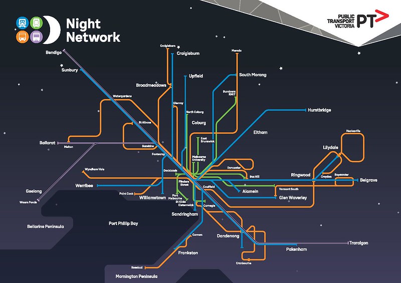
Labor’s “Homesafe” has been rebranded “Night Network“. The 12 month trial starts in January, with hourly suburban trains on all routes, half-hourly trams on 6 routes.
Full timetables aren’t out yet, but some reasonably good new maps are… note the symbolism of the Pakenham and Sunbury lines, diagonal straight through the middle — as it will be (more or less) in reality when the metro tunnel is open.
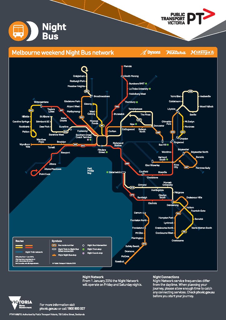
Nightrider is renamed Night Bus, with a re-organised network of 21 routes, with about half the routes originating in the city (including running a CBD loop anti-clockwise along Flinders, Russell, Lonsdale and Queen Streets) every half-hour, and the rest running suburban routes, co-ordinated with trains at some stations.
This is good — it made no sense to retain the existing Nightrider routes, which largely replicate rail lines. That said, it’s unclear if the suburban bus routes match the most heavily used daytime bus routes. They’ve included parts of the Dandenong/Knox City/Ringwood Smartbus, which is good, but other routes such as Elsternwick to Bentleigh are quite different from the day network. It’ll be interesting to see how successful these are.
To the regions there’ll be 4 Night Coach routes, departing at 2am.
It all looks pretty good, with some caveats. Hourly trains will solve the Nightrider bus capacity problem, but at the expense of frequency — they may or may not be attractive to enough people to keep the trial going after a year. (The publicity indicates stations on two lines, eg Caulfield, Clifton Hill, Footscray will get half-hourly trains.)
Oddly Southern Cross (and the City Loop) will be closed after 1am, with trains not stopping there, making it more difficult to get there to catch the Night Coaches or Skybus (which runs 24 hours) — though some of the Night Buses and Night Trams will stop there.
Apart from those out late at night, it will also finally fix the lack of services for early Sunday morning events, such as fun runs — Melbourne’s Sunday morning trains reach the CBD later than in any other city in Australia.
And it’s good to see that PTV is seeking feedback on the night network.
22 replies on “A quick look at PTV’s Night Network”
Interesting that they’ve kept the Bay in the map for this despite their refusal to on the incoming train network map.
Overall, this makes it more difficult for me to get home because the frequency of once every half an our on my nearby NightRider route will be reduced to once every hour for a train line. It will be good to see if using trains and trams instead of buses makes the network much more utilised.
Comparing Footscray to say Clifton Hill, it makes it look almost like Werribee/Williamstown trains will terminate at Footscray instead of continuing.
I’m looking forward to seeing the timetables, i.e. express time Flinders St to North Melbourne. Used to be 5 minutes. Also, should be interesting to see how quickly the trams operate when not competing for road space, but still making regular stops.
Interesting that both the Upfield line and #19 tram are operating – perhaps close Upfield and extend the 953 from Broadmeadows to the #19 terminus?
Also surprising that Seymour doesn’t get a coach service.
For through-routing, I’m guessing Craigieburn/Upfield form South Morang/Hurstbridge; and Werribee forms Frankston, leaving Sandringham and the Burnley group terminating at Flinders St?
Alternating shuttles from Ringwood makes little sense; I’d run Lilydale’s through and Belgrave shuttles, since Belgrave has more single track and fewer bus connections. Doing that also simplifies running at Ringwood.
I may have missed this, but is there confirmation that services will run right up to ~1 hour before the current Sunday morning services? E.g. currently the last Night Rider (970) service leaves the city at 5:30am, leaving a 2.5 hour gap until the first train service leaves Flinders St. for Frankston at 7:58am.
@David.
If theyre not running Upfield they’d need to ensure everyone past Batman has been catired for by one of the bus routes. With Upfield though this means a decent 3 services per hour (2 trams 1 train) up to Batman.
Interestingly, the PTV website states “A new fare will be charged … when touch on occurs after 3am, as public transport fares switch to a new day at 3am. I think this should be changed to 5am or even later since the first “regular” train/tram doesn’t start until then.
@Nick, all of the rhetoric has been about running services 24 hours at weekends, so I think we’ll see that yes the gaps are filled.
@Roger, actually many services start just after 4am, particularly on the longer lines. Remember that the new fare isn’t charged for a trip already in progress. Anyway I don’t think it’s unreasonable to charge for trips commencing after 3am… it might help with cost recovery a bit. And treating 6pm-3am as one block is something of a bonus anyway.
Interesting and valid comments here: http://transitmaps.tumblr.com/post/132194827045/melbourne-night-map-2015
A similar sentiment from the same blog for London’s night tube service – (proposed then pulled indefinitely when discussions with unions stalled – should we be worried here that a similar situation may occur re: night services?) : http://transitmaps.tumblr.com/post/122248792205/london-night-2015
Pretty ordinary effort on the first map — as http://transitmaps.tumblr.com/post/132194827045/melbourne-night-map-2015 points out, it’s excruciatingly vague on a lot of locations, including Flinders Street station. Useless for actually navigating the network, and terrible for colour-blind users.
Overall a very good Initiative although it would be good to add the number 6, Glen Iris tram to the network as there is a gap in the southeast for trams and it connects Chapel St and many active night hot spots in the south east.
If anyone wonders at the reasonably good patronage of the trams despite their slow speeds it should be noted that the frequency of these night tram routes will match or even exceed many suburban bus routes during the day or even peak times.
Thanks to @Adam and @Phil for the link to the map review. (They posted it independently, and couldn’t see each others’ comments until approved.)
Yeah the more I look at the maps, the more I see problems – the biggest one I think is that the overall map and the Night Bus map should have been combined. The latter has a reasonable amount of detail. If they could have got the 6 tram routes onto that, it would have done a much better job of representing the Melbourne portion of the network… and given the regional network is so sparse (4 coach routes) I’m sure that could have been shown with arrows heading off the map to the SW, W, NW and E.
The third main map is the CBD bus loop – see here.
Ahead of individual route maps being published, there are also detailed bus route descriptions available.
I find it interesting that the CBD bus stops are being moved from Swanston Street to Queen Street, the latter is both an existing bus artery by day, and a major taxi rank for revellers at night.
I have just noticed, the Altona loop is not shown but all other electric lines are. They are using only buses (944 point Cook) for Altona.
Once again Melton is the poor cousin with no trains and a bus to and from Watergardens, with Deer Park served by a bus to and from the city.
Do we know what is happening with weeknight services?
@Marcus, yeah note most of the stops they’ve chosen have no amenities such as seats and shelters. Perhaps they’ll be putting some in before Jan 1.
@Tom, the very stylised overall map implies Altona doesn’t get trains, but the Night Bus map shows the Point Cook bus and the train together in Altona. The Night Train page says: Night Trains will stop at all stations on the rest of the metropolitan rail network, except on the Stony Point and Flemington Racecourse lines where trains will not operate.
It also notes where shuttles will run (Cranbourne, Alamein, alternating Lilydale/Belgrave.)
Melton also gets the 2am Night Coach.
What’s happening with weeknights? Nothing.
A few points:
1. The decision to exclude Southern Cross and the City Loop is odd given connections to V/Line and Airport Services as well as peoximity to Docklands, Crown and other night spots. Could be included if the trial is successful.
2. With regards to the Night Coaches, if demand is there perhaps they could alter the times and add an extra coach. Have departures perhaps at 1:00am and 3:00am.
3. The Night Buses should run during the week (Monday morning to Friday morning) to fill gaps and service ahift workers, airport commuters and late night events (concerts, gigs, etc.)
All up its a good initiative and I believe it will suceed. Once the trial is finished it should be expanded where apprpriate and train frequency improved.
Regarding Southern Cross Station, my theory for it being omitted from the ‘Night Network’ is the Public Private Partnership that governs the operation of the station. Everything the operator is required to do is specified down to the n-th detail, which presumably means any changes to opening hours would require a contract variation, and extra $$$ to the operator.
Some of the V/Line stations will be difficult to service by coach.
Taking note of some of the comments on the #Bustituion post, my suggestion is to run coaches down main streets, and use Maxi Taxis to service the diversion to each difficult station.
Because the impact of a mistake is high, the taxis and coach drivers should be required to exchange tags at each stop.
Example (fictional V/line station Kiwitown).
02:30 Maxi Taxi turns up at Kiwitown station and waits for 15 minutes.
02:45 Maxi Taxi departs Kiwitown, taking 10 minutes to drive to its shadow coach stop.
03:00 Coach arrives at Kiwitown Shadow Coach Stop. Passengers exchange between taxi and coach.
Also – taxi hands a taxi-tag to coach driver, coach driver hands a coach-tag to the taxi driver.
03:01 Coach continues, and Maxi Taxi returns to Kiwitown station (if there are any passengers from the coach).
03:11 Maxi Taxi arrives at Kiwitown station.
Result: each Maxi Taxi started with a taxi-tag, and will finish with a coach-tag. The coach driver started with a bunch of coach tags, and will finish with a bunch of taxi-tags (one for each station so serviced). This is proof that the service was delivered correctly.
Advantage: although the coach has to stop at each station’s shadow coach stop, it’s a lot faster than actually diverting to the station.
Further to @Tom’s comment on the Altona Loop (on stylised maps):
Perhaps they should put a kink on the blue railway line, and write the word Altona. And perhaps shift the bus connection to Point Cook further west on the map, so that the kink and “Altona” can fit in.
On the bus map, the faint blue train line to Werribee has a few funny kinks, which is counter-productive. It should be straight, like the overview map, except for the Altona Kink as I’m suggesting for the overview map.
Is it worth replicating the City Loop with buses in both directions, perhaps with a 10 minute frequency, if they can’t/won’t open the actual train loop?
Marcus has a good point as to why Southern Cross is not included. But, Southern Cross in my mind, should be the major hub for all transport through the city. It is mad not to include Southern Cross as part of this.
I would question having night trains to Alamein and Upfield lines. You have the #19 most of the length of Upfield, and the old 319 bus could fill in the gaps to Upfield, and the Alamein line would be covered by a more direct #75 tram.
Also, trains beyond Dandenong and Ringwood and Greensbourgh/Eltham, a connecting bus may be better, and have half hourly trains up to those points.
On the other side, A night V/Line train on the Geelong line would be a good idea, even if it connects at Werribee with Metro trains.
I am surprised not to see #59 tram included.
What about PSOs?
As for the buses, I would prefer that all the SmartBus routes where to operate hourly all night long, and along the original smartbus route too.
As for the all night trams, could we by any chance get a better allocation of low floor trams, given I trust we would have more than enough low floor trams to cover all of these routes on these nights. It is only Carneggi which could get D1s from Malvern and Vermont South which could get Es from Southbank.
Other than that, #96, #109 and soon #19 are almost 100% low floor anyway, with rumors that #86 is soon to start getting E class trams.
Replacing trains beyond Ringwood and Dandenong would be counter-productive and extend journey times to those similar to the current NightRider (ie. way to long). For example a train takes about 28 minutes to travel 25 km from Dandenong to Pakenham whereas a replacement bus takes 1 hour and a train Dandenong to Cranbourne takes 13 minutes to travel 15 km whereas a replacement bus takes 30 minutes.
I agree with Jim. why would you send trains in the middle of the night to Hurstbridge, Alamein and Pakenham.
That second map looks incomprehensible.
Rising sea levels turned Elsternwick and Carrum into islands now ? Or have they used a colour that only bees can see ?