If you haven’t heard, the train and tram stoppages for Friday have been cancelled.
Say you know which line you want, you’ve found the correct platform, but a train comes in with some obscure station on the destination sign — how do you know if you can catch it?
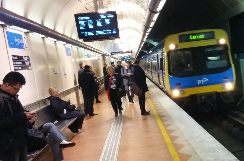
You might have only a few seconds to work out if it’s on your line, and if so, whether it stops at your station. If you’re lucky your station is on the screen, and you have to quickly scan through dozens of place names to find it… but if you’re unlucky, there’s no screen, just a two-line LED display (which may or may not be close enough to read) with the unfamiliar destination and “Stopping all stations”.
With Melbourne’s notoriously inconsistent train operations, this can be quite a challenge.
One way some cities get around this is to use labels that apply no matter how far along the line the train is going.
London uses names that aren’t generally place names — some are cultural references (Jubilee), some reference the central locations they serve (Bakerloo), or have various other names.
Many system maps use colours to distinguish their lines (ours will soon), but some cities such as Chicago and Washington DC use colours as the names for their lines.
New York City uses letters and numbers.
Paris and many other cities use just numbers for the Metro (in Paris they also use letters, for the RER suburban system).
Sydney is hedging its bets – for the moment they have the old names for individual lines and also new numbers (eg T1, T2, T3…) to group the lines.
What is a “line”, anyway?
Perhaps we need to step back a bit and decide what is a train line? Are Pakenham and Cranbourne separate, or one?
I’d tend to go with: if they share most stations and a level of timetable coordination (for instance to ensure even frequencies), as well as sharing tracks, then it’s one line.
That makes Dandenong a line, with branches to Pakenham and Cranbourne. Frankston is a separate line; most stations aren’t common, they mostly use separate tracks, and their timetables aren’t co-ordinated (much).
But South Morang and Hurstbridge are separate lines because they don’t share most stations. Werribee and Williamstown? Perhaps.
Letters for Melbourne?
So… bearing in mind the aim is to help with navigation and being able to quickly work out if you can catch that approaching train, what if Melbourne’s train lines were given letters? Something like this, going anticlockwise…
B = (Brighton and) Sandringham
F = Frankston
D = Dandenong (Pakenham and Cranbourne)
G = Glen Waverley
R = Ringwood (Belgrave and Lilydale)
A = Alamein (because most of the time it’s a shuttle)
H = Hurstbridge
M = South Morang, soon Mernda.
U = Upfield
C = Craigieburn
S = Sunbury
N = Newport (Werribee, Williamstown, Altona Loop).
What about variations? They could be described with a second small letter – Rb for Belgrave, Rl for Lilydale, Dp for Pakenham, Dc for Cranbourne.
Stopping patterns? Fx for Frankston express, perhaps?
Oh, but what about Werribee and Williamstown? N1 and N2? Altona Loop? Na?
Or given most Werribee and Williamstown will be through-routed to Frankston, perhaps you give them a different name? Within Metro they’re known as the Cross-City group, but maybe you could call them Bayside or something?
What happens when a line gets extended? Do you change the name? We do in Melbourne, but in Perth they still call the Joondalup line that, even though it now runs further.
Once the metro rail tunnel opens, Dandenong will connect through to Sunbury, and eventually the Airport. What do you call it then? Call it P for the Parkville line? Or stick with D for Domain perhaps?
In the short term, colours are likely to get more emphasis, as the new map and associated station signage rolls out.
Perhaps the naming is all too hard. But with outbound trains towards Frankston having head boards of “Frankston”, “Carrum”, “Mordialloc”, “Cheltenham” or “Moorabbin”, clearly there’s scope to make things clearer.
27 replies on “What if the train lines were given letters?”
I posted about this a while ago with some suggestions for line names here:
http://jeremyburge.com/post/122324850924/what-should-the-train-lines-in-melbourne-be
I like the idea of line names, and destination markers to know which branch. Eg catch a “Clifton Line” train to South Morang. If the line extends, Clifton Line remains the same, destination changes.
The letters you suggest would quickly become just as confusing as what we have now, because they are referable to circumstances at a particular point in time, ie the names of the lines we now have. It would be better to have as the reference point something that is largely unchanging and easily observable by new and existing users.
My suggestion would be using the map of Melbourne as the reference point, ie start at one edge (eg the most south-west point – Werribee or Geelong) – this would be line A, 1 or a colour (eg red). Then travel anti-clockwise naming lines as you go – with the Frankston line being the end (12, Z, purple). If you used colours, you could have a nice rainbow across the city!
Cross-city lines could be marked in the same way, giving them a number when they are first intersected by the anti-clockwise sweep. Or perhaps they could be given a different system (eg numbers if letters are used for the standard lines or vice versa) to denote that they are cross-city, rather than radial.
It is interesting how many Melburnians don’t like the idea of train lines having a name that isn’t that of the terminus station, yet our city is famous for a tram network – one where every route has a random number signed to it.
To extend Marcus’ comment above, I find the bus timetable section on the PTV website difficult to use – unless you know the bus route number in advance (ptv.vic.gov.au/timetables).
Similarly, if train lines had a number or colour, it might be hard to locate which line you wanted unless you knew the colour or number in advance.
@Jeremy, good job – I guess I’m thinking I wouldn’t group the Northern and Clifton group lines like that… especially Northern – apart from the City Loop, they only have one common station, then branch off in completely separate directions.
@Feline, good point – what I probably should have said is that having taken on the letters (which are allocated to help provide a transition off the line names) you wouldn’t want to change them in the future if you could possibly help it.
@Roger, one of the reasons it’s hard to work out which bus is that there’s no bus network map. Trams use route numbers but have a network map, as would trains. Do you find it an issue with trams?
How does one know one’s local train line name anyway?
What about cardinal directions? That seems to be quite common in a lot of places. Or even direction an number? Craigieburn would be N1, Upfield N2?
When lines get extended, you can then combine so for example Frankston and Werribee being EW – East-west? Or still use the Arbitrary Cc – cross city?
Or we could do the government’s favourite thing, A NAMING COMPETITION!
I quickly learnt the relevant letters for lines in New York we used. I would have never have learnt Melbourne train terminus names in the same time and even The Tube names are harder to remember than just letters.
Cardinal directions is a great idea.
Could take some inspiration from here, if going for letters rather than colours:
http://victorianrailways.net/signaling/autopre.html
(I have a theory that DG was allocated as a reference to the Oakleigh-Burnley route.)
Otherwise, I like the Perth system which uses named lines (some, i.e. Joondalup, are very much out of date and it doesn’t seem to matter – when I was there a few months back I referred to it as the green line, and most people understood), with letters stuck on the end for patterns. Unfortunately we still have too many patterns for that system to work directly, so I’m thinking we might be able to manage something like a three-way code: colour for primary route, 1st letter for express pattern, 2nd letter for short-starting, route variant etc. So in the case of a down Flinders Street to Epping express, the code could be “Red T E a” with the code “T” indicating an express Jolimont-CHL-Preston-Reservoir-Thomastown, “E” for Epping and “a” for Loop After Flinders Street.
Naturally, after clearing the Loop, the “a” would disappear from the code, and after clearing Reservoir, the “T” would clear. This would solve one of my pet peeves – the Route 903 bus timetables still indicating via DFO Essendon when running from say Box Hill to Mordialloc.
Additionally, the “E” would not be shown for inbound trips. There’s no reason for it.
The complex naming variations provided show exactly how complex our system currently is! Simplifying the system will simplify any communication of its functionality.
In the absence (mostly) of express tracks on the Frankston line, not sure why they’re all not “frankston” trains, with some stopping short – if this happens, you’re not going to get to your destination any faster; you’ll have to wait at your origin or at the short terminus for the next train, So call them all the same.
Colours seem to be the most popular, and where a line branches, noting the final destination on a ‘per service’ basis. But it gets complicated if the line branches into more than two, as occurs sometimes (e.g. London’s district line).
@Dave, with a relatively low frequency service like we currently have, that few minutes’ extra wait at the city end could make the difference between time to buy a coffee/etc and not.
@Daniel
“How does one know one’s local train line name anyway?” Because there are only about a dozen lines, it’s not difficult to find one’s train line name. If I’m catching a train to an unfamiliar area, I use Metro website to locate what line the station is on (or hard copy Melways works too).
For someone who has lived in Melbourne almost all my life, names such as “Werribee” and “Broadmeadows” create a picture in my mind of “west” and “north” respectively. Whereas “line A” or “line B” does not do this. For those who are unfamiliar with Melbourne, maybe “line A” and “line B” would be more helpful.
@Daniel I agree that naming all Northern trains “the Northern Line” isn’t ideal – given the variety of places it can go.
The real benefit to naming and colouring the lines would be signage at stations. Platform signage would be for the line name and colour, with destinations then being relevant only to the specific train or direction of travel.
Colour is the best option. In addition to the network map, I’d be interested to know if station signage will be changed as well, doing away with the traditional blue signage which has represented trains.
I work with tourists, and I often find them referring to catching the “yellow line tram” or the “orange line tram” to get to destinations when showing them the tram network map. Overseas, they’re used to referring to lines by colours. As you can see on our network map, we already have coloured lines that are used on both the map and individual route brochures, but no one identifies the routes as such:
http://yarratrams.com.au/using-trams/getting-around/network-map/
15 colours would do it.
It is outrageous that the bay is not shown.
They should show the bay and also put a little surf icon on the map next to stations that are within 150m from the beach.
Then people can know that they can get to the beach by train!
“Metro Fx Up” could get confusing, people might think the F means Flinders St!
Letters are a stupid idea, it’s just a case of copying the latest consultant’s home town, or whatever someone thinks is “hip”. Anyway, it would not help in any way to deal with the real actual problem of a person on the platform, which you allude to in your first paragraph, which is the issue of variable stopping patterns at intermediate stations.
It takes a person entering the Melbourne CBD train-using workforce about a week to learn that Carrum and Mordialloc are on the Frankston line. It’s not rocket science.
The T-scheme in Sydney is a bit of a joke. The T1 line goes to five different places.
In Chinese cities such as Shanghai, Beijing, Hangzhou and Shenzhen, the newly built subway systems use numbers and colours instead of the terminus stations to name each line. They number them based on the order on they were first built such as Line 1 from XinZhuang to FuJin Road was the first time to be built. So if we take that trend into our system, we need to go back into the history books to find which line was first built i.e. Werribee/Williamstown and Sandringham Lines. In the future, after the completion of the Melbourne Metro Rail Tunnel in 2026, I’d love to see Werribee/Williamstown and Sandringham lines be named Line 1 or Line A and the same goes to other railway lines across the network as it’s an easier way for locals and tourists to remember each line. Since the tram network already has taken the single-digit routes so therefore I use letters instead.
Line A – Werribee/Williamstown to Sandringham
A1 – Williamstown, A2 – Werribee
Line B – Lilydale/Belgrave Loop
B1 – Lilydale, B2 – Belgrave
Line C – Craigieburn Loop
Line D – Frankston Loop
Line E – Sunbury to Pakenham/Cranbourne via Melb Metro
E1 – Pakenham, E2 – Cranbourne
Line F – Glen Waverley Loop
Line G – Upfield Loop
Line H – South Morang Loop
Line I – Hurstbridge Loop
Line J – Alamein Loop
@thede3jay, cardinal directions could work, though I think it’d be nice to also reflect stopping patterns – even if they are simplified down to max 2 per line, there’s still a level of complexity there in communicating that quickly to users. As David noted, Perth uses A,B,C indicators.
@Dave, actually the Frankston expresses do overtake stopping trains (on the 3rd track between Moorabbin and Caulfield), so catching the “wrong” (non-optimal) train most likely will result in a longer trip.
@Roger, that’s right – so looking at a map would give you the answer, whether the line names are named after their terminus, or a colour or a number or anything else. Remember that some lines head off in directions that may not be obvious to those going to a closer destination (which creates issues with cardinal directions as well). Eg how would you know to catch a western suburbs train if you need to get to North Melbourne?
@enno, if occasional users take 5 or more trips to figure out what train they need, they might never become regular users. The legibility of the system needs work. I know of real life examples where people have not known the Carrum or Mordialloc train would take them down the Frankston line.
As I said in the post, I don’t know if letters are the best answer, but we can do better than now.
I have been saying this for many years. Decades in fact.
Although I would prefer route numbers to letters, mostly because that would be in tune with the trams and buses of which also form part of this network.
On the other issue, I am supportive of giving names to the railways routes or tracks, in much the same way we do with roads.
Such as, out from Melbourne,
— Upper Bayside – Sandringham
— Lower Bayside – Frankston
— Maroondah – Lilydale
— Princess East – Pakenham or all the way out to Bairnsdale.
— Princess West – Werribee, Geelong and/or Warnambool too
— Bayside branch – Williamstown
— Bayside loop – Altona
We then could have it say, ‘Upper Bayside railway to Brighton Beach’ or ‘Upper Bayside railway’ when it is all the way?
In response to other posts above,
RE *** where people have not known the Carrum or Mordialloc train would take them down the Frankston line.
Having a variant to the tramways A and D to a route number system should do. Although we need to introduce perhaps an E for express too??
Furthermore, Is it dumb people or is it a dumb system?
What I mean here is, A customer needs to have one of two types of lists. One, like the PIDS in the city where they list all the stops made by a train, then the customer needs only look at that list. Otherwise, a map, which clearly highlights short route terminus locations, so a prospective customer could always check that list for the destination of the next train.
Is it a matter of the system not being good enough to provide such information, or are people just do not have a clue as to how to work this out themselves?
At the same time, a person who is new, should always carry a map of some kind on them.
I would say, the system is not well set up to inform people.
-A PIDS showing a list of all stops would be handy on all stations.
-The PTC/PTV have never been prepared to highlight and promote where trains can terminate short at. Something as simple as doing the same stations in bold text would help.
RE: Colors
Colors are a good way to highlight where routes go around on a map.
Route numbers should still be more than good enough for the trams themselves.
Colors can be confusing, for color blind, and when you have many lines, you need many colors. So, you will need colors that look similar which shall confuse people.
Perhaps you could color code groups of routes, much like London Underground. But then, two of them are very confusing, the black Northern group and green District line on the western side, can confuse a few.
I think Melbourne should go with the system used in London and give train lines names.
I really do not think we should use numbers or letters. A unique name for each line is much more meaningful and memorable. Personally, I have found it confusing using metro systems overseas that use letters or numbers, as it is easy to forget or get mixed up which line it is that you are meant to take, the letters/numbers simply don’t mean anything to me.
There are only what, 16 train lines in Melbourne anyway, so it would only be around 16 names. It’s not like bus routes, where there are so many that the only practical system is to use numbers.
And it would be an improvement over the current practice of labelling the service with whatever the terminus station is. As Daniel said, Metro labelling a Frankston line train as a “Carrum” train is very confusing to a lot of people, unless you are familiar with all the stations on the line or live in the area. If I am wanting to travel to Caulfield, and see there is a “Carrum” train, I would have no idea that it would be a suitable trains. If I was looking at the departure board at Flinders St, my eyes would probably pass right over the name, because I am not looking out for the word “Carrum”.
Metro should stick with a consistent line name, and mention where it is terminating if it is terminating early (eg “Frankston line train terminating at Carrum”). Or, for something like the Dandenong line: “Dandenong line train towards Pakenham”.
Daniel, I wouldn’t use N for Werribee and Williamstown when both start with the same letter, W. It would just create confusion.
Plus, unlike the Pakenham and Cranbourne lines which are commonly referred to as the Dandenong line, nobody, absolutely nobody, perhaps except for your own blog posts, refers to Werribee and Williamstown with the name Newport.
Tranzit Jim, there is no major road in Melbourne called “Princess”. Taking an established line name, and replacing it with a road name which is irrelevant won’t benefit anyone, especially when you can’t get the road name right in the first place. If a line needs a new name, it should either be based on that line (ie: Cross City), or something neutral like a number or a colour.
The train lines already have letters allocated to them, next time your at a platform check out the nearest signal, if its an automatic signal it will have a letter infront of the number. B is sandringham, D, Dandenong, F frankston, C Upfield, off the top of my head, but they already do exist.
Some buses have a similar problem. If you are at a unidirectional bus stop like Glen Waverley station, (Forest Hill Chase), and you see a 742 (765) bus for “Heatherdale” (“Brentford Square”), unfamiliar users do not know whether it is going in the right direction toward Eastland (Mitcham), or the wrong direction toward Chadstone (Box Hill), or the right direction but not far enough – eg is your destination beyond Heatherdale?.
Two examples given above (with second example in brackets).
Of course the problem is a bit different, given that the buses have route numbers, but it is similar in that you need to work out which direction the bus is going, and whether it will stop at your stop.
The ferries on the Chao Phraya river (Bangkok) tend to use colour to indicate stopping patterns. Strangely, the Grey Flag (all stops service) only operate during peak hour, leaving some piers without service when peak hour finishes.
But trying to apply colour to the railway system will cause confusion, given the existing (and near future) use of colours to indicate fare zones (and line group).
Sydney buses uses X or E embedded into the route number, to indicate express stopping patterns, so perhaps we can adapt that scheme, starting with A for All-stops. That would therefore dictate using route numbers for trains, like a bus/tram system.
Perhaps Upfield could be route 19, given that it almost mirrors tram route 19 :-)