You might have seen media coverage (Age / Herald Sun) of the new City of Melbourne Draft Walking Plan.
There’s lots of interesting stuff in the document (PDF, 35Mb).
Below are some notes from a skim through. (Page references refer to those at the top of the page, eg numbered from the start of the PDF including cover sheets/intro, not the start of the document.)
p1. The economic benefits from dense city centres and improved walkability, underpinning the need for action: “A 10 per cent increase in the connectivity of the Hoddle Grid’s walking network is estimated to increase the value of the economy by $2.1 billion per year by making it quicker and easier for people to move around the city to do business, access services and jobs.”
p6. The bottom line on numbers: 840,000 people visit the city daily, expected to rise to 1.2 million by 2030.
p10. Updated figures (2011) for journeys to work in the City of Melbourne: Public transport 50.4% (Train 39.5%), vehicle 37.7%, walking 5.5%.
Note that the City of Melbourne is a lot bigger than the CBD, and the Hoddle Grid — I would expect figures for just the Hoddle Grid to show a higher proportion of public transport trips, but this walking strategy covers the whole council area.
p12. Weekday trips within the City of Melbourne are dominated by walking (66%).
p16. The importance of resolving crowding: “Crowding discourages people from walking, creates delays which waste time and money and undermines Melbourne’s international reputation for liveability.”
p20. Yikes: “In the City of Melbourne, a pedestrian is killed or sustains a serious or other injury every two days.”
p21. They’re aiming/expecting to increase walking, and public transport and bicycle use, with private car trips reducing.
p30. They’re seeking to work with the Vicroads SmartRoads network operating plan, which already highlights which streets should prioritise which mode.
p32. Ever wondered why more traffic lights don’t automatically show a green man, even if nobody presses the button? Or wondered what it’s called? Apparently this is called “Auto pedestrian phase signals”.
Sounds like it will be implemented at a lot more crossings, which is good. Why is it important? As the document says: “They reduce waiting times for pedestrians (pedestrians do not miss an opportunity to cross if they get to the intersection after the time a walk phase could start). They give pedestrians a similar level of service to motorists, public transport vehicles and cyclists who do not need to manually activate lights.”
I’ve spotted this at a handful of recently re-programmed suburban traffic lights… would be great to see much more of it — it should be the standard.
p33 has a map of where they plan to implement it, which is encouraging. Thing is, I’d like to see it become the default for all signalised intersections — particularly as typical traffic light programming means a pedestrian who just misses the start of the green phase has to wait until the next one starts to get a green man.
p34 notes some (about 15) CBD intersections don’t have green man displays (“pedestrian lanterns”), apparently a legacy of the original installation in the 1940s! They’re going to install them — I suppose it may seem more restrictive for pedestrians, though as the document says “people with disabilities face significant difficulty when crossing the street as they are not alerted when it is safe and appropriate to cross”.
p36-47 goes into some detail about increasing pedestrian priority across the CBD, with five proposed categories:
- Street as place — eg a destination, for instance Centre Place, Degraves Street
- Walking street — for instance Bourke Street Mall, and proposed for the bottom of Elizabeth Street
- High mobility walking street (public transport corridor) — for instance Swanston Street at present, and proposed for the remainder of Elizabeth Street
- High mobility street (public transport corridor)
- Other streets used by pedestrians
p50 talks about improved maps around the city.
p52. Stop lines to be moved to require motorists to give way to pedestrians when exiting minor lanes.
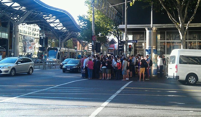
p56-57 talks about works to assist current areas of pedestrian overcrowding, such as around railway stations.
p59. Widen pedestrian crossings at intersections, and build-out kerbs. Also act on motorists who block crossings.
Edit: This page also notes they plan to move blockages such as street furniture (eg bins) away from busy intersections.
p64-69 goes into some detail about access in and around railway stations, including investigating re-opening the Little Collins Street pedestrian subway into Southern Cross Station).
I’m somewhat amused that they believe they need to “investigate ways to encourage use of [the Degraves Street] entrance” to Flinders Street Station. One look at it makes it pretty obvious what the problem is — there’s zero signage telling you it goes to the station.
p72-73. More formal pedestrian crossings, such as mid-block crossings.
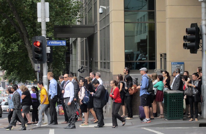
p76-77. It notes that it is completely legal to cross more than 20 metres from a crossing, and because this is important for reducing walking distances and delays, and because they can’t provide crossings absolutely everywhere, they want to make streets easier to cross between the crossings.
The example they give (William Street outside Flagstaff station) is slightly odd — the reason people cross here is to avoid the packed footpaths. It’s unlikely many would cross between the station and the old Mint car park — though some using the car park might be going to nearby buildings.
p84 onwards. The appendices cover a number of interesting topics, including pedestrian countdown timers — not generally seen as recommended as trials haven’t shown they improve signal compliance.
Barnes walks (scramble crossings). They conclude they’re not worthwhile due to overall delays to pedestrians, trams and motorists — though oddly that’s based on a study of two locations seemingly chosen at random. They really should have looked at spots which are more obvious candidates, for instance those with busy buildings on all corners and a railway station on one side: say, Spencer and Bourke, Spencer and Collins, and Flinders and Swanston.
Pedestrian early starts — showing a green man before parallel traffic gets a green light. Fair enough — it’s really of benefit when turning motorists aren’t correctly giving way, and this isn’t a big problem at signalised intersections in the CBD.
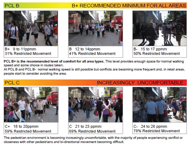
p95. An interesting couple of tables about “Pedestrian level of service” — that is, different standards for how quickly a pedestrian can cross the road at traffic lights.
p96. Another interesting table showing a Transport For London reference on pedestrian comfort levels (PCL), based on how congested a pavement is, measuring the number of people and how restricted movement is at each level.
“At Pedestrian Comfort Level D, walking speeds are restricted and reduced and there are difficulties in bypassing slower pedestrians or moving in reverse flows.”
This is important research — for someone who hasn’t regularly experienced such conditions, it can be difficult to understand why a photo of a bunch of people on a footpath which appears to have plenty of space is, in fact, quite restrictive if you’re actually trying to walk on it. (This is why people resort to walking on the road.)
Conclusion
The draft document makes a lot of good points, and it’s fantastic to see the breadth of thought and research into a topic that’s so important for the City of Melbourne, including recognition of such issues as permeability and crowding levels on footpaths.
Cities like Melbourne need to plan carefully to cater for more pedestrians. On foot (in conjunction with public transport access) is the most efficient way to move more people around a busy city centre.
The only niggle I have is that it completely fails to talk about motorcycles parked on footpaths — as I’ve noted before, the guidelines don’t seem to be well-known (or followed), and certainly aren’t enforceable.
But overall, a big thumbs up — and it’ll be great to see some of the proposed changes implemented.
17 replies on “Some good stuff in the City of Melbourne’s Draft Walking Plan”
“Auto-phase pedestrian crossings” is critically important to delivering an equivalent pedestrian experience as can be found driving when one encounters traffic lights. I’ve copied below a letter recently sent to Yarra Trams to try to get them to kick “auto ped phase” off in the suburbs, given the importance of easy tram interchanges at major intersections. Would be worth trying the same thing at high-frequency tram/bus interchanges (eg along Johnston St, or Hoddle St).
===
Can Yarra Trams please work with VicRoads and local councils to ensure that at all tram road intersection interchanges the pedestrian signal automatically operates.
This already occurs in the CBD grid, and allows easy interchange from one tram route to another. However, in suburban locations, if someone else hasn’t pushed the pedestrian ‘beg’ button, you can disembark a tram and then miss a connection becuase it’s not legal to cross (even if there is ample time to do so in the current phase). Pressing the ‘beg’ button at these default green locations could still be used eg to give a longer pedestrian phase if needed (eg for seniors).
The tram network would benefit from improving the ease of interchange resulting in fewer missed connections, fewer passengers running through traffic to meet a tram, etc. A missed connection offpeak can mean 10-20 minute waits, which is a big disincentive to travel.
There would be no delay to drivers if there are no pedestrians from a default pedestrian green – cars are only required to give way on a ped green if there’s actually someone there, otherwise they can proceed as normal. Therefore, there’s no downside to this change, but a lot of upside for pedestrians and tram passengers.
This is basically a ‘software fix’ – upgrading the effective performance of the tram network for its passengers without expensive concrete or road changes – and could be cheaply implemented immediately.
There is a Barnes walk crossing at the edge of Flinders and Elizabeth streets right now! Although if the proposed changes to the south end of Elizabeth street go through, I guess this will be no longer
Thanks for the insight into this report. I admit that I haven’t read it, but does it mention “clutter” on footpaths? You mention the crowding that occurs on the footpath in William St south of Flagstaff – but part of the issue here that there’s so much “clutter” on the footpath. Yes, I know it’s nice for cafes and pubs to have external tables, but I wonder if these should be reconsidered in places where there are a lot of pedestrians. Likewise, blackboards, ATM machines (resulting in queues), etc.
Thanks for bringing the report to our attention. Let’s hope that the report is more than aspirational and that the council can work with the State government to fund and implement many of the suggestions.
@gxh, it did get a mention, on page 59, but only in the context of near to intersections (such as the bin in the top photo on this post). I can’t see any mentions of it more generally. (I’ve added a reference to it in the post.)
It’s terrific that the council is looking at this stuff; I haven’t read the document yet so I can’t make specific comments. Having lived in London though, I can imagine they do know a thing or two about pedestrian congestion! It’s pretty rare to find similar levels here, but it’s a good thing to start thinking about.
While I agree that it is much better for pedestrians if the man automatically turns green, isn’t there a safety benefit in only turning the man green on if a pedestrian is crossing?
I feel that cars turning left/right into the path of the crossing are more alerted to the presence of the pedestrian when they see that the green man is lit up. If the green man turns on regardless of pedestrians actually crossing there or not, then drivers will be accustomed to that light always being lit up, and it will be much less effective as a warning signal.
Obviously drivers should be looking out for pedestrians regardless of any crossing signal, but still.
A possible solution might be to keep the old system, but allow the green man light to turn on mid-phase if the button is pressed, if there is still time left in the sequence. (Rather than the current frustrating system where you miss out on the green man if you press the button even one second too late.)
All of this applies more out in the suburbs, at intersections where pedestrians are not present as often. In places where it is pretty much guaranteed a pedestrian will be crossing, and pedestrians are the dominant form of transport (eg in the CBD), then it might make sense to turn the green man on automatically.
I notice it took the RACV about 13 seconds to start their usual “if it inconveniences a driver its a terrible idea” tirade.
This is about balance RACV. It is about recognising that pedestrians far outnumber cars in the city, and it is time we balanced the infrastructure to reflect that.
The more roads they close off to cars, the more i am going to have to charge for deliveries to those businesses.
Instead of banning delivery vans on Swanston Street, they should reduce it to a one-lane road (one way).
@Jacob – A small price to pay for businesses given the massive boost in foot traffic that Swanston St has seen since becoming more pedestrianised. Closing off chunks of Swanston Street to cars has been the best thing that has happened in the city for a long while. The blocks around Melbourne Central and the State Library are thronging with people.
I think that it would be a great idea to close off great portions of the city to road vehicles.
Only trams, and if need be, buses.
Just two main north-south routes, and at least one East-West route for the through traffic, otherwise keep the city restricted to delivery vehicles only.
North-South routes, we must retain the Willams Street route, and is it Exhibition street too. I prefer the idea of closing off Spencer Street, just outside of Spencer St/Southern Cross station.
East-West route, we need to retain LaTrobe street for that.
Spencer Street/Collins Street and Flinders Street, should be closed off, with an improved pedestrian interchange with the respective railway stations and their tram stops.
I wonder if we could have some of the major streets closed off, and have four tram tracks built along them?
Some observations:
The map on page 12 is rather odd, they didn’t look at lights on any of the CBD perimeter roads.
They focus on walks 30 minutes or less, which is conveniently the time it takes to walk from Spencer Street to Spring St, a bit over 2 km. The “walking is the easiest way to get there” paradigm tends to start to fall over when the scale of the downtown area exceeds that. Australians are favoured in this respect by their dense but compact CBD areas.
As they say, “time is money”, a lot of walking is done for business, it may be easier to walk 30 minutes than attempt to drive there and park, it is still less efficient than a 5 minute tram ride.
Once you visit overseas cities with larger central areas like Beijing or New York, you start to realise after walking more than an hour from point of interest A to point of interest B, you start to realise that “just walk there” is not as efficient or practical as it seems to be at home.
This problem gets worse when you start to factor in the CBD expansion to places like Fisherman’s bend.
Intra-CBD public transport is poorly handled in Australia, it’s even worse in Sydney than in Melbourne which at least has some useful trams. It is very expensive for short journeys.
If you wanted to improve the convenience and efficiency of intra-cbd transport in the Melbourne CBD, you could start by looking at the bizarre operation of the CBD train loop.
@enno – Once you visit overseas cities with larger central areas like Beijing or New York, you start to realise after walking more than an hour from point of interest A to point of interest B, you start to realise that “just walk there” is not as efficient or practical as it seems to be at home.
It’s a good thing City of Melbourne haven’t released a walking strategy for NYC or Beijing then!
I haven’t spent enough time in Sydney to comment on the state of travel around the CBD, but I think its rich stating that Melbourne’s CBD is difficult to get around. Most people in the CBD arrive and leave by PT, so their travel is free and they are served by a dense network of trams. Another sizable chunk arrive by bike, so they’ve got that option. Even people that drive in (and this strategy is designed to discourage that) can use Melbourne Bike Share which despite its many problems serves CBD travel well (a big part of the programs failure is that is only serves the CBD, precisely the easiest part of the Metropolitan area to get around!).
Docklands certainly is less well connected, but is still served by a few tram routes. I agree that Fisherman’s bend will need some serious thought. It’s a big area and one measly tram line won’t cut it if they’re serious on the densities bandied about.
I think you missed the point, Julian. It is easy to get around by walking. As long as the weather is reasonably clement.
In Sydney, they also released some CBD plan last year, and it also declared that walking is the main way to get around.
That’s fine if the average walk from Office A to Shop B is 5 or 10 minutes, and the maximum walk is 30 minutes tops.
But this model of walking being most efficient starts to break down when the walking goes much beyond 30 minutes. It wastes too much valuable time and it also eventually gets tiring, particularly in bad conditions.
Transport systems focused mainly on bringing people from 7 or 17 or 27 km away, don’t work particularly well for people who want to go 4 km. Compare the Sydney and Melbourne railways to the London or Paris undergrounds which cover a much smaller total coverage area, much more densely. It is quite enlightening to overlay a scale diagram of those networks on a map of Sydney or Melbourne.
That is why plans to expand CBD’s to new precincts outside reasonable walking distance from existing office hotspots, need quite careful consideration of how people are going to get there.
[…] Daniel Bowen commented on this a while back and it’s also mentioned here. […]
[…] Many of these “Little” streets currently have no red/green man (“pedestrian lantern”) fitted, but there seems to be a program to fit them — I recall mention of it in the City of Melbourne Walking Plan. […]
[…] See also: City of Melbourne walking plan […]