Yesterday’s great website discovery: nearmap.com, which shows high resolution (and recent) satellite pictures of Melbourne and other places — a leapfrog over anything currently on Google Maps.
And I discovered that Ormond station has its official three-letter code, OMD, written on the top of it. How odd; I wonder why?
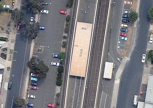
Alas, Frankston doesn’t, and I haven’t found any others so far.
11 replies on “A new tool for spying on the neighbours”
Thanks for the website! Presumably the lettering is there for helicopters??
Could be they were big 80s music fans…
It’s political correctness gone mad, oh my deity indeed!
Recent photos allright – I looked around Oakleigh station and thery pulling down the old Boral Plasterboard factory next to the railway line – that makes it like a couple of weeks old as I’ve seen the progress from the train!!
I’m with Tony. Big 80s music fans. We should look out for a big “TS” made out of bones too …..
Hmmn… Wondering when that image was taken, I’m thinking after evening peak on a weekday – how sad that I recognise some of the cars in the lot, like the turquoise beetle south of one of the trees in the left-hand car park. Not sure, but it might be my blue car further north of the pic although I consciously avoid parking under trees for fear of bird poop…
It is great isn’t it. Maybe OMD is there for easy identification by helicopter pilots when ‘looking’ for someone.
Another interesting and relatively new website is http://newspapers.nla.gov.au
Old Australian newspapers have been scanned and are available online. Readers can make changes as the auto-scanner has trouble interpreting some of the text.
Hi guys,
FYI NearMap will be flying Melbourne, Sydney, Perth, Adelaide and Brisbane (including down to the Gold Coast) once a month. They may fly more frequently if there are special requirements. They will also be doing rural areas on special missions.
The TimeView bar at the top of the website tells you when the shots have been taken. So in Melbourne, there have been 3 flights so far. TimeView allows you to compare an area over a period of time to monitor for changes (eg soil degradation, etc).
Perth is the home of NearMap and you will see there a whole stack of data going back nearly 3 years.
Currently the pixel resolution for most photomaps is 7.5cm x 7.5cm. However there are some super high resolution imagery available – see for instance Perth CBD taken on on 15th May 2009 as well as the recent flight over Rottnest Island. These were done at 3cm x 3cm. You could almost see the wildlife on the ground in those shots.
PS Take a look at http://nearmap.lefora.com and submit any interesting discoveries!
PPS To find out when a shot is taken, you can go to http://www32.webtrak-lochard.com/WebTrak/mel and rewind the clock to see when the aircraft passed over an area
Have fun!
Thanks for the inside info Simon!
Peter, yeah I blogged about the NLA’s project some time ago. It’s good stuff, should go back again and see how the collection is expanding.
If the OMD sign is for helicopters, why don’t more of them have it? (Maybe Tony’s right.)
Nearmap is fantastic! Check it out!!!