Heading south along William Street in morning peak hour, fighting for space on the street, are pedestrians (predominantly coming out of Flagstaff station), trams, cyclists and motorists.
How many of each?
Tram route 55 gets a tram about every 4 minutes in peak hour. The May 2012 PTV load survey said that each tram carries an average of 78.6 people between 8am and 9am southbound (actually measured slightly north from this point), making about 1179 people per hour.
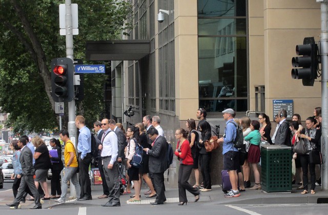
Pedestrians: Marcus Wong recently found some great City of Melbourne CBD pedestrian statistics. At its peak between 8am and 9am, about 5000 pedestrians head south from Flagstaff station.
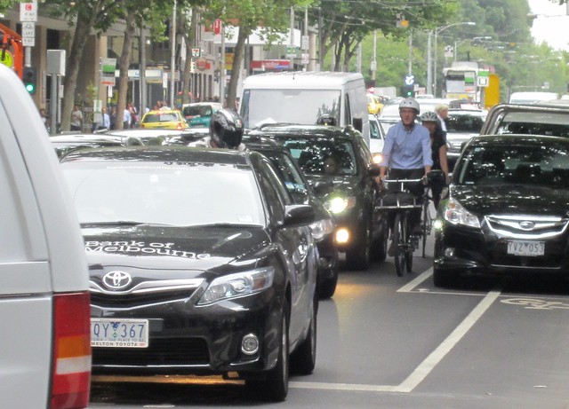
Motorists: Vicroads network performance monitoring figures may or may not be of relevance to this specific street, but show that the arterial road average across Melbourne in AM peak is a bit under 800 people per hour. William Street southbound is only one lane, so let’s use that figure.
Cyclists? Dunno. I see quite a few heading up and down in peak, but the Bicycle Network “Super Tuesday” count doesn’t seem to publicly publish anything useful from the enormous amount of data they collect. Shame. In the absence of other figures, let me take a wild guess at 200 in the busiest hour.
The bike lanes aren’t properly configured. They fizzle-out in places, and around Little Bourke Street (southbound), cyclists often either have to squeeze between cars, or wait for them to shift.
If you assume the footpaths are roughly the same width as each tram/traffic/parking lane, and the bike lanes are half that width, what do you get?
| Mode | % people | % road space |
|---|---|---|
| Pedestrians | 70% | 22% |
| Cyclists | 3% | 11% |
| Tram | 16% | 22% |
| Motor vehicles | 11% | 44% |
The most over-allocated, least efficient mode here is obviously motor vehicles — in part because they are allocated two lanes but one (at least in AM peak) is wasted on parking.
Meanwhile the footpaths get so crowded that many people simply walk on the road. In this terribly fuzzy mobile phone footage, you can see a bloke in a wheelchair give up on the footpath and take-off across the road for the other side:
(Note: it is perfectly legal to cross the road anywhere that is more than 20 metres from a pedestrian crossing.)
What could they do?
They could widen the footpath at the expense of car parking, particularly on the super-busy western side of the street. In the busiest section between Bourke Street and Flagstaff station that’s probably losing about 20 car spots. You’d lose a traffic lane in PM peak, but so what? Traffic is at a standstill now — it would still be at a standstill. If delays got longer, fewer people would drive.
They could install full time bike lanes all the way down. It’s crazy that cyclists get stuck behind cars.
Better enforcement of motorists blocking intersections; you see this every peak hour. (Could be a money-spinner for a cash-strapped government, in fact.)
And more fare gates at Flagstaff could ease congestion there, particularly in morning peak.
Ultimately, the station and trains are the most efficient mode available for getting large numbers of people into and out of the CBD. It already does this very well, but making the area more efficient and safer for pedestrians is vital.
Update: The video keeps disappearing out of this post — possible WordPress bug? The direct link is here.
Update 12:30pm: Someone anonymously sent me a link to what looks like it should be a Bicycle Network page with detailed stats, but it doesn’t work. The region or state specified is invalid
Update Thursday: I didn’t even notice this before — the Clearway (and thus the bike lane) inbound/southbound on William Street only operates during PM peak. What sort of craziness is this?!
See also: Motorcycle/scooter parking on footpaths – In a crowded city centre, this doesn’t make sense.
20 replies on “William Street — too much space for cars?”
Very interesting – yeah, what do Bicycle Victoria do with all their data?
Absolutely agree that bike lanes fizzle out – they are almost useless and very dangerous.
A side issue, but relevant. VicRoads would argue that at least half of the motor traffic in the city is business related (not just workers commuting). Interestingly, I can count four vans in your photo and a Bank of Melbourne car. VicRoads would argue that these people have no alternative but to drive into the city to conduct their business (eg deliveries). As they are contributing more to the economy than others in the city, motorised transport needs to be able to access the city efficiently. Hence, vehicles get more space.
Just got notification at work that there is a bike lane being put into LaTrobe st over the next few weeks, between King and William sts. Let me know if you want to see the plans for the st, I’ll em them through. Very interesting!
The info for the La Trobe St bike lanes is here:
http://www.melbourne.vic.gov.au/ParkingTransportandRoads/cycling/Pages/BicycleLanesRoutes.aspx
And yes, to everything in the post.
Good stuff.
What’s with that weird pole that is in the middle of the footpath when one comes out of Flagstaff also?
It is a big hinderance, and slows traffic exiting the station. When it rains in particular, and there are umbrellas everywhere, it’s pretty dangerous.
Slightly off-topic, but if somebody lights a cigarette and walks to work from the station, that section of the footpath is off limits (for me anyway, and many non-smokers like me).
One doesn’t have that problem in your own car or on the tram.
Whilst I think that pedestrian issues on William Street can be largely attributed to the poor design of Flagstaff Station (and it’s inability to distribute passengers like other loop stations), I agree that the road space allocation here is illogical.
Spare a thought for those few of us who are contra-peaking INTO Flagstaff station of a morning – I almost get bowled over by the hoards every morning, with people glaring at me for daring to walk the opposite way to the rest of the pack. Getting through the myki gates can also be something of an issue!
@Roger, that’s a very relevant point. Note that what I proposed would not affect morning peak at all in terms of traffic flow; the single lane southbound/inbound would remain a single lane.
I would question how many of those vans need to be delivering into the CBD in rush hour, and how many could delay that activity until after 10am. The Bank of Melbourne car might be a company car, but is not necessarily being used (or to be used) for company business – it might just be an upper manager who is given car+car park (a significant generator of traffic in the CBD, I suspect).
@Rae, yeah I’ve seen the plans. Good news, though disappointing they’re not widening footpaths as part of the project.
@Anon, my assumption is the pole is part of defences around the Federal Court building adjacent to Flagstaff station (you can see them on Latrobe Street too), probably to prevent disgruntled crazies driving their cars onto the pavement and smashing their way into the front of the court building. Seem unlikely? Perhaps, but it’s happened before, when the Family Court was at Marland House in Bourke Street.
Taking into account the width available for each mode and the width required per vehicle or person (i.e. each footpath can take four people across, so 5000/2/4), I’m getting these values for percentage of total people per lane-width:
43%-tram, 14%-road, 4%-bike, 39%-footpath.
That’s considerably better than the 22, 44, 11, 22% values listed above.
I do agree that on street parking particularly in built up urban areas on busy arterials is the biggest waste of road space there is. It also limits the capacity of the adjacent lane when people have to mauver into the park. (The mind boggles at how much this space would cost to build new in such an area riddled with services). The only half decent argument for it is that it provides some pedestrian amenity in high speed environments as it somewhat shields pedestrians from fast moving traffic.
When the clearways are active it probably has a theoretical capacity for a large number of vehicles although this would depend on the surrounding intersection signals. I also note that this is not yet a platform tram stop and that perhaps when it gets upgraded to one then we will see a redistribution of road space with it looking more like the spring street end of Bourke Street or similar.
@Austin, the point about isolating pedestrians from speeding vehicles is a good one, though of course the whole Hoddle Grid is now a 40 limit… and right now the capacity issues on the western footpath mean pedestrians are often giving up and walking on the road.
The trams could be encouraged to have a higher patronage southbound by giving more than one Flemington Rd tram route a Williams St version. Possibly even a Royal Parade/Sydney Rd-Williams St route as well (may cause issues at the Haymarket roundabout), although, apart from CBD/Southbank residents, as it would only be not a diversion for Northern group loop passengers, who have the 401 and so it many not divert that many passengers from the Swanston and Elizabeth St trams. The tram route could then be through-routed with revived St Kilda Rd-Williams St tram routes.
The footpaths should be widened.
One idea to reduce congestion at and around Flagstaff, at and around the other CDB stations other than Parliament and at Richmond and North Melbourne as well as possibly on the St Kilda Rd trams, would be to build a new station on the viaduct between Flinders St and Spencers St. It would only be needed on the through (non-loop) track pair on the newer viaduct and possibly on the Clifton Hill loop track (with the same way all day operation).
Perhaps that oversized bin could be better located,
There are proper standards for footpath width e.g. Highway Capacity Manual (US), Chapter 18 (2000 edition a bit old but what is handy) unfortunately Australian standards lag, council’s width specifications lag more and then actual implementation even more. You need to consider the “Effective Walkway Width”, this is not the space between say a pole and a building but the space that is left once you subtract the “shy distances” example 0.5m from the Curb, 0.7m from a blank building face or 1.0m from a building face with window display. Now redo your sums :), you can then work out the Level of Service for pedestrians or average speed if you want (aim for 1.3 meters a second) in the same way you can for people in cars. Oh and then there is platooning effects, cross flows, oh the formulas….
Oh and another thing, notice how much people pay for on-street parking and that it is much cheaper than off-street? You need to read Donald Shoup’s “The high price of free parking” that explains how we perversely make the best parking cheapest by a country mile and then wonder why it’s always full… http://www.nytimes.com/2010/08/15/business/economy/15view.html (New York times article on topic)
Most days I walk the short strip from Flagstaff to the corner of William/Lonsdale shown in your photo. The pavement is in a really bad state; the street fittings are poorly laid out and the signage excessive. Not a lot of foot space.
Add to that: the queue at the Bendigo ATM, the buskers, the chuggers, the slow-moving, can’t-stop-looking-at-my-smartphone crowd, the TV crews and lawyers, congregated outside the court, their subjects chain smoking outside Petty Sessions cafe and the Met Hotel.
Space needs opening up for people at many spots like this around the city, but William St would be a good start.
In parts of the CBD the footpaths are far too small.
The one I see most is the corner of Spencer and Collins.
there’s a square of footpath oppposite the station, outside the Gloria Jeans, that is absolutely rammed every afternoon between 4 and 6.
The pedestrian crossing it serves is about 5 metres wide, but the footpath is perhaps 2 metres wide with lots of obstructions
I often have to traverse it, cross or counter flow, and it sucks.
Council should buy out the Gloria Jeans shop there and turn it into footpath.
What’s the “shy distance” for a garbage bin, alex ?
@Austin ah yes my pet hate, on street parking. Only thing worse than the side of the road parking on arterial streets is the middle of the road parking on arterial streets – Queen and especially Lonsdale, as this parking could be freed up to allow buses a better run, and provide room for cyclists too.
One frequently sees two lanes of traffic held up so someone can park, and plenty of near misses and blowing of the horn too.
I’m sure the only reason these anachronisms are still there are so that our friends at City of Melbourne can make their money – twice of course, once from the parking fees and again from the fines when said car owner gets back late… often because of congestion!
@Jason yes a common issue these days with SO many more people using PT and a larger population working/living in the CBD, yet the same road / pavement space allocations remain.
Collins and Spencer is a nasty spot with pax frequently spilling into Spencer St, surprised there’s not more accidents. Not to mention the usual short pedestrian-green phases so the almighty car traffic can flow quicker (or more frequently, not)
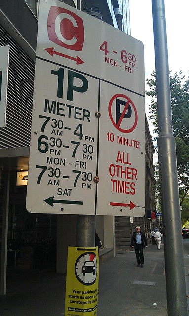
What does the No Parking for 10 minutes mean on the sign? Do you get fined for parking less than 10 minutes? Why isn’t it a Parking Sign for 10 minutes?
The shy distance for a garbage bin in the middle of the path would be 0.3 to 0.4 meters on all sides, assuming it is waist height. If shorter it would be a bit less as your arms would have more room. If the garbage bin is between the pedestrian zone (path) and the curb though it can “hide” in the 0.5m curbside zone and present less of an obstruction if small enough (a 20cm diamter bin?)
[…] CBD footpaths are already congested. As the CBD continues to get busier, it’s going to get worse. In the past ten years, total […]