In the Apple Store at Southland the other day, I noticed they had all the iDevices maps set to satellite.
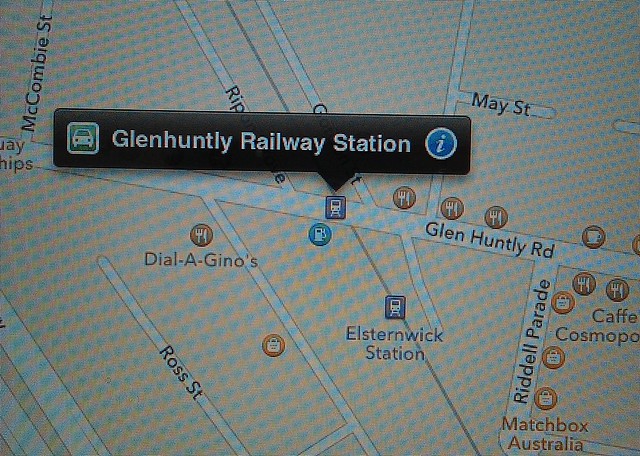
It wasn’t hard to see why — it took all of a minute or two to find some glaring errors in the street maps. It’s not just that tram lines are completely missing; they’ve put whole railway stations in the wrong suburbs.
It’s been well over a month since iOS6 was released… I wonder how long it’ll take them to fix this stuff?
How do mistakes like this even happen?
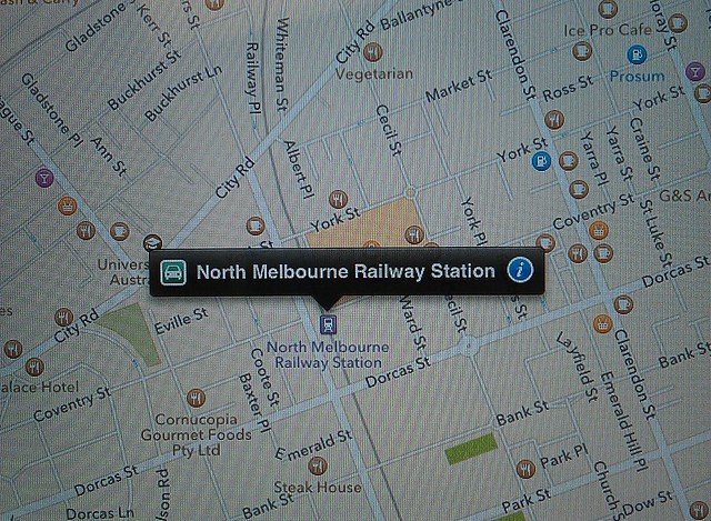
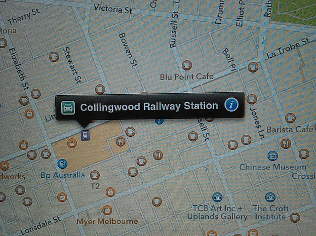
15 replies on “According to iOS6 maps, North Melbourne station is in South Melbourne, Collingwood Station is in the CBD”
Melways wins out again!
Not familiar with the symbols in iOS6 maps, but have they classified the Croft as a museum or somesuch (last photo)?
There’s also a “Fitzroy Station” on the corner of Greeves Street and Gore Street. It is in Fitzroy at least. It’s baffling how they could get it so wrong, and take so long to fix. In the screenshot you posted I see there is also a BP service station in Melbourne Central (presumably its the company’s offices?).
Good to see that they still think the light rail line is a train line. I’m not even sure where they got the garbage data from — they could have used OpenStreetMap (and they claim they did in parts) and it would have been pretty much a better option.
I think it’s probably time they just made the old Google-based app available again — they still have a year on the contract.
So did you click on “report a problem” and send the correct info? That’s what I’m doing right this second!
@roger – they are currently selling reprints of Melways Edition 1 (1966) for $150. it’s a little steep, but they throw in a 2012 Melways with it. I’ve been looking at the maps which are online (http://melwayed1.melway.com.au/mwyedn1.htm) for ages and $150 or so is about the price it would have cost me to print all the pages on a colour printer the last time I thought seriously about doing so … the oversize box they ship them in is a little naff, but otherwise I thought it well worth it …
Malcolm, I actually meant that using old technology (e.g. hard copy of latest Melways) is more accurate and reliable than using latest electronic gizmos. But I am slightly tongue in cheek.
@Mark, no, I was out for shopping, not to do Apple’s work for them.
Is it just me or is Swanston Street no longer a major road? Major roads appear to go straight from Russell Street to Elizabeth!
How do mistakes like this even happen ?
Easy. Indians in Bangalore have no clue about the layout of Melbourne.
And, to be fair, I have no clue about the street map of Bangalore. But then I am not trying to prepare a map for them.
@Mark, I gather Apple’s maps (like Google’s) think the only person who might ever want to go from one building to another will do it from the inside of large motorised vehicle. I suppose to a large extent this is the fault of whoever they get their data from; I doubt there’s any large databases of streets according to a human’s experience. (I’ve sometimes contemplated compiling one, but I only have vague ideas about it. And from where I live, the only classifications would be “walk on this road if you have a death wish” and “boring residential street that twists and turns so you’ll always walk away from wherever your destination is”.)
Thing is, Apple’s product will almost always be illegal to use it from the inside of car, unless you’re taking directions from a passenger.
@Mark – That probably relates more to the closure of automobile traffic than an actual mistake. It looks even stranger on Google Maps these days: http://maps.google.com.au/maps?q=Swanston+St,+Melbourne+Victoria&hl=en&ll=-37.811835,144.966338&spn=0.009578,0.017831&hnear=Swanston+St,+Victoria&t=m&geocode=Fb4gv_0dKPajCA&z=16
Around me it’s all screwed up. Rockhampton is about 100kms out of place. Yeppoon isn’t important enough to have it’s name displayed at all. My town is missing all together. Curtis Island has been joined to the mainland.
I love how when you zoom in and out it chooses what road names to display based on a formula that makes the map look pretty, instead of having major roads appear first.
To think people queue up and fork out huge money for this sort of rubbish. I’m glad to be escaping the apple ecosystem.
And to think I’m annoyed by Google getting a restaurant out by one shop in a group.